
Hebden, North Yorkshire
| Hebden | |
|---|---|
 Hebden Post Office | |
| Area | 14.50 km2 (5.60 sq mi) |
| Population | 216 [1] |
| • Density | Template:Pop density mi2 to km2 |
| OS grid reference | SE02606317 |
| • London | 190 mi (306 km) |
| Civil parish |
|
| District | |
| Shire county | |
| Region | |
| Country | England |
| Sovereign state | United Kingdom |
| Post town | SKIPTON |
| Postcode district | BD23 |
| Dialling code | 01756 |
| Police | North Yorkshire |
| Fire | North Yorkshire |
| Ambulance | Yorkshire |
| UK Parliament | |
Hebden is a small village and civil parish in the West Riding of Yorkshire in the Craven district of North Yorkshire, England, and one of four villages within the ecclesiastical parish of Linton. It lies near Grimwith Reservoir and Grassington, in Wharfedale, within the Yorkshire Dales National Park. In 2001 it had a population of 216 and 133 dwellings.
Hebden has a church, a chapel, a hotel and public house, a community hall, a post-office and general store, and is well served by buses. Until 1983 it had its own primary school. Hebden straddles a cross roads. The main east-west B6265 road connects it with Grassington Template:Mi to km to the west, and from there south to its market town of Skipton, Template:Mi to km from Hebden. To the east, the road crosses a fine bridge over Hebden Gill, built in 1827, and thence over the watershed to Pateley Bridge in Nidderdale, 8.5 miles (13.7 km) distant.
Main Street, forming the high street for the village, continues south as Mill Lane, towards the bank of the River Wharfe and the villages of Hartlington and Burnsall, the latter being just over 2 miles (3.2 km) away. The road to the north runs to the small hamlet of Hole Bottom, from there continuing as a track onto Grassington Moor.
Historically a part of the West Riding of Yorkshire, the village has its recognisable roots in manorial times, but during the nineteenth century it became a substantial industrial village with lead mining and cotton milling as the main industries. Since then it has reverted to a small rural community, and is now a focal point for walkers and cyclists wishing to enjoy the local countryside.
History
The name Hebden is considered to be derived from either heope, Old English for a rose-hip or heopa, Old English for a bramble, and dene, Old English for a valley.[2] Two Bronze Age stone circles and remnants of huts on the moors above the village show that the area has been settled since earliest times,[3] and place names such as Scale Haw show that the Norse left their influence,[4] but there is no documentary record of the area until a brief mention in the Domesday Book of 1086,[5] in which it was referred to as Hebedene.
During medieval times, an important east-west droving route, which was used to move sheep between winter pastures around Fountains Abbey and summer pastures around Malham, crossed Hebden Beck at Hebden.[6] This droving route broadly followed the line of the North Craven Fault, thereby avoiding the moorland peat bogs, and it became a busy packhorse route for traders.
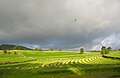
Although no property within the village is older than seventeenth century, its layout reflects its development in medieval times as a planned village. Eight toft compartments are still discernible to the west of Main Street, and the outline of the four surrounding common fields, now divided, may be identified from the pattern of dry stone walls.[7] These fields were then largely arable, providing the village with most of its food requirements, but are now farmed exclusively for pasture and hay.
The last stretch of Hebden Beck before it reaches the River Wharfe was first used to power a corn mill in the Middle Ages, and corn milling survived into the middle of the nineteenth century.[8] In the fourteenth century Fountains Abbey had a wool fulling mill in the village.[9] At the end of the eighteenth century a cotton mill was built alongside the corn mill, and this was productive until 1870 when it was eventually driven out of business by the more efficient stream-driven machinery of the industrial revolution. At its peak, the mill employed over 70 men, women, and children. The building continued to fulfil a variety of roles, including a roller skating rink, but was eventually demolished in 1967.[10]
Lead mining on Grassington Moor became important in the 1700s,[11] and from the early nineteenth century Hebden served as a dormitory village for some of the miners, helping the population rise to over 500 in the 1830s.[12] In the early 1850s profitable mines were established within the parish to the north of the village on veins associated with Grassington Moor,[13] which led to a doubling of the population to over 1,000 in 1861.[14] However, although activity continued sporadically into the last decade of the century, the accessible ore was largely exhausted by 1865, and the population steadily declined.

The prosperity brought by the mines was a significant factor in the remodelling and redevelopment of much of the village. Green Terrace, which includes the Post Office, was built in the 1870s, and Main Street was transformed from a humble back lane into the high street.[15] The village school, with working clock and bell tower, was built by the community in 1874,[16] and the Ibbotson Institute, a well-built stone building which serves as a community hall, was completed in 1903.[17]
The opening of the Yorkshire Dales Railway to Threshfield in 1902 opened up Hebden as a destination for both day visitors and holiday makers.[18] A purpose-built timber guest house opened in 1909 at the south end of the village to cater for the new demand, and it continued in business, mainly catering for school parties, until 1990.[19]
Although it now has its fair share of second homes, holiday cottages and commuters,[20] with eight working farms, a fish farm, coach and haulage companies, Hebden remains a working and thriving community.
Governance
Hebden lies within the Parliamentary Constituency of Skipton and Ripon, with the seat held by Conservative member David Curry MP;[21] and within the Mid-Craven electoral division of North Yorkshire County Council, represented by Conservative member, County Councillor Shelagh Marshall.[22][23] Hebden is also within the Grassington ward of Craven District, a non-metropolitan district, which is represented by Conservative member, Councillor Richard Foster.[24][25]
Hebden has a parish council with five independent members supported by a parish clerk.[26] Elections are held every four years, with the most recent held in 2008. Council meetings are held every six weeks. The parish council activities are largely funded from the proceeds of the annual letting of parish lands.
Before local government re-organisation in 1974, Hebden was in Skipton rural district in the West Riding of Yorkshire.[27]
Geography

The south-east boundary of Hebden Parish runs along the River Wharfe, 500 feet (150 m) above sea level, and the north-east boundary runs along the Wharfedale-Nidderdale watershed, reaching a height of 1,770 feet (540 m). The upper section of the eastern boundary runs along Gateup Gill, one of the main inflows of Grimwith Reservoir. The parish approximates a parallelogram in shape, averaging under 1.5 miles (2.4 km) in width and some 5 miles (8.0 km) in length. To the north, the land rises away from Hebden up to the 2,310 feet (700 m) summit of Great Whernside, some 7 miles (11 km) distant.[28]
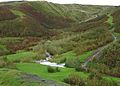
The habitations and main farming are largely confined to the area within the Wharfe valley, with the rest of the land being mainly rough moorland pasture. Hebden village is positioned on one of several branches of the North Craven Fault where Hebden Beck emerges from the moors through a steep-sided valley into the Wharfe valley, at an ancient east-west route.
Hebden Beck rises on Grassington Moor some 2.5 miles (4.0 km) from the village, but the main valley continues north as a dry valley, until it reaches Mossdale Caverns and the upper flanks of Great Whernside.
The geology is dominated by rocks Carboniferous in age but, as the parish straddles a complex section of the North Craven Fault, it is varied. To the north-east of the village the rocks are predominantly Bowland sandstones and shales, and to the south-east are largely massive limestones. The River Wharfe runs across the limestone, through the impressive gorge of Loup Scar. Mineral veins cross the Bowland series, and these have been exploited for their lead ore.[29]
Landmarks

Hebden is a popular centre for walkers and cyclists in Upper Wharfedale. It has an inn,[30] a shop, and a tea room to help meet the needs of its many visitors, and within easy walking distance are the attractive Dales villages of Appletreewick, Burnsall, Thorpe, Linton and Grassington. Grimwith Reservoir, popular with wind surfers, dinghy sailors, and bird watchers is 2 miles (3.2 km) to the east along the B6265, and a further 2 miles (3.2 km) brings one to Stump Cross Caverns - a show cave.
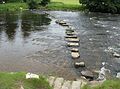
Because of its proximity to the Craven Fault, the scenery is remarkably varied. The Dales Way[31] passes through the parish as it follows the banks of the River Wharfe between Burnsall and Grassington, mainly through peaceful limestone pastures but occasionally, as at Loup Scar and Linton Falls, through limestone gorges and past waterfalls. It crosses the River Wharfe at Hebden by means of a wrapped steel-cable suspension bridge, a few yards upstream of a reconstructed course of medieval stepping stones. The bridge was built in 1885 by local blacksmith William Bell, and paid for by public subscription. A construction of recycled materials, which originally featured a central supporting pier (the base of which can be seen in low water conditions), it has been well conserved and is a popular landmark on the river-side path.[32] Hebden Beck flows down from Grassington Moor, which is dominated by the long-abandoned remains of the lead mining industry, through a splendidly rugged and wooded gill, past the small hamlet of Hole Bottom, made famous by William Riley's novel Jerry and Ben,[33] and thence over the attractive 16 feet (5 m) Scala Falls.[34] A popular walk is an 8 miles (13 km) circuit up to Grassington Moor, and thence to Grassington, returning along the River Wharfe.[35] South of Hebden, the edge of the limestone is heralded by a number of text-book examples of reef knolls, including Elbolton Hill, Stebden Hill, and Kail Hill depicted below, which are the conical remnants of limestone reef structures.[36] Behind the reef knolls lies a large expanse of Grassington Grit grouse moor, Thorpe Fell and Burnsall Fell, where further walking may be enjoyed - especially around the edges.
Conservation area
In 2006 the Yorkshire Dales National park Authority designated Hebden as a Conservation Area. In the proposal it was stated that:
"The special character of Hebden is defined by a historic settlement pattern of great significance together with a collection of important listed buildings and a group of unlisted buildings which, although essentially vernacular and humble in architectural terms, combine well together to create a harmonious and generally high quality environment of buildings, open spaces and tree cover. In addition, the setting is very distinctive with natural topography of surrounding hills and adjacent steep sided valley combining with a man made agricultural landscape of some age and significance in its own right."[37]
Religion

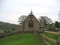
Hebden is part of the ecclesiastical parish of Linton within the Diocese of Bradford, and has a chapel of ease built in 1841, dedicated to St. Peter and now a Grade II listed building.[38][39] There is also a Methodist chapel built in 1812, which is part of the Skipton and Grassington Methodist Circuit.[38] Because the congregation is small, the Anglicans and Methodists share a single service on Sundays, alternating between the venues.[40]
Public services and transport
Local medical facilities are provided by the medical centre in Grassington,[41] and hospital facilities are provided by the Airedale NHS Trust[42] at Airedale General Hospital in Steeton, some 18 miles (29 km) away. Ambulance services are provided by the Yorkshire Ambulance Service NHS Trust,[43] who have an ambulance station in Grassington.
Fire fighting services are provided by North Yorkshire Fire and Rescue Services, who maintain a retained fire station in Grassington,[44] and cave and mountain rescue services are provided by the Upper Wharfedale Fell Rescue Association,[45] also based in Grassington. Police Services are provided by the North Yorkshire Police. The nearest manned police station is in Skipton, but there is a team of officers based in Grassington.[46]
Electricity distribution is the responsibility of YEDL, who are wholly owned by CE Electric UK. Water is supplied by Yorkshire Water from Embsay Reservoir.[47] Yorkshire Water are also responsible for wastewater disposal, and a small-scale treatment plant is located adjacent to the River Wharfe south of Hebden Beck. Refuse collection is handled by Craven District Council,[48] and North Yorkshire County Council provide a household waste and recycling centre at Skibeden,[49] between Bolton Abbey and Skipton.
The village is well served by buses, with services available to Skipton, Ilkley, Buckden, Harrogate and Ripon.[50][51]. The nearest train station is in Skipton, with services to Leeds, Bradford, Carlisle, and Carnforth, and the nearest international airport is Leeds Bradford Airport.
Gallery
-
 View of Hebden from the NNW, Spring 2008
 -
 Hebden School, now a tea room
 -
 View across Hebden's old SW Field with mown hay
 -
 Stepping stones across the River Wharfe
 -
 Miners' path to lead mining shaft, Bolton Gill
 -
Ruin of mine shop, Hebden Gill
-
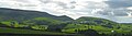 Kail, Stebden, & Elbolton reef knolls, from Hebden
 -
 Children's egg & spoon race, annual Hebden Sports day, 2008


References
Notes
- ^ "2001 Census: Key Statistics: Parish Headcounts: Area: Hebden CP (Parish)". Neighbourhood Statistics. Office for National Statistics. Retrieved 2008-09-10.
- ^ Thurlow, William (1979). Yorkshire Place-Names. Dalesman Books. p. 30.
- ^ Joy (2002), pp. 14–15.
- ^ Joy (2002), p. 16.
- ^ "National Archives: Domesday Book: Hebden, Yorkshire". Domesday Book. The National Archives. Retrieved 2008-10-10.
- ^ Raistrick (1976), p. 5.
- ^ Joy (2002), pp. 18–26.
- ^ Joy (2002), p. 19.
- ^ Raistrick (1976), p. 15
- ^ Joy (2002), pp. 46–50.
- ^ Raistrick, Arthur (1973). Lead Mining in the Mid-Pennines. Truro: D. Bradford Barton Ltd. p. 90.
- ^ Joy (2002), p. 50.
- ^ Gill, M.C. (1994). The Wharfedale Mines. British Mining. Vol. 49. Keighley: Northern Mine Research Society. pp. 97–120. ISBN 0-901450-41-3.
- ^ Davis, V. The Effect of Lead Mining on the Population of Villages in the Wharfedale Mining Field 1853–1880. Memoirs. The Northern Cavern and Mine Research Society. pp. 8–9.
{{cite book}}: Unknown parameter|coauthors=ignored (|author=suggested) (help); Unknown parameter|origdate=ignored (|orig-date=suggested) (help) - ^ Joy (2002), pp. 69–70.
- ^ Raistrick, Elizabeth (1971). Village Schools. An Upper Wharfedale History. Clapham (via Lancaster): The Dalesman Publish Company. pp. 41–44.
- ^ Joy (2002), p. 80.
- ^ Awdry, Christopher (1990). Encyclopaedia of British Railway Companies. Sparkford: Patrick Stephens Ltd. ISBN 1-8526-0049-7. OCLC 19514063. CN 8983. p. 112.
- ^ Joy (2002), p. 83.
- ^ "2001 Census: Key Statistics: Parish Profile - Work and Qualifications: Area: Hebden CP (Parish)". Neighbourhood Statistics. Office for National Statistics. Retrieved 2008-09-20.
- ^ "Skipton & Ripon 2005 Election Result". BBC News. Retrieved 2008-09-23.
- ^ "2009 election results for Mid-Craven ward". North Yorkshire County Council. Retrieved 2009-06-05.
- ^ "Councillor Shelagh Marshall". North Yorkshire County Council. Retrieved 2008-09-19.
- ^ "2005 election results". Craven District Council. Retrieved 2009-06-10.
- ^ "Councillor Richard Foster". Craven District Council. Retrieved 2008-09-19.
- ^ "Hebden Parish Council". Craven District Council. Retrieved 2008-09-19.
- ^ "Hebden Tn/CP". Vision of Britain. Great Britain Historical GIS Project. Retrieved 2008-10-27.
- ^ 1:25000 Explorer Map: Yorkshire Dales Southern & Western Areas (Map) (A1 ed.). Ordnance Survey. ISBN 0-311-92365-52.
{{cite map}}: Check|isbn=value: length (help) - ^ W. W., Black (1950). The Carboniferous Geology of the Grassington Area. Proceedings of the Yorkshire Geological Society. Vol. 28. pp. 29–42.
- ^ "Clarendon Inn, Hebden". Retrieved 2008-10-11.
- ^ Hanlon, Paul (1998). Dales Way Companion. Hillside Publications. p. 29. ISBN 1-870141-09-1.
- ^ Joy (2002), pp. 77–78.
- ^ Joy, David (1991). Uphill to Paradise. Hebden, Skipton: Jerry and Ben's.
- ^ Fellows, Griffith (2003). The Waterfalls of England. Sigma Leisure. p. 113. ISBN 1-85058-767-1.
- ^ Unsworth, Walt (1989). Classic Walks in the Yorkshire Dales. Yeovil: Oxford Illustrated Press Limited. pp. 113–117. ISBN 1-85648-207-3.
- ^ Ramsbottom, W.H.C. D.H. Rayner and J.E. Hemingway (ed.). The Geology and Mineral Resources of Yorkshire. Yorkshire Geological Society. pp. 61–64.
{{cite book}}: Unknown parameter|coauthors=ignored (|author=suggested) (help); Unknown parameter|origdate=ignored (|orig-date=suggested) (help) - ^ "Proposed Conservation Area Designation for the Village of Hebden" (PDF). Yorkshire Dales National Park Authority. Retrieved 2008-11-03.
- ^ a b Joy (2002) p. 64. Cite error: The named reference "joy-64" was defined multiple times with different content (see the help page).
- ^ "St. Peter's Church, Hebden". Retrieved 2008-10-04.
- ^ "Skipton and Grassing Circuit: Hebden". Retrieved 2008-10-04.
- ^ "Grassington Medical Centre". Retrieved 2008-10-11.
- ^ "Airedale NHS Trust". Retrieved 2008-10-11.
- ^ "Yorkshire Ambulance Service". Retrieved 2008-10-11.
- ^ "North Yorkshire Fire and Rescue Service". Retrieved 2008-10-12.
- ^ "The Upper Wharfedale Fell Rescue Association". Retrieved 2008-10-12.
- ^ "North Yorkshire Police". Retrieved 2008-10-12.
- ^ personal communication from Yorkshire Water Customer Services, 14 October 2008
- ^ "Refuge Collection". Craven District Council. Retrieved 2008-10-12.
- ^ "Skipton household waste recycling centre". North Yorkshire County Council. Retrieved 2008-10-12.
- ^ "Pride of the Dales: Bus Timetable". Retrieved 2008-09-19.
- ^ "Dalesbus: Bus Timetable". Retrieved 2009-05-27.
Sources
- Joy, David (2002). Hebden The History of a Dales Township. Hole Bottom, Hebden, Skipton: Hebden History Group. ISBN 0-945304-30-6.
{{cite book}}: Check|isbn=value: checksum (help) - Raistrick, Arthur (1976). Monks and Shepherds in the Yorkshire Dales. Yorkshire Dales National Park Committee.