
Bila Tserkva
Bila Tserkva
Бiла Церква | |
|---|---|
 Collage of the views of Bila Tserkva, Top left: A view of Ros River and Tsentralnyy Bridge, Top middle: Bila Tserkva National Agrarian University, Top right: The Heroes Hundreds of Heaven Street, Bottom upper left: Kurbas Market Mall, Bottom lower left: Colonnade Echo, Bottom right: Panoramic view of Bila Tserkva with Torhova Square | |
 Flag  Coat of arms | |
 Bila Tserkva Location of Bila Tserkva  Bila Tserkva Bila Tserkva (Ukraine) | |
| Coordinates: 49°47′56″N 30°06′55″E / 49.79889°N 30.11528°E | |
| Country | |
| Oblast | |
| Raion | Bila Tserkva City Municipality |
| Founded | 1032 |
| Magdeburg Rights | 1589 |
| Government | |
| • Head of City Council | Gennadii Dykyi |
| Area | |
| • Total | 67.8 km2 (26.2 sq mi) |
| Elevation | 178 m (584 ft) |
| Population (2015) | |
| • Total | 211,100 |
| • Density | 3,100/km2 (8,100/sq mi) |
| Postal code | 09100-09117 |
| Area code | (+380) 4563 |
| Vehicle registration | AI/10 |
| Sister cities | Barysaw, Jingzhou, Kaunas, Ostrowiec Świętokrzyski, Noginsk, Kremenchuk |
| Website | http://www.bilatserkva.info/ |
Bila Tserkva (Ukrainian: Бі́ла Це́рква [ˈbʲiɫɑ ˈtsɛrkwɑ]; Polish: Biała Cerkiew; Russian: Белая Церковь, romanized: Belaya Tserkov; literally 'White Church') is a city in central Ukraine, the largest city in Kiev Oblast.[1] Bila Tserkva is located on the Ros River approximately 80 km (50 mi) south of Kyiv. The area is 67.8 square kilometres (26.2 sq mi)[2] Its population is approximately 207,745 (2017 est.)[3].
Administratively, Bila Tserkva is incorporated as a town of oblast significance. It also serves as the administrative center of Bila Tserkva Raion (district), though administratively it does not belong to the raion.
History
The town was founded in 1032 as Yuriiv by Yaroslav the Wise, whose Christian name was Yuri. The present name of the city, literally translated, is "White Church" and may refer to the (no longer existing) white-painted cathedral of medieval Yuriiv. Since 1363 it belonged to the Grand Duchy of Lithuania, and since 1569 to the Polish-Lithuanian Commonwealth. The city was granted Magdeburg Rights in 1620 by Sigismund III Vasa.
The Treaty of Bila Tserkva between the Polish-Lithuanian Commonwealth and Ukrainian Cossack rebels under Bohdan Khmelnytsky was signed here in 1651.[4]
Beginning in the second half of the 18th century, Bila Tserkva (Biała Cerkiew), then the seat of the sub-prefecture (starostwo), was the property of the Branicki family. Franciszek Ksawery Branicki, Poland's Grand Hetman, built there his urban residence – the Winter Palace complex and a country residence with the "Olexandria" park (named after his wife Aleksandra Branicka). He founded a Catholic church of John the Baptist and started construction of the Orthodox church which was completed by his successor – count Władysław Grzegorz Branicki. The latter one built also the gymnasium-school complex in Bila Tserkva. Aleksander Branicki, the grandson of the hetman, renovated and finished the Mazepa's Orthodox church. Under the rule of count Władysław Michał Branicki, Bila Tserkva developed into a regional commercial and manufacturing centre.[5][6]
Bila Tserkva was annexed into Russian Empire as a result of the Second Partition of Poland in 1793.
After 1861, the Tzarist authorities converted the Roman Catholic church into an Orthodox Church.[7] During the Soviet times Bila Tserkva became a large industrial hub (machine building and construction industry).
During World War II, Bila Tserkva was occupied by the German Army from 16 July 1941 to 4 January 1944.[8] In August 1941 it was the site of the 1941 Bila Tserkva massacre.
During the Cold War, the town was host to the 72nd Guards Krasnograd Motor Rifle Division[9] and the 251st Instructor Heavy Bomber Aviation Regiment of Long Range Aviation.[10]
Geography
Bila Tserkva is located at 49°47'58.6" North, 30°06'32.9" East and is 178 metres (584 ft) above sea level. The city has a total area of 67.8 square kilometres (26.2 sq mi)
Infrastructure
Transportation
Airports
Domestic transport and private flights provide services via Bila Tserkva Airport (UKBC), which is located southwest of the city in Hayok district.
Rail
The Ukrzaliznytsia provides railway transit to surrounding areas in Kyiv Oblast and rest of Ukraine.
There are two railway stations in Bila Tserkva city:
- Bila Tserkva railway station
- Rotok railway station
Public transit
Bila Tserkva has six trolleybus lines.
Bridges
Bila Tserkva is the location of few large bridges, two of those cross the Ros River.
Sights

Notable buildings include the Merchant Court (1809–1814) and the Post Yard (1825–31).
There are also Palladian wooden buildings of the Branicki "Winter Palace" and the district nobility assembly.
The St. Nicholas Church was started in 1706 by ukrainian Hetman Ivan Mazepa, but was not completed until 1852.
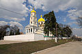
The Orthodox Saviour's Transfiguration Cathedral was constructed in 1833–1839.
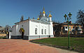
The Roman Catholic St. John the Baptist Church dates to 1812.
The St. Mary Magdalene Church was completed in 1846 by Count Branicki.
The building of a mid-19th century Great Choral Synagogue is preserved. Today it is the Technology and Economic College of Bila Tserkva National Agrarian University.
A historical landscape park Arboretum Oleksandriya of 400,67 acres is situated in Bila Tserkva. It was founded in 1793 by the wife of the Polish hetman Franciszek Ksawery Branicki.
Education
Education in Bila Tserkva is provided by many private and public institutions. The Bila Tserkva area hosts several colleges and universities, including Bila Tserkva National Agrarian University.
Activities
The city is home to football team FC Ros' Bila Tserkva. Ros is a team in the lower levels of the Football Federation of Ukraine: Kyiv Oblast Football Championship.
Industry in the city includes Railway Brake product manufacturers "Tribo Rail", Tribo plant and the major automobile tire manufacturer "Rosava".
The city is home to hockey club Bilyi Bars, that plays on Bilyi Bars Ice Arena, built by Kostyantyn Efymenko Charitable Foundation.
Famous people
- Eugene Deslaw - avant-garde French cinema director
- Luka Dolinski - Ukrainian painter, representative of the late Ukrainian Baroque, Rococo and Classicism, educated in Academy of Fine Arts Vienna
- Les Kurbas - Ukrainian movie and theater director, co-founder of Soviet theater avant-garde and a prominent figure of the Executed Renaissance
- Lyudmila Pavlichenko – World War II Soviet sniper. Credited with 309 kills, she is regarded as one of the top military snipers of all time and the most successful female sniper in history.
- David Bronstein – leading chess grandmaster and writer
- Volodymyr Dyudya – Ukrainian cyclist
- David Goodman, father of Benny Goodman – an American jazz and swing musician, clarinetist and bandleader; widely known as the "King of Swing"
- Halyna Nevinchana - Ukrainian painter, writer, journalist
- Andrzej Klimowicz – Zegota underground activist, Righteous Among the Nations
- Vadim Lazarkevich – Russian–Bulgarian illustrator
- Yuri Linnik – Soviet mathematician
- Olexandr Medvid' – famous Soviet/Belarusian wrestler.
- Yossele Rosenblatt – renowned American cantor
- Shaye Shkarovsky - Yiddish author
- Sholem Aleichem - a leading Yiddish author and playwright, the Fiddler on the Roof musical is based on his stories
- Anna Ulitko – Danish natural scientist
- Lyudmila Usherovitz (Ayzenberg Married);– Jewish gymnast
- Shmuel Yerushalmi – Israeli protest poet
- Yevgen Potocki (Semenenko) – Ukrainian/Soviet rock-musician
- Yuriy Zagorodniy – footballer
- Yaroslav Koposov – Ukrainian musician
- Kostyantyn Efymenko - president of Biofarma, Chairman of Tribo ltd
Twin towns – sister cities
 Tarnów, Poland[11]
- Ostrowiec Świętokrzyski, Poland
 Jingzhou, China
 Kaunas, Lithuania
 Noginsk, Russia
 Barysaw, Belarus
 Kremenchuk, Ukraine
Gallery
-
-

-
-

-

-
 Bila Tserkva, "Oleksandria" park, and surrounding villages in 1889
 -
![View of the so-called Ruins and the Laznevogo lake of the historical landscape park "Olexandria".[12]](//upload.wikimedia.org/wikipedia/commons/thumb/3/3c/Oleksandriia_Park_in_Bila_Tserkva.jpg/120px-Oleksandriia_Park_in_Bila_Tserkva.jpg) View of the so-called Ruins and the Laznevogo lake of the historical landscape park "Olexandria".[12]
View of the so-called Ruins and the Laznevogo lake of the historical landscape park "Olexandria".[12] -

-

-
 The Roman Catholic St. John the Baptist Church AKA The Organ and Chamber Music Hall
 -
 Square before the fall of Lenin monument in 2014
 -
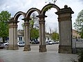 Gates of Taras Shevchenko Park
 -
 Railway station
 -
.jpg)
_3.jpg)

.JPG)


![View of the so-called Ruins and the Laznevogo lake of the historical landscape park "Olexandria".[12]](/wiki/File:Oleksandriia_Park_in_Bila_Tserkva.jpg)


._%D0%92%D1%85%D1%96%D0%B4.jpg)


See also
References
- ^ (after Kiev which is the administrative center, but not part of the oblast)
- ^ General information about the city, at Bila Tserkva official web-site
- ^ "Чисельність наявного населення України (Actual population of Ukraine)" (in Ukrainian). State Statistics Service of Ukraine. Retrieved 26 August 2017.
- ^ Paul Robert Magocsi, A history of Ukraine, University of Toronto Press, 1996, p. 205
- ^ E. A. Chernecki, L. P. Mordatenko, Bila Tserkva. Branicki family. Alexandria, Ogrody rezydencji magnackich XVIII-XIX wieku w Europie Środkowej i Wschodniej oraz problemy ich ochrony, Ośrodek Ochrony Zabytkowego Krajobrazu—Narodowa Instytucja Kultury, 2001, p.114
- ^ Marek Ruszczyc, Dzieje rodu i fortuny Branickich, Delikon, 1991, p. 148
- ^ Lucjan Blit, The origins of Polish socialism: the history and ideas of the first Polish Socialist Party 1878–1886, Cambridge University Press, 1971, p. 21
- ^ Onwar.com, Allies support resistance in Europe
- ^ Carey Schofield, Inside the Soviet Army, Headline Book Publishing, 2001, 132.
- ^ Michael Holm, 251st Instructor Heavy Bomber Aviation Regiment, accessed December 2012.
- ^ "Miasta Partnerskie". Retrieved 1 May 2014.
- ^ For more images of the park "Olexandria", see klymenko.data-tec.net
External links
- Fine and cheap hotel Kiev in the center of our city
- Four stars hotel Kiev in the center of our city
- Street Angels (UKRAINE) – Website of StreetRacers in Bila Tserkva
- Website of Bila Tserkva's patriots
- Informative Website of Bila Tserkva
- Old photos of Bila Tserkva
- Old photos of Alexandria park
- Official Bila Tserkva city webportal in Ukrainian
- Enterprise catalogue of Bila Tserkva
- Latest news in our city
- Sightseeings of Bila Tserkva
- History of Jewish Community in Belaya Tserkov