
Casa Grande Ruins National Monument
| Casa Grande Ruins National Monument | |
|---|---|
 | |
  | |
| Location | Pinal County, Arizona, USA |
| Nearest city | Coolidge |
| Coordinates | 32°59′49″N 111°31′55″W / 32.9970051°N 111.5320692°W[1] |
| Area | 472.5 acres (191.2 ha)[2] |
| Created | August 3, 1918 |
| Visitors | 62,995 (in 2018)[3] |
| Governing body | National Park Service |
| Website | Casa Grande Ruins National Monument |
| NRHP reference No. | 66000192[4] |
| Added to NRHP | October 15, 1966 |
Casa Grande Ruins National Monument (O'odham: Siwañ Waʼa Ki: or Sivan Vahki[5]), in Coolidge, Arizona, just northeast of the city of Casa Grande, preserves a group of Hohokam structures dating to the Classic Period (1150-1450 C.E.).
History of the Area
The national monument consists of the ruins of multiple structures surrounded by a compound wall constructed by the ancient people of the Hohokam period, who farmed the Gila Valley in the early 13th century. "Archeologists have discovered evidence that the ancient Sonoran Desert people who built the Casa Grande also developed wide-scale irrigation farming and extensive trade connections which lasted over a thousand years until about 1450 C.E."[6]
"Casa Grande" is Spanish for "big house" (Siwañ Wa'a Ki: in O'odham); these names refer to the largest structure on the site, which is what remains of a four-story structure that may have been abandoned by 1450. The structure is made of caliche, and has managed to survive the extreme weather conditions for about seven centuries. The large house consists of outer rooms surrounding an inner structure. The outer rooms are all three stories high, while the inner structure is four stories high. The structures were constructed using traditional adobe processes. The wet adobe is thicker at the base and adds significant strength. Noticeable horizontal cracks define the breaks between courses on the thick outer walls.[7] The process consisted of using damp adobe to form the walls and then waiting for it to dry, and then building it up with more adobe. Casa Grande contained a ball court much like that found at Pueblo Grande de Nevada. Father Eusebio Kino was the first European to view the Hohokam complex in November 1694 and named it Casa Grande.[8] Graffiti from 19th-century passers-by is scratched into its walls; though this is now illegal. Casa Grande now has a distinctive modern roof covering built in 1932.
Administrative history
In 1891, the monument underwent repairs supervised by Cosmos Mindeleff of the Bureau of American Ethnology, until funds ran out. Proclaimed Casa Grande Reservation by Executive Order 28-A of President Benjamin Harrison on June 22, 1892, Casa Grande Ruins became the first prehistoric and cultural reserve in the US. It was then re-designated a national monument by President Woodrow Wilson on August 3, 1918. As with all historical areas administered by the National Park Service, Casa Grande was listed on the National Register of Historic Places on October 15, 1966.
Historic adobes
Between 1937 and 1940 the Civilian Conservation Corps built several adobe buildings to serve as housing and administrative offices for the national monument. The adobe buildings, constructed using traditional methods, continue in use today and are now listed on the National Register of Historic Places. Because of careful conservation, the physical appearance of Casa Grande Ruins has hardly changed since the 1940s.[6]
Olmsted shelter
In 1932, a ramada to shelter the ruins from weathering was built by Boston architect Frederick Law Olmsted, Jr.[9] In the early 21st century, a pair of great horned owls took up residence in the rafters of the Olmsted shelter.[10]
The current protective structure covering the "Great House" replaced a wooden similar structure built to protect it in 1903 . Due to the fragile nature of the "Great House," visitors to the site are not permitted inside. To protect its integrity, observation by visitors is only permitted outside the structure.
Gallery
-
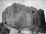 West wall of the Casa Grande ca. 1880
 -
 The east side of the Casa Grande ca. 1900
 -
 A close up view of the Big House
 -
 Doorway to the Big House.
 -
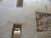 Inside the Big House.


See also
- Hohokam Pima National Monument
- Mesa Grande
- Oasisamerica cultures
- Pueblo Grande Ruin and Irrigation Sites
References
- ^ "Casa Grande Ruins National Monument". Geographic Names Information System. United States Geological Survey, United States Department of the Interior. Retrieved 2014-03-28.
- ^ "Listing of acreage – December 31, 2013" (XLSX). Land Resource Division, National Park Service. Retrieved 2012-12-27. (National Park Service Acreage Reports)
- ^ "NPS Annual Recreation Visits Report". National Park Service. Retrieved 2019-04-01.
- ^ "National Register Information System". National Register of Historic Places. National Park Service. July 9, 2010.
- ^ "History of the Gila River Water Settlement Act of 2004, Chapter 1: Roots" (PDF).
- ^ a b "Casa Grande Ruins: History & Culture". National Park Service. Retrieved 2011-06-29.
- ^ Dean R. Snow (2010). Archaeology of Native North America. Pennsylvania State University.
- ^ "An American Pompeii Unearthed in Arizona". The Washington, D.C. (p. 5). Washington, D.C. January 17, 1909 – via Newspapers.com
 .
.
- ^ "Pre-History Meets Modernity: Casa Grande Ruins National Monument". EarthArchitecture.org. Retrieved 2011-06-29.
- ^ Rotstein, Arthur H. (February 13, 2005). "Air and Ground Assaults Threaten Arizona Ruins". Los Angeles Times. Archived from the original on 2012-09-26. Retrieved 2011-06-29.
- Noble, David Grant (1995). Ancient Ruins of the Southwest'. Flagstaff, Arizona: Northland Publishing. ISBN 0-87358-530-5.
- "The National Parks: Index 2009–2011". National Park Service. Archived from the original on 2011-06-29. Retrieved 2011-06-29.
External links
- National Park Service: official Casa Grande Ruins National Monument website
- Historic American Buildings Survey (HABS) No. AZ-14, "Casa Grande (Ruins), Coolidge, Pinal County, AZ", 2 photos, 4 data pages
- Casa Grande Ruin, by Cosmos Mindeleff at Project Gutenberg
- The Repair Of Casa Grande Ruin, Arizona, in 1891, by Cosmos Mindeleff at Project Gutenberg
- "Casa Grande Ruins National Monument". Discover Our Shared Heritage: American Southwest. National Park Service. Retrieved 2011-06-29.
| Topics | |
|---|---|
| Lists by state |
|
| Lists by insular areas | |
| Lists by associated state | |
| Other areas | |
| Related | |
| International | |
|---|---|
| National | |
| Other | |
- IUCN Category III
- Buildings and structures completed in the 13th century
- National Park Service National Monuments in Arizona
- Hohokam
- Archaeological sites in Arizona
- Archaeological museums in Arizona
- Museums in Pinal County, Arizona
- Native American museums in Arizona
- Native American history of Arizona
- Archaeological sites on the National Register of Historic Places in Arizona
- Civilian Conservation Corps in Arizona
- 1918 establishments in Arizona
- Protected areas of Pinal County, Arizona
- Ruins in the United States
- 13th century in North America
- Pueblo great houses
- Casa Grande, Arizona
- Historic American Buildings Survey in Arizona
- Works Progress Administration in Arizona
- National Register of Historic Places in Pinal County, Arizona
- Ancient Puebloan archaeological sites in Arizona