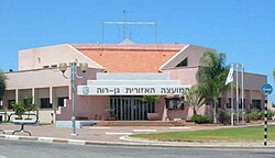
Gan Raveh Regional Council
Appearance
Gan Raveh
גן רווה | |
|---|---|
Regional council (from 1952) | |
 | |
 | |
| District | Central |
| Government | |
| • Head of Municipality | Shlomo Elimelech |
| Area | |
| • Total | 42,000 dunams (42 km2 or 16 sq mi) |
| Population (2017) | |
| • Total | 6,026 |
| • Density | 140/km2 (370/sq mi) |
| Website | Official website |
Gan Raveh Regional Council (Hebrew: מועצה אזורית גן רווה, Mo'atza Ezorit Gan Raveh) is a regional council in the Central District of Israel. The council's area of jurisdiction extends to nine settlements: a kibbutz, six moshavim, a yeshuv kehilati and a youth village. In 2017, the total population was 6,026. The council serves Ayanot, Beit Hanan, Beit Oved, Ge'alya, Gan Sorek, Irus, Kfar HaNagid, Neta'im, and Palmachim. 'Gan Raveh' means well-watered garden and these are words in a biblical verse of Isaiah,[1] which are reproduced on the signs of some of the council's villages, including Ayanot.
The head of the local council is Shlomo Elimelech.[2]
References
- ^ Isaiah 58:11: "You will be like a well-watered garden, like a spring whose waters never fail."
- ^ Coastal Crusade, Haaretz
External links
- Official website Archived 2008-02-14 at the Wayback Machine (in Hebrew)

