
Kosciuszko Road
Kosciuszko Road | |
|---|---|
 | |
| General information | |
| Type | Rural road |
| Length | 95.4 km (59 mi)[1] |
| Major junctions | |
| East end | |
| |
| West end | |
| Location(s) | |
| Major settlements | Berridale, Jindabyne |
| Restrictions | |
| General | Within Kosciuszko National Park, it is compulsory for two-wheel drive vehicles to carry snow chains between the June and October long weekends.[2] |
The Kosciuszko Road is a road in the Snowy Mountains of New South Wales, Australia which runs from Pine Valley, to the ski resort of Charlotte Pass. It passes through the towns of Berridale and Jindabyne before entering Kosciuszko National Park. Within the national park it provides access to Smiggin Holes and Perisher Valley and Charlotte Pass ski resorts, and terminates just past the entry to the latter.
Gallery
-
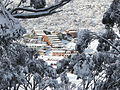 Charlotte Pass Ski Resort from the Kosciuszko Road in winter.
 -
 Perisher, Australia's largest ski resort, can be accessed via the Kosciuszko Road.
 -
 Statue of Sir Paul Strzelecki in the Snowy Mountains town of Jindabyne.


See also
References
- ^ "Kosciuszko Road" (Map). Google Maps. Retrieved 27 July 2013.
- ^ "Driving in the snow". NSW Government - Office of Environment and Heritage. 19 July 2011. Retrieved 27 July 2013.
This Australian road or road transport-related article is a stub. You can help Wikipedia by expanding it. |