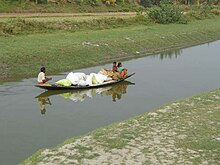
Jamuna River (West Bengal)
| Jamuna River | |
|---|---|
 River Jamuna at Charghat | |
| Location | |
| Country | India |
| State | West Bengal |
| District | North 24 Parganas, Nadia |
| Physical characteristics | |
| Source | Hooghly River |
| • location | West Bengal, India |
| Mouth | Ichamati River |
• location | West Bengal, India |
Jamuna River is a tributary of the Ichamati River. It flows through the Indian state of West Bengal and is one of the major rivers of the North 24 Parganas district. Till the 17th century, the Jamuna originated as a distributary of the Hooghly River separating from it near Tribeni, along with the Saraswati River , hence giving the town its name. Unlike the Saraswati that flowed southwest from Tribeni, the Jamuna used to flow eastwards, along the northern borders of the present day town of Kalyani and the region around the Indian Institute of Science Education and Research, Kolkata, Nagarukhra in the Nadia district, then enter the North 24 Parganas district and finally merge with the Ichamati River. From the 18th century onwards, the Padma river emerged as the main distributary of the Ganga. Reduction of the waters in the Hooghly and silting up of the upper reaches of the Jamuna, resulted in it being totally cut off from the Hooghly river. The Jamuna is now an independent rain fed channel that emerges south-east of the Nadia district and empties itself into the Ichamati river.
References
26°06′N 92°45′E / 26.100°N 92.750°E
