
Aouste
Aouste | |
|---|---|
 | |
 Coat of arms | |
Location of Aouste  | |
 Aouste  Aouste | |
| Coordinates: 49°47′54″N 4°18′59″E / 49.7983°N 4.3164°E | |
| Country | France |
| Region | Grand Est |
| Department | Ardennes |
| Arrondissement | Charleville-Mézières |
| Canton | Signy-l'Abbaye |
| Intercommunality | Thiérache Ardennaise |
| Government | |
| • Mayor (2008–2020) | Xavier Coffart |
| Area 1 | 12.83 km2 (4.95 sq mi) |
| Population (2021)[1] | 209 |
| • Density | 16/km2 (42/sq mi) |
| Time zone | UTC+01:00 (CET) |
| • Summer (DST) | UTC+02:00 (CEST) |
| INSEE/Postal code | 08016 /08290 |
| Elevation | 187–289 m (614–948 ft) (avg. 205 m or 673 ft) |
| 1 French Land Register data, which excludes lakes, ponds, glaciers > 1 km2 (0.386 sq mi or 247 acres) and river estuaries. | |
Aouste is a commune in the Ardennes department in the Grand Est region of northern France.
The inhabitants of the commune are known as Aoustiens or Aoustiennes[2]
Geography
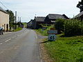
Aouste is located some 35 km south-east of Hirson and 40 km west by north-west of Charleville-Mézières. Access is by the D36 road from La Férée in the south passing through the village then continuing east to Prez. The D27 road also comes from Rumigny in the west passing through the commune south of the village and continuing to Marlemont in the south-east. A railway from Hirson to Charleville-Mezieres passes through the commune with a station at Liart just outside the commune to the south-east. Apart from the village the commune is mostly farmland with a few patches of forest.
The Aube river passes through the commune from the east and flows through the village before continuing west to join the Ton at Hannappes. The Ruisseau de Laval d'Estrebay flows from the north forming part of the northern border to join the Aube on the western border. There is also the Ruisseau du Moulin Veron which flows from the south joining the Aube near the village. The Ruisseau de Gandlu flows from the south-east joining the Aube in the village.[3]
Neighbouring communes and villages[3]
Places adjacent to Aouste | |
|---|---|
Heraldry
|
Blazon: Argent, a lion of Sable, in chief a bar embattled-counter-embattled of Gules, the whole bordure in Vert.
|
Administration
List of Successive Mayors[4]
| From | To | Name | Party | Position |
|---|---|---|---|---|
| 1995 | 2020 | Xavier Coffart | UMP | General Councillor (1998-2004) |
(Not all data is known)
Demography
In 2009 the commune had 202 inhabitants. The evolution of the number of inhabitants is known from the population censuses conducted in the commune since 1793. From the 21st century, a census of communes with fewer than 10,000 inhabitants is held every five years, unlike larger towns that have a sample survey every year.[Note 1]
Template:Table Population Town

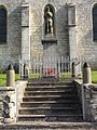
Sites and monuments

.
The fortified Church of Saint-Rémi (15th century) is registered as an historical monument.![]() [5]
[5]
Aouste Picture Gallery
-
 Aouste Lavoir
 -
 Aouste Town Hall
 -
 The War Memorial
 -
 Chapel of Saint Philomene
 -
 Entrance to the village
 -
 Wayside Cross at Aouste
_lavoir.JPG)
_mairie.JPG)
_Monument_aux_morts.JPG)
_chapelle_Ste_Philom%C3%A8ne.JPG)
_city_limit_sign.JPG)
_Paysage_avec_croix_de_chemin.JPG)
See also
External links
- Aouste on the National Geographic Institute website (in French)
- Aouste on Lion1906
- Aouste on Google Maps
- Aouste on Géoportail, National Geographic Institute (IGN) website (in French)
- Aoufte on the 1750 Cassini Map
- Aouste on the INSEE website (in French)
- INSEE (in French)
Notes and references
Notes
- ^ At the beginning of the 21st century, the methods of identification have been modified by Law No. 2002-276 of 27 February 2002 Archived 6 March 2016 at the Wayback Machine, the so-called "law of local democracy" and in particular Title V "census operations" allows, after a transitional period running from 2004 to 2008, the annual publication of the legal population of the different French administrative districts. For communes with a population greater than 10,000 inhabitants, a sample survey is conducted annually, the entire territory of these communes is taken into account at the end of the period of five years. The first "legal population" after 1999 under this new law came into force on 1 January 2009 and was based on the census of 2006.
References
- ^ "Populations légales 2021" (in French). The National Institute of Statistics and Economic Studies. 28 December 2023.
- ^ Inhabitants of Ardennes (in French)
- ^ a b Google Maps
- ^ List of Mayors of France
- ^ Ministry of Culture, Mérimée PA00078332 Church of Saint-Rémi (in French)