
Polanów
Polanów | |
|---|---|
 | |
 Coat of arms | |
 Polanów | |
| Coordinates: 54°6′N 16°42′E / 54.100°N 16.700°E | |
| Country | |
| Voivodeship | West Pomeranian |
| County | Koszalin |
| Gmina | Polanów |
| Town rights | 1313 |
| Government | |
| • Mayor | Grzegorz Paweł Lipski[1] |
| Area | |
• Total | 7.61 km2 (2.94 sq mi) |
| Population (2017[1]) | |
• Total | 2,949 |
| • Density | 390/km2 (1,000/sq mi) |
| Time zone | UTC+1 (CET) |
| • Summer (DST) | UTC+2 (CEST) |
| Postal code | 76-010 |
| Area code | +48 94 |
| Vehicle registration | ZKO |
| Website | http://www.polanow.pl |
Polanów [pɔˈlanuf] (Template:Lang-de) is a town in northern Poland, located in the Koszalin County of the West Pomeranian Voivodeship. It has 2,949 inhabitants (2017).
History
The settlement was first mentioned in 13th century, and was granted town rights in 1313[1] under Lübeck law.
The town was completely destroyed during World War II.
Points of interest
- Gołogóra transmitter, a facility for FM-/TV-broadcasting with 2 guyed masts, which are 271 respectively 115 metres tall
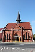
- Historic churches: Church of the Assumption, Exaltation of the Holy Cross church
- Zalew Polanowski (artificial lake)
- Historical watermill complex
-
 Church of the Assumption
 -
 Exaltation of the Holy Cross church
 -
 Zalew Polanowski


Town twinning
Polanów is twinned with:[2]
 Gedern, Germany
- Rothenklempenow, Germany
Notable People
- Julius Leopold Pagel (1851–1912) a German physician and historian of medicine.
References
- ^ a b c "Polanów (zachodniopomorskie)". Polska w liczbach (in Polish). Retrieved 29 October 2019.
- ^ "Miasta partnerskie". Polanów.pl (in Polish). Retrieved 29 October 2019.
External links
Wikimedia Commons has media related to Polanów.
54°06′N 16°42′E / 54.100°N 16.700°E
| International | |
|---|---|
| National | |
| Geographic | |
This West Pomeranian Voivodeship location article is a stub. You can help Wikipedia by expanding it. |