Stansbury, South Australia
| Stansbury South Australia | |||||||||||||||
|---|---|---|---|---|---|---|---|---|---|---|---|---|---|---|---|
 Dalrymple Hotel at Stansbury | |||||||||||||||
| Coordinates | 34°55′0″S 137°47′0″E / 34.91667°S 137.78333°E | ||||||||||||||
| Population | 648 (2016 census)[1] | ||||||||||||||
| Established | 1873 | ||||||||||||||
| Postcode(s) | 5582 | ||||||||||||||
| Time zone | ACST; UTC+09:30 (UTC) | ||||||||||||||
| Location | |||||||||||||||
| LGA(s) | Yorke Peninsula Council | ||||||||||||||
| State electorate(s) | Narungga[2] | ||||||||||||||
| Federal division(s) | Grey | ||||||||||||||
| |||||||||||||||
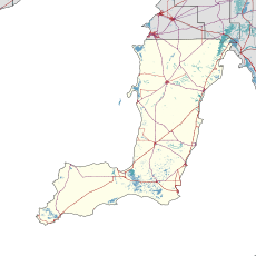
Stansbury (postcode 5582) is a small town, located in the southern east coast of Yorke Peninsula, South Australia. At the 2016 census, Stansbury had a population of 648 people.[1] It is located 25 kilometres (16 mi) south of Minlaton and 22 kilometres (14 mi) east of Yorketown. It faces the Gulf St Vincent across Oyster Bay, where shellfish were originally harvested in the 19th century. The town has also been a port used in the export of wheat and barley to Adelaide.[4]
History
The town was originally known as Oyster Bay, although it was officially proclaimed Stansbury in 1873 by Governor Anthony Musgrave, in honour of a friend.
In 2009, Stansbury was voted as South Australia's tidiest town.[5]
Economy
The town was used heavily as a port in past times, predominantly in the export of wheat and barley to Adelaide.[4] The local economy is still dominated by broadacre cereal cropping.[citation needed]
Dalrymple substation
Dalrymple electrical substation is located at Hayward Corner in the locality of Stansbury, just south of the township. Its name is based on the Hundred of Dalrymple, the cadastral division in which Stansbury lies.
Dalrymple substation is at the end of a 275kV power line into the peninsula. It feeds 33kV lines to various towns across the lower end of the peninsula and receives electricity generated by the Wattle Point Wind Farm.
The Dalrymple ESCRI battery was completed in January 2019 adjacent to the substation.
Market
As of 2018[update], from mid-autumn to mid-spring, the Stansbury seaside market is held about once a month on Saturday mornings on the foreshore. The country-style market was the first of its kind to be established on Yorke Peninsula region.[6]
Facilities
The beach at Stansbury offers a permanently moored pontoon, and VAC swim operates out of this location in the summer school holidays.[7]
The town has two caravan parks, as well as two holiday motels and a hotel in the center of town.
Three main locations for dining in the town are Wild Ma's Bistro, The Dalrymple Hotel, and the Blue Lime Cafe and Deli.
See also
References
- ^ a b Australian Bureau of Statistics (27 June 2017). "Stansbury (L) (Urban Centre/Locality)". 2016 Census QuickStats. Retrieved 6 January 2019.
- ^ Narungga (Map). Electoral District Boundaries Commission. 2016. Retrieved 1 March 2018.
- ^ a b c d e f g h "New Ward Structure 2014". Yorke Peninsula Council. Archived from the original on 15 January 2016. Retrieved 21 October 2015.
- ^ a b South Australia Cities and Towns, 1st Edition. UBD (A Division of Universal Press Pty Ltd). 1995. ISBN 0-7319-0636-5.
- ^ AUSTRALIAN TIDY TOWNS HONOUR ROLL. Keep Australia Beautiful. Retrieved 6 January 2019.
- ^ "Stansbury Seaside Markets". Stansbury Progress Association Incorporated. Retrieved 6 January 2019.
- ^ Stansbury Beach VACSWIM SA

