Pirkanmaa
Appearance
Pirkanmaa
Pirkanmaan maakunta landskapet Birkaland | |
|---|---|
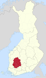
 Pirkanmaa on a map of Finland | |
| Coordinates: 61°42′N 23°43′E / 61.700°N 23.717°E | |
| Country | Finland |
| Historical province | Satakunta, Tavastia |
| Capital | Tampere |
| Area | |
| • Total | 14,469.39 km2 (5,586.66 sq mi) |
| Population (2019) | |
| • Total | 517,666 |
| • Density | 36/km2 (93/sq mi) |
| Time zone | UTC+2 (EET) |
| • Summer (DST) | UTC+3 (EEST) |
| ISO 3166 code | FI-11 |
| NUTS | 192 |
| Regional bird | White wagtail (Motacilla alba) |
| Regional fish | Asp (Aspius aspius) |
| Regional flower | Bird cherry (Prunus padus) |
| Website | pirkanmaa.fi |
Pirkanmaa (Swedish: Birkaland, also known as Tampere Region in government documents[1]), is a region of Finland. It borders the regions of Satakunta, South Ostrobothnia, Central Finland, Päijät-Häme, Kanta-Häme and Southwest Finland. Its total population is the second largest among Finland's regions after Uusimaa.
Historical provinces
Municipalities

The region of Pirkanmaa is made up of 22 municipalities, of which 12 have city status (marked in bold).
|
North Western Pirkanmaa sub-region:
Upper Pirkanmaa sub-region:
|
Southern Pirkanmaa sub-region:
South Western Pirkanmaa sub-region:
|
Tampere sub-region:
|
Politics
Results of the 2019 Finnish parliamentary election in Pirkanmaa:
- Social Democratic Party 22.10%
- National Coalition Party 18.47%
- Finns Party 17.32%
- Green League 12.42%
- Centre Party 8.87%
- Left Alliance 8.14%
- Christian Democrats 5.74%
- Movement Now 2.40%
- Blue Reform 1.12%
- Seven Star Movement 0.46%
- Swedish People's Party 0.11%
- Other parties 2.85%
See also
References
- ^ "Welcome to the Tampere Region". Council of Tampere Region. Archived from the original on 2015-11-25. Retrieved 2013-06-20.
External links
Wikimedia Commons has media related to Pirkanmaa.


