Mattancherry
Mattancherry
Cochim de Cima (Upper Kochi) | |
|---|---|
Neighbourhood | |
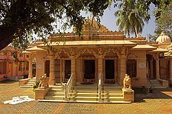
 Dharmanath Jain Temple of Mattancherry | |
| Coordinates: 9°57′45″N 76°15′15″E / 9.96250°N 76.25417°E | |
| Country | India |
| State | Kerala |
| District | Ernakulam |
| Languages | |
| • Official | Malayalam, English |
| Time zone | UTC+5:30 (IST) |
| PIN | 682002 |
| Vehicle registration | KL-43 |
Mattancherry is a locality in the city of Kochi, India. It is about 9 km south-west from the city center. It is said that the name Mattancherry comes from "Ancherry Mattom", a ''Namboodiri illam'' which the foreign traders then pronounced it as Matt-Ancherry, gradually became Mattancherry. The place where erstwhile 'Ancherry Mattom' located is now a Tamil Brahmin settlement.
Politics
Mattancherry is a part of the Kochi assembly constituency & Ernakulam (Lok Sabha constituency).[1]
Notable sights
Mattancherry is home to the Paradesi Synagogue, India's oldest functioning synagogue,[2] Mattancherry Palace Museum, Mattacherry Pazhayannur Royal temple.
Gallery
-
International Tourism Police Museum at Mattancherry
-
Traditional Mattancherry Sweets Gujarathi
-
The St. George Orthodox Koonan Kurish Old Syrian Church at Mattancherry
References
- ^ "Assembly Constituencies - Corresponding Districts and Parliamentary Constituencies" (PDF). Kerala. Election Commission of India. Archived from the original (PDF) on 4 March 2009. Retrieved 19 October 2008.
- ^ Abram, David. The Rough Guide to Kerala (2nd ed.). London, United Kingdom: Penguin Books. p. 181. ISBN 978-1-84836-541-4.|
External links
 Media related to Mattancherry at Wikimedia Commons


