
Paoay
Paoay | |
|---|---|
| Municipality of Paoay | |
 Paoay Church | |
 Seal | |
 Map of Ilocos Norte with Paoay highlighted | |
OpenStreetMap  | |
.svg) Paoay Location within the Philippines | |
| Coordinates: 18°03′45″N 120°31′13″E / 18.0625°N 120.5203°E | |
| Country | |
| Region | Ilocos Region |
| Province | Ilocos Norte |
| District | 2nd District |
| Barangays | 31 (see Barangays) |
| Government | |
| • Type | Sangguniang Bayan |
| • Mayor | Jessie E. Galano |
| • Vice Mayor | Romulo L. Acdal |
| • Congressman | Eugenio Angelo M. Barba |
| • Electorate | 17,543 voters (2022) |
| Area | |
| • Total | 76.24 km2 (29.44 sq mi) |
| Elevation | 20 m (70 ft) |
| Population (2020 census)[3] | |
| • Total | 25,001 |
| • Density | 330/km2 (850/sq mi) |
| • Households | 6,233 |
| Economy | |
| • Income class | 4th municipal income class |
| • Poverty incidence | 8.44% (2015)[4] |
| • Revenue (₱) | ₱ 130.8 million (2020) |
| • Assets (₱) | ₱ 587.8 million (2020) |
| • Liabilities (₱) | ₱ 212.7 million (2020) |
| • Expenditure (₱) | ₱ 94.23 million (2020) |
| Time zone | UTC+8 (PST) |
| ZIP code | 2902 |
| PSGC | |
| IDD : area code | +63 (0)77 |
| Native languages | Ilocano Tagalog |
Paoay, officially the Municipality of Paoay (Template:Lang-ilo; Filipino: Bayan ng Paoay), is a 4th class municipality in the province of Ilocos Norte, Philippines. According to the 2020 census, it has a population of 25,001 people.[3]
The town is home to the Paoay Church, a UNESCO World Heritage Site.
Barangays
Paoay is politically subdivided into 31 barangays. [2]
- Bacsil
- Cabagoan
- Cabangaran
- Callaguip
- Cayubog
- Dolores
- Laoa
- Masintoc
- Monte
- Mumulaan
- Nagbacalan
- Nalasin
- Nanguyudan
- Oaig-Upay-Abulao
- Pambaran
- Pannaratan (Poblacion)
- Paratong
- Pasil
- Salbang (Poblacion)
- San Agustin
- San Blas (Poblacion)
- San Juan
- San Pedro
- San Roque (Poblacion)
- Sangladan Pob. (Nalbuan)
- Santa Rita (Poblacion)
- Sideg
- Suba
- Sungadan
- Surgui
- Veronica
Demographics
| Year | Pop. | ±% p.a. |
|---|---|---|
| 1903 | 12,743 | — |
| 1918 | 16,639 | +1.79% |
| 1939 | 11,867 | −1.60% |
| 1948 | 11,257 | −0.58% |
| 1960 | 13,189 | +1.33% |
| 1970 | 15,218 | +1.44% |
| 1975 | 15,994 | +1.00% |
| 1980 | 17,016 | +1.25% |
| 1990 | 20,680 | +1.97% |
| 1995 | 21,253 | +0.51% |
| 2000 | 21,745 | +0.49% |
| 2007 | 23,117 | +0.85% |
| 2010 | 23,956 | +1.31% |
| 2015 | 24,866 | +0.71% |
| Source: Philippine Statistics Authority[5][6][7][8] | ||
In the 2020 census, the population of Paoay was 25,001 people,[3] with a density of 330 inhabitants per square kilometre or 850 inhabitants per square mile.
Paoay Lake
Another prominent feature of the municipality is Paoay Lake. Legend has it that it was the site of a prosperous barangay called San Juan de Sahagún (Saint John of Sahagún) that sank following an earthquake.[9]
On the shores of the lake lies a mansion once used by the Marcoses called Malacañang of the North; it is now a museum. Adjacent to the mansion is the Paoay Golf Course.
Climate
| Climate data for Paoay, Ilocos Norte | |||||||||||||
|---|---|---|---|---|---|---|---|---|---|---|---|---|---|
| Month | Jan | Feb | Mar | Apr | May | Jun | Jul | Aug | Sep | Oct | Nov | Dec | Year |
| Mean daily maximum °C (°F) | 31 (88) |
32 (90) |
33 (91) |
34 (93) |
34 (93) |
34 (93) |
33 (91) |
32 (90) |
32 (90) |
33 (91) |
32 (90) |
31 (88) |
33 (91) |
| Mean daily minimum °C (°F) | 19 (66) |
20 (68) |
21 (70) |
23 (73) |
24 (75) |
24 (75) |
24 (75) |
24 (75) |
24 (75) |
23 (73) |
22 (72) |
21 (70) |
22 (72) |
| Average rainfall mm (inches) | 6.2 (0.24) |
11.7 (0.46) |
10.1 (0.40) |
14 (0.6) |
192.7 (7.59) |
258.9 (10.19) |
470.9 (18.54) |
475.9 (18.74) |
405.7 (15.97) |
92.5 (3.64) |
44.8 (1.76) |
3 (0.1) |
1,986.4 (78.23) |
| Average rainy days | 3 | 2 | 2 | 2 | 12 | 15 | 20 | 20 | 17 | 10 | 6 | 3 | 112 |
| Source: World Weather Online[10] | |||||||||||||
Gallery
-
 View of Paoay poblacion
 -
 Buttress of the Paoay Church
 -
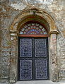 details on the side of a door of the church


References
- ^ Municipality of Paoay | (DILG)
- ^ a b "Province: Ilocos Norte". PSGC Interactive. Quezon City, Philippines: Philippine Statistics Authority. Retrieved 12 November 2016.
- ^ a b c Census of Population (2020). "Region I (Ilocos Region)". Total Population by Province, City, Municipality and Barangay. Philippine Statistics Authority. Retrieved 8 July 2021.
- ^ "PSA releases the 2015 Municipal and City Level Poverty Estimates". Quezon City, Philippines. Retrieved 1 January 2020.
- ^ Census of Population (2015). "Region I (Ilocos Region)". Total Population by Province, City, Municipality and Barangay. Philippine Statistics Authority. Retrieved 20 June 2016.
- ^ Census of Population and Housing (2010). "Region I (Ilocos Region)" (PDF). Total Population by Province, City, Municipality and Barangay. National Statistics Office. Retrieved 29 June 2016.
- ^ Censuses of Population (1903–2007). "Region I (Ilocos Region)". Table 1. Population Enumerated in Various Censuses by Province/Highly Urbanized City: 1903 to 2007. National Statistics Office.
- ^ "Province of Ilocos Norte". Municipality Population Data. Local Water Utilities Administration Research Division. Retrieved 17 December 2016.
- ^ Hargrove, Thomas R. (1991). "The Mysteries of Taal: A Philippine volcano and lake, her sea life and lost towns", p.135. Bookmark, Manila. ISBN 971-569-046-7.
- ^ "Paoay, Philippines: Average Temperatures and Rainfall". World Weather Online. Retrieved 15 September 2014.
External links
- Official website
- Paoay Profile at PhilAtlas.com
- Philippine Standard Geographic Code
- Philippine Census Information
- Local Governance Performance Management System
Places adjacent to Paoay | |
|---|---|
Laoag (capital and largest city) | |
| Municipalities | |
| Component cities | |
| Barangays | |