Kingsclear Parish, New Brunswick
Appearance
Kingsclear | |
|---|---|
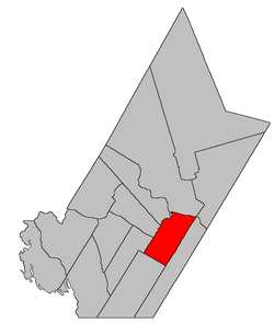
 Location within York County, New Brunswick. | |
| Coordinates: 45°53′06″N 66°54′27″W / 45.885°N 66.9075°W | |
| Country | |
| Province | |
| County | York |
| Established | 1786 |
| Area | |
| • Land | 303.38 km2 (117.14 sq mi) |
| Population (2016)[1] | |
| • Total | 7,572 |
| • Density | 24.96/km2 (64.6/sq mi) |
| • Change 2011-2016 | |
| • Dwellings | 2,925 |
| Kingsclear Parish including RC of Hanwell | |
| Time zone | UTC-4 (AST) |
| • Summer (DST) | UTC-3 (ADT) |
Kingsclear is a civil parish[a] in York County, New Brunswick, Canada.[2]
For governance purposes it is divided between the city of Fredericton, the Indian reserve of Kingsclear 6, the incorporated rural community of Hanwell,[3], and the local service district of the parish of Kingsclear,[4] which further includes the special service area of Oswald Gray.
Delineation
Kingsclear Parish was defined in the Territorial Division Act[2] as being bounded:
- North by the Saint John River; southeast by the City of Fredericton and New Maryland Parish; southwest by Manners Sutton Parish, and northwest by the lower line of lot numbered one, granted to Francis Horsman, and its southwesterly prolongation, including all the islands in front, with the exception of Upper Shores, Lower Shores, Mitchells, Merrithews and Keswick Islands, and the north range of lots, comprising lots number one to number nine inclusive, and lots number thirty-seven to number seventy-one inclusive, on Sugar Island, which form part of the Parish of Douglas.
Communities
Parish population total does not include incorporated municipalities (in bold):
|
|
Demographics
Population
|
LanguageMother tongue language (2006)[8]
|
See also
Notes
- ^ Civil parishes served a variety of government functions until 1966, when the new Municipalities Act stripped them of their responsibilities; they continue to provide convenient boundaries for government uses, especially electoral districts and local service districts. Statistics Canada uses civil parishes as census subdivisions for all parts of the province that are not within municipalities and similar entities.
- ^ The 2011 population count of the LSD was only 2,947[7] and the rural community had the same boundaries as the LSD.
References
- ^ a b c "Census Profile, 2016 Census Kingsclear, Parish [Census subdivision], New Brunswick and Hanwell, Rural community [Census subdivision], New Brunswick". Statistics Canada. Retrieved October 8, 2019.
- ^ a b "Chapter T-3 Territorial Division Act". Government of New Brunswick. Retrieved 25 July 2020.
- ^ "New Brunswick Regulation 2014-30 under the Municipalities Act (O.C. 2014-81)". Government of New Brunswick. Retrieved 25 July 2020.
- ^ "New Brunswick Regulation 84-168 under the Municipalities Act (O.C. 84-582)". Government of New Brunswick. Retrieved 25 July 2020.
- ^ Statistics Canada: 1996, 2001, 2006 census
- ^ 2011 Statistics Canada Census Profile: Kingsclear Parish, New Brunswick
- ^ "Hanwell LSD Census Profile". Statistics Canada. Retrieved 25 July 2020.
- ^ 2006 Statistics Canada Community Profile: Kingsclear Parish, New Brunswick
External links
- City of Fredericton
- Hanwell Rural Community
- Kingsclear Local Service District
- Upper Kingsclear community
- York Rural Community Project
