Skopska Crna Gora
Appearance
| Skopska Crna Gora | |
|---|---|
| Macedonian and Template:Lang-sr, Skopska Crna Gora Template:Lang-sq Template:Lang-tr | |
 | |
| Highest point | |
| Peak | Ramno |
| Elevation | 1,651 m (5,417 ft) |
| Coordinates | 42°11′24″N 21°26′24″E / 42.19000°N 21.44000°E |
| Naming | |
| Native name | Скопска Црна Гора Error {{native name checker}}: parameter value is malformed (help) |
| Geography | |
Location of the mountain within North Macedonia | |
| Location | North Macedonia, Kosovo and Serbia |
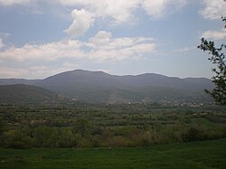
Skopska Crna Gora (Macedonian and Serbian Cyrillic: Скопска Црна Гора, pronounced [skôpskaː tsr̩̂ːnaː ɡǒra], Template:Lang-sq; meaning "Black Mountain of Skopje"), often called and only as Crna Gora (Macedonian and Serbian Cyrillic: Црна Гора, Albanian: Mali i Zi; meaning "Black Mountain"), Albanian: Malet e Karadakut), is a mountain range largely in North Macedonia, with smaller parts in Kosovo[a] and Serbia. It lies between the cities of Kaçanik (in southern Kosovo) and Skopje (in Macedonia). The highest peak is Ramno (1,651 m (5,417 ft)) in Macedonia.[1] The largest town on the mountain is Kučevište in North Macedonia.[1]
The Macedonian population of the region speaks the Skopska Crna Gora dialect of the Macedonian language.
Notable people
Culture
- Monastery of St. Nikita, dating to the 14th century, with frescoes by Mihajlo and Eftihie.
See also
References and notes
- Notes
- References
Sources
Wikimedia Commons has media related to Skopska Crna Gora.
- "Skopska Crna Gora", Srpski etnografski zbornik, VI, Belgrade, 1905


