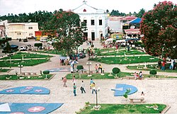
Aporá
Aporá | |
|---|---|
| Município de Aporá Municipality of Aporá | |
 The main square. | |
| Nickname: A'Porã | |
 Location of Aporá in the State of Bahia | |
| Country | |
| Region | Northeast |
| State | |
| Founded | 14 August 1958 |
| Elevation | 186 m (610 ft) |
| Population | |
| • Total | 17 085 |
| Time zone | UTC-3 |
| Postal Code | 48350-000 |
| Area code | +55 75 |
Aporá is a municipality in the state of Bahia in the North-East region of Brazil.[1][2][3][4]
The city population was 17 085 and its area is 572 km² (29.36 inhabitants per km²) according to the 2002 census. Aporá was emancipated from the municipality of Inhambupe on 14 August 1958 by municipal Resolution 89, and Aporá was created by Resolution 1021, signed on the same date.
To the north it is bordered by Crisópolis, to the south and west by Inhambupe, to the east by Esplanada, the northeast by Acajutiba, the northwest by Olindina and the southeast by Entre Rios.
Folklore
Two books recounting histories, legends and stories about Aporá have been published. One was a work written by the pupils of the city's Golden College, titled "Basic Information on Aporá", and the other is called "Ao Lusco Fusco" (At Twilight), from author Selma Oliveira de Mendonça, in which she describes the origins of the name "Aporá" and presents traditional legends and customs of the city. A famous legend in the local folklore is the "Serpent of the Lagoon", the story of a newborn rejected by its mother, who throws it in a lagoon, and later summoned by a priest to come out of the waters, raising instead as a fire-breathing serpent that attacks the neglectful mother.
References
- ^ "Divisão Territorial do Brasil" (in Portuguese). Divisão Territorial do Brasil e Limites Territoriais, Instituto Brasileiro de Geografia e Estatística (IBGE). 1 July 2008. Retrieved 17 December 2009.[permanent dead link]
- ^ "Estimativas da população para 1º de julho de 2009" (PDF) (in Portuguese). Estimativas de População, Instituto Brasileiro de Geografia e Estatística (IBGE). 14 August 2009. Retrieved 17 December 2009.
- ^ "Ranking decrescente do IDH-M dos municípios do Brasil" (in Portuguese). Atlas do Desenvolvimento Humano, Programa das Nações Unidas para o Desenvolvimento (PNUD). 2000. Archived from the original on 3 October 2009. Retrieved December 17, 2009.
{{cite web}}: Unknown parameter|deadurl=ignored (|url-status=suggested) (help) - ^ "Produto Interno Bruto dos Municípios 2002-2005" (PDF) (in Portuguese). Instituto Brasileiro de Geografia e Estatística (IBGE). 19 December 2007. Archived from the original (PDF) on 2 October 2008. Retrieved December 17, 2009.
{{cite web}}: Unknown parameter|deadurl=ignored (|url-status=suggested) (help)


