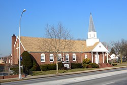
Bellerose, Queens
Bellerose | |
|---|---|
 Church on Hillside Avenue | |
 | |
| Country | United States |
| State | New York |
| County | Queens |
| ZIP code | 11426 |
| Area code(s) | 718, 347, 917 |
Bellerose is a middle class neighborhood on the eastern edge of the New York City borough of Queens, along the border of Queens and Nassau County, Long Island. It is adjacent to Bellerose village and Bellerose Terrace in Nassau County, from which it is separated by Jericho Turnpike. The neighborhood is part of Queens Community Board 13.[1] The northern edge of Bellerose is separated from another part of the Nassau border by the neighborhood of Floral Park, Queens to the east, divided by Little Neck Parkway. The neighborhood consists predominantly of detached houses with a mostly Indian American, European American, and working and middle class populations. While the northeastern section of Queens Village is sometimes referred to as part of Bellerose, it is also called Bellerose Manor, which is recognized by the U.S. Postal Service as an "acceptable alternate" to Queens Village and Jamaica in postal addresses.[2]
Bellerose's public schools are operated by the New York City Department of Education. It is mostly part of District 26 but some areas are in District 29. The neighborhood's nearest high school is Martin Van Buren High School in Queens Village. Also, the Queens Borough Public Library operates the Bellerose Branch.
New York City Bus serve Floral Park on the Q43, the Q46, the Q36 on Little Neck Parkway on weekdays, and the X68. It is also served by Nassau Inter-County Express on the n22, n22L, n22A. Hillside Avenue, Jamaica Avenue, and Union Turnpike and the three major east-west arteries. The closest railway station is the Bellerose station, located outside the city limits on the Hempstead Branch of the Long Island Rail Road.
Notable people
- Shannon Tavarez – Broadway actress; advocate for bone-marrow donation.
- Evan Handler – actor
References
- ^ Queens Community Boards, New York City. Accessed September 3, 2007.
- ^ Bellerose Manor: In a Tale of Pride and ZIP Codes, One Digit Makes All the Difference, The New York Times, September 14, 2003; accessed December 21, 2011

