Blacko
This article needs additional citations for verification. (October 2013) |
| Blacko | |
|---|---|
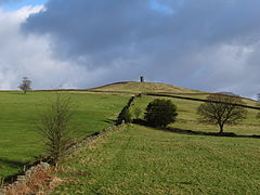
 A view of Blacko Tower taken from the top of the village in early winter | |
| Population | 672 (2011) |
| OS grid reference | SD856415 |
| Civil parish |
|
| District | |
| Shire county | |
| Region | |
| Country | England |
| Sovereign state | United Kingdom |
| Post town | NELSON |
| Postcode district | BB9 |
| Dialling code | 01282 |
| Police | Lancashire |
| Fire | Lancashire |
| Ambulance | North West |
| UK Parliament | |
Blacko is a village and civil parish in the Pendle district of Lancashire, England. Before local government reorganisation in 1974 the village lay on the border with the West Riding of Yorkshire. The parish has a population of 672.[1] The village is on the old turnpike road from Nelson to Gisburn (A682). The village enjoys views towards Boulsworth Hill to its southeast, the former cotton town of Nelson, about two miles to its south and Pendle Hill to its west across the valley of Pendle Water.
The parish adjoins the Pendle parishes of Middop, Bracewell and Brogden, Salterforth, Foulridge, Colne, Barrowford, Roughlee Booth and Barley-with-Wheatley Booth. Parts of the parish, west of the village are included in the Forest of Bowland Area of Outstanding Natural Beauty (AONB).[2]
Overlooking the village is Stansfield Tower (also known as Blacko Tower), which was built around 1890. A local grocer, Jonathan Stansfield, built this circular rough stone tower to provide himself with a view over Ribblesdale from the top, but the height fell somewhat short.[3] A Bronze Age axe, believed to be 3,500 years old, was found near the tower in 1952.[4]
The village has won the small village category of the Lancashire Best Kept Village competition in 2002 and 07, and the champion village category in 2011, 13, and 14.[5][6][7]
The part of Blacko parish historically in Lancashire was once part of Barrowford township in the ancient parish of Whalley. This became a civil parish in 1866, however in 1894 the urban areas became and urban district and Blacko was created from the remainder, forming part of the Burnley Rural District until 1974.[8] Along with part of Barrowford, the parish forms the Blacko and Higherford ward of Pendle Borough Council.[9]
According to the United Kingdom Census 2011, the parish has a population of 672,[1] an increase from 595 in the 2001 census.[10]
Blacko was the childhood home of Lancashire comedian Jimmy Clitheroe (1921–73), famous for his BBC radio series The Clitheroe Kid, who lived there from 1922 to 1935. Jimmy went to school in Blacko and appeared in many amateur concert party entertainments in the village's Methodist chapel, before turning professional in 1936.
Also during the 1930s it was the home of the comedian Tommy Trafford, who played many summer seasons in the Lancashire seaside resort of Southport between the 1960s and '80s, resulting in his nickname of Mr Southport.
See also
References
Citations
- ^ a b "Key Figures for 2011 Census: Key Statistics". Office for National Statistics. Retrieved 1 July 2015.
- ^ Forest of Bowland map (Map). forestofbowland.com. Lancashire County Council.
- ^ Clayton (2007), pp. 266–7
- ^ Historic England. "Monument No. 45476 (45476)". Research records (formerly PastScape). Retrieved 5 September 2015.
- ^ Magill, Peter (15 September 2011). "Pendle and Ribble Valley joy in best-kept village awards". Lancashire Telegraph. Newsquest Media Group. Retrieved 5 September 2015.
- ^ "Blacko scoops Best Kept Village in Lancashire accolade". Lancashire Telegraph. Newsquest Media Group. 28 October 2013. Retrieved 5 September 2015.
- ^ "Blacko scoops best-kept village title". Pendle Today. Johnston Press. 11 September 2014. Retrieved 5 September 2015.
- ^ "Blacko CP through time". visionofbritain.org.uk. GB Historical GIS / University of Portsmouth. Retrieved 5 September 2015.
- ^ "Higham with Pendleside". Ordnance Survey Linked Data Platform. Ordnance Survey. Retrieved 5 September 2015.
- ^ Office for National Statistics : Census 2001 : Parish Headcounts : Pendle Retrieved 5 September 2015
Bibliography
- Clayton, John A. (2007), The Lancashire Witch Conspiracy, Barrowford Press, ISBN 978-0-9553821-2-3
