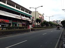
Boni Avenue
 Boni Avenue looking east towards EDSA from Maysilo Circle | |
| Length | 3.1 km (1.9 mi) |
|---|---|
| Location | Mandaluyong |
| West end | Aglipay Street in Población |
| Major junctions | Primo Cruz Street F. Martinez Avenue–San Francisco Street Barangka Drive |
| East end | Epifanio de los Santos Avenue in Barangka Ilaya |
Boni Avenue is a major east-west thoroughfare in Mandaluyong, eastern Metro Manila, Philippines. It is a six-lane divided avenue that runs from Aglipay Street (to the west) to Epifanio de los Santos Avenue (EDSA) in Barangka Ilaya (to the east). After crossing EDSA via the EDSA-Boni tunnel, the road continues under the name Pioneer Street towards Pasig. The avenue is named after the nickname of Bonifacio Javier, a decorated guerrilla leader during World War II and the mayor of Mandaluyong when the road was constructed.[1]
Route description

The avenue commences at the junction with Aglipay Street in the city's downtown area (poblacíon) where San Felipe Neri Church is located. It heads southeasterly traversing the barangays of Old and New Zañiga and San José, and crossing Primo Cruz Street before coming to a large roundabout called Maysilo Circle in Plainview. At this roundabout which houses the Mandaluyong City Hall complex and the Archdiocesan Shrine of the Divine Mercy, Boni intersects with F. Martinez Avenue and San Francisco Street. It curves northeast past Maysilo Circle as it approaches a commercial district at Barangka Drive. East of Barangka, the avenue becomes more commercial with several retail outlets and condominium developments lining this section of Boni where the Rizal Technological University is also situated. The avenue ends at the junction with EDSA where the Boni Station of the Manila MRT-3 is also located.
Landmarks

- Archdiocesan Shrine of the Divine Mercy
- Club Mwah
- Dansalan Gardens
- Mandaluyong City Hall
- Mandaluyong City Medical Center
- Maysilo Circle
- New Horizon Hotel Manila
- Rizal Technological University
- Robinsons Cybergate
- San Felipe Neri Catholic Cemetery
- San Felipe Neri Church
- San Felipe Neri Parochial School
- San Francisco Gardens
References
- ^ Some Mandaluyong residents disown ex-mayor Abalos[permanent dead link] published by Philippine Daily Inquirer; accessed 2013-10-31.
