Brayton, North Yorkshire
| Brayton | |
|---|---|
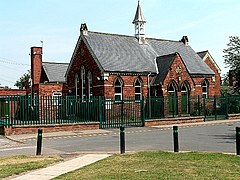
 Brayton Church of England Infant School | |
| Population | 5,299 |
| OS grid reference | SE600305 |
| • London | 160 mi (260 km) S |
| Civil parish |
|
| District | |
| Shire county | |
| Region | |
| Country | England |
| Sovereign state | United Kingdom |
| Post town | SELBY |
| Postcode district | YO8 |
| Police | North Yorkshire |
| Fire | North Yorkshire |
| Ambulance | Yorkshire |
Brayton is a small village and civil parish in the Selby district of North Yorkshire, England. The village is situated approximately 1 mile (1.6 km) south from Selby.
The United Kingdom Census 2001 states the population of Brayton to be 5,514, reducing to 5,299 at the 2011 Census.[1]
Brayton is almost entirely residential with the exception of a few local shops, including a butchers and a post office.
Village schools are Brayton High School, Brayton Juniors, and Brayton C of E Infants. The Infant School is one of the oldest buildings in the village. The school house was once home to the headmistress of Brayton school, and lessons were taken in a smaller building. The house is now a private residence, and the old school room is now a small part of the extended building.[citation needed]
Wesley Chapel and St Wilfrid's church are the two religious buildings. Wesley Chapel was founded by Charles Wesley, father of composer Samuel Wesley.[citation needed] It is now a nursery school and still a place of worship. The Grade I listed Church of England parish church, dedicated to St Wilfrid, dates from the 12th to the 15th centuries with 19th-century alterations and stained glass. Within the church is a tomb to Lord D'Arcy (died 1558), and his wife, it's effigies damaged during the 17th-century Interregnum.[2]
Governance
An electoral ward in the same name exists. This ward stretches to Barlow with a total population of 6,052.[3]
References
- ^ "Parish population 2011". Neighbourhood Statistics. Office for National Statistics. Retrieved 14 August 2015.
- ^ Historic England. "Church of St Wilfred (1132537)". National Heritage List for England. Retrieved 18 March 2015.
- ^ "Key Figures for 2011 Census: Key Statistics – Area: Brayton (Ward)". Neighbourhood Statistics. Office for National Statistics. Retrieved 27 September 2016.
External links
 Media related to Brayton, North Yorkshire at Wikimedia Commons
- Brayton College
- Brayton Community Centre
- St Wilfrid's Parish, Brayton
