Fangcun District
| Fangcun 芳村区 | |||||||
|---|---|---|---|---|---|---|---|
| District of China | |||||||
| 1949–2005 | |||||||
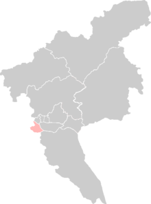
 Location of Fangcun on Guangzhou. | |||||||
| History | |||||||
• Established | 1949 | ||||||
• Disestablished | 2005 | ||||||
| |||||||
| Today part of | Part of the Liwan District | ||||||
Fangcun District (Chinese: 芳村区) was a former district in Guangzhou, Guangdong, China. It lay to the southwest of Guangzhou's modern downtown area and south of the Pearl River.[1] It was established in 1949 after the Chinese Communist Party took over Guangzhou from the Kuomintang.[2] In 2005, it merged with the Liwan District.[3][4]
since 1949, there were western Han dynasty tombs and eastern Han dynasty tombs unearthed in fsngcun district, these archaeological findings indicate us at least two thousand years ago, there were villages appeared in fangcun district.


