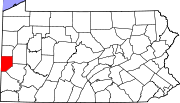
Frisco, Pennsylvania
Frisco, Pennsylvania | |
|---|---|
| Coordinates: 40°50′52″N 80°16′04″W / 40.84778°N 80.26778°W | |
| Country | United States |
| State | Pennsylvania |
| County | Beaver County |
| Elevation | 930 ft (280 m) |
| Time zone | UTC-6 (Central (EST)) |
| • Summer (DST) | UTC-4 (EST) |
| Area code | 724 |
| GNIS feature ID | 1175275[1] |
Frisco is an unincorporated community in Franklin Township, Beaver County, Pennsylvania, United States. It is located along Pennsylvania Route 288, southeast of Ellwood City. The area was the site of a tube mill during World War I.
Further reading
- Frisco Hard To Describe. Milestones, Vol. 14, No. 1. Beaver County Historical Society. 1989.
References
- ^ "US Board on Geographic Names". United States Geological Survey. 2014-03-04. Retrieved 2014-03-04.
External links


