
Hennessy Road
 Hennessy Road in Causeway Bay, junction with Yee Wo Street | |
| Native name | 軒尼詩道 Error {{native name checker}}: parameter value is malformed (help) |
|---|---|
| Namesake | John Pope Hennessy |
| Location | Hong Kong |
| Hennessy Road | |||||||||
|---|---|---|---|---|---|---|---|---|---|
| Traditional Chinese | 軒尼詩道 | ||||||||
| |||||||||
Template:Contains Chinese text

Hennessy Road (Chinese: 軒尼詩道) is a thoroughfare on Hong Kong Island, Hong Kong. It connects Yee Wo Street on the east in Causeway Bay, and Queensway on the western end in Wan Chai.
It is a two-way road with 2 to 3 lanes of traffic on each side,Trams travel along parts of the road.The road was built in the 20th century and is 1.86 kilometres long in length.
The road is named after John Pope Hennessy, the Governor of Hong Kong between 1877 and 1882.
Landmarks
- Sogo Hong Kong - department store at 555 Hennessy Road, since 1985[1]
- Hysan Place - shopping mall and office building at 500 Hennessy Road. It is developed by Hysan Development Company Limited at the former site of Hennessy Centre and due for completion in August 2012.[2]
In popular culture
The 2009 film Crossing Hennessy takes place around Hennessy Road.
Gallery
-
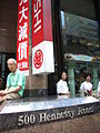 Mitsukoshi, former tennet of Hennessy Centre, closed in 2006

See also
References
- ^ "Sogo department store" Sogo Hong Kong. Retrieved 2012-03-09
- ^ Ha, Karen, "Hysan rides wave of high office, shop rents"The Standard. 9 March 2012. Retrieved 2012-03-09
External links
Wikimedia Commons has media related to Hennessy Road.
22°16′44″N 114°10′49″E / 22.27891°N 114.18019°E
This Hong Kong road article is a stub. You can help Wikipedia by expanding it. |