
Kelbrook and Sough
| Kelbrook and Sough | |
|---|---|
 Kelbrook countryside | |
 Kelbrook and Sough Location in Pendle Borough  Kelbrook and Sough Location within Lancashire | |
| Population | 1,008 (2011) |
| OS grid reference | SD9044 |
| Civil parish |
|
| District | |
| Shire county | |
| Region | |
| Country | England |
| Sovereign state | United Kingdom |
| Post town | BARNOLDSWICK |
| Postcode district | BB18 |
| Dialling code | 01282 |
| Police | Lancashire |
| Fire | Lancashire |
| Ambulance | North West |
| UK Parliament | |
Kelbrook and Sough is a civil parish in the Pendle district of Lancashire, England. It has a population of 1,008,[1] and contains the village of Kelbrook and neighbouring hamlet of Sough.
The parish adjoins the Pendle parishes of Laneshaw Bridge, Foulridge, Salterforth and Earby and West Yorkshire.
Prior to 1974 the area was part of the West Riding of Yorkshire.
According to the United Kingdom Census 2011, the parish has a population of 1,008,[1] a decrease from 1,026 in the 2001 census.[2]
Media gallery
-
 Sunset over Kelbrook
 -
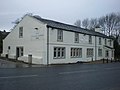 The Craven Heifer, Kelbrook
 -
 Kelbrook Beck
 -
 St Mary's Church, Kelbrook
 -
 Trig point on Kelbrook Moor


See also
Listed buildings in Kelbrook and Sough
References
Citations
- ^ a b UK Census (2011). "Local Area Report – Kelbrook and Sough Parish (1170215080)". Nomis. Office for National Statistics. Retrieved 23 February 2018.}
- ^ Office for National Statistics : Census 2001 : Parish Headcounts : Pendle Retrieved 2009-09-18
External links
![]() Media related to Kelbrook and Sough at Wikimedia Commons
Media related to Kelbrook and Sough at Wikimedia Commons
This Lancashire location article is a stub. You can help Wikipedia by expanding it. |