Khairpur District
This article needs additional citations for verification. (March 2018) |
Khairpur District | |
|---|---|
 | |
| Coordinates: 27°32′N 68°46′E / 27.533°N 68.767°E | |
| Country | |
| Province | Sindh |
| Division | Sukkur |
| Established | 1546 |
| District headquarters | Khairpur City |
| Area | |
| • Total | 15,910 km2 (6,140 sq mi) |
| Elevation | 61 m (200 ft) |
| Population (2017)[1] | |
| • Total | 2,404,334 |
| • Rank | 5th:Sindh |
| • Density | 150/km2 (390/sq mi) |
| Demonym | Khairpuri |
| Time zone | UTC+5 (PST) |
| Number of Tehsils | 8 |
| Number of Union Councils | 89 |
| Website | khairpur |
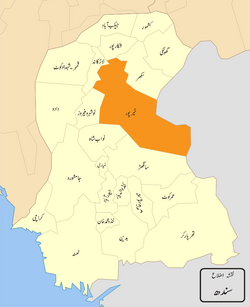
Khairpur District is a district in the Pakistani province of Sindh in Sukkur Division.[2] At the 2017 census, it was the fifth most populated district in the province after four districts of Karachi city, with 2.4 million inhabitants. The headquarters of the district is the city of Khairpur. The district is further divided into eight sub-districts:Khairpur Taluka, Mirwah Taluka, Kot Diji Taluka, Kingri Taluka, Sobho Dero Taluka, Gambat Taluka, Faiz Ganj Taluka and Nara Taluka.[3]
Location
Khairpur district is located between middle and northern Sindh. It is bounded on the north by Shikarpur District and Sukkur District, on the east by India, on the south by Sanghar District and Nawabshah District, and on the west by Larkana District, Naushahro Feroze District and Indus River. The revised area of the district is 15,910 km².
Demographics
According to the 2017 Census of Pakistan, the district had a population of 2.4 million, of which 32.3% was urban. Following are the demographic indicators of the district:
- Religion:
- Islam: 96.86%
- Hinduism: 2.93%
- Christianity: 0.09%
- Ahmaddiya: 0.07%
- Others: 0.04%
People from Khairpur District
- Pir Pagaro - President of Pakistan Muslim League (F)
- Sachal Sarmast - eighteenth-Century Sufi Poet
- Qaim Ali Shah - former Chief Minister of Sindh Province
- Ghous Ali Shah - former Defense Minister of Pakistan and Former Chief Minister of Sindh province
- Mir Ali Murad Talpur - former ruler of the princely state of Khairpur
- Naik Muhammad Panhyar - VP-Sukkur Devision Pakistan Tahreek-E-insaf
References
- ^ "DISTRICT WISE CENSUS RESULTS CENSUS 2017" (PDF). www.pbscensus.gov.pk. Archived from the original (PDF) on 29 August 2017. Retrieved 6 November 2017.
{{cite web}}: Unknown parameter|dead-url=ignored (|url-status=suggested) (help) - ^ "Khairpur: then and now - Daily Times". Daily Times. 6 February 2018. Retrieved 16 May 2018.
- ^ "Khairpur History". Khairpur.gos.pk.
Sources
- Basti, Malik Peeran Ditta daisi. "populated places of Alipur Tehsil". Local. ciclone. Retrieved 24 November 2011.[permanent dead link]
- 1998 District census report of Khairpur. Census publication. Vol. 86. Islamabad: Population Census Organization, Statistics Division, Government of Pakistan. 2000.

