
Manhattan Bridge
Manhattan Bridge | |
|---|---|
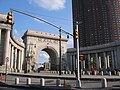
 View from Brooklyn | |
| Coordinates | 40°42′26″N 73°59′27″W / 40.7072°N 73.9908°W |
| Carries | 7 lanes of roadway, 4 tracks of the B, D, N, and Q trains of the New York City Subway, pedestrians, and bicycles |
| Crosses | East River |
| Locale | Manhattan and Brooklyn, New York City |
| Maintained by | New York City Department of Transportation |
| Characteristics | |
| Design | Suspension bridge |
| Total length | 2,089.40 meters (6,855 ft) |
| Longest span | 448.06 meters (1,470 ft) |
| History | |
| Opened | December 31, 1909 |
| Statistics | |
| Daily traffic | 80,000 |
| Location | |
 | |
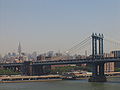
The Manhattan Bridge is a suspension bridge that crosses the East River in New York City, connecting Lower Manhattan (at Canal Street) with Brooklyn (at Flatbush Avenue Extension). It was the last of the three suspension bridges built across the lower East River, following the Brooklyn and the Williamsburg bridges. The bridge was opened to traffic on December 31, 1909 and was designed and built by Polish bridge engineer Ralph Modjeski with the deflection cables designed by Leon Moisseiff, who later designed the infamous Tacoma Narrows Bridge in 1940. It has four vehicle lanes on the upper level (split between two roadways). There are three vehicle lanes, four subway tracks, a walkway and a bikeway on the lower level. The upper level, originally used for streetcars, has two lanes in each direction, and the lower level can be one-way in peak direction or have two lanes in one direction and the other in the opposite direction. It once carried New York State Route 27 and later was planned to carry Interstate 478. No tolls are charged for motor vehicles to use Manhattan Bridge.
The original pedestrian walkway on the south side of the bridge was reopened after sixty years in June 2001. It was also used by bicycles until late summer 2004, when a dedicated bicycle path was opened on the north side of the bridge, and again in 2007 while the bike lane was used for truck access during repairs to the lower motor roadway.
- Main span 1,470 ft (448 m)
- Length of suspension cables 3224 ft (983 m)
- Total length 6,855 ft (2,089 m)
The bridge and I-478

As part of the construction of the Lower Manhattan Expressway, there were plans to make the Manhattan Bridge Interstate 478 but since this interstate would have led to a crosstown expressway and the existing Brooklyn-Queens Expressway, the FHWA said that the first digit should be even so I-478 was chosen.[1] However, with the cancellation of I-78 through New York City, the spur was dubbed useless.
Manhattan Bridge in film

- The Bridge is featured prominently in director Sergio Leone's gangster epic Once Upon a Time in America.
- In The Cowboy Way, the two main cowboy characters chase a B train over the bridge to rescue a friend in grave danger.
- The alien spacecraft that destroys New York in Independence Day makes its entrance over the Manhattan Bridge.
- The bridge is featured prominently in director Peter Jackson's 2005 remake of King Kong. In the 1930s period a very steep, simple ramp was used by automobiles to access the Bridge in contrast to today's integrated gradual ramp system into the surrounding roadways.
- The bridge was featured in an action traffic scene in the 1973 James Bond film Live and Let Die along the East River Drive when James Bond's CIA driver is assassinated by the villain Whisper in a pimpmobile and Bond has to steer the car through dangerous New York traffic.
- The bridge played a large role in the 1984 Steve Martin romantic comedy film The Lonely Guy, in which it is a popular spot for Lonely Guys to commit suicide, and the meeting place for Steve Martin and Judith Ivey.
- The bridge can be seen several times in Armageddon (1998 film) before a meteor shower destroys the city.
- In Aftershock: Earthquake in New York, a WCBS-TV helicopter flies above the East River after an earthquake strikes New York City. Both the Brooklyn and Manhattan Bridges are destroyed.
- The 2007 film I Am Legend shows the Brooklyn and Manhattan Bridges with their center spans destroyed. A flashback reveals they were hit by missiles to stop the exodus from a quarantined Manhattan.
- The bridge is seen in the background of the movie Cloverfield as the monster attacks and destroys the Brooklyn Bridge.
Subway Tracks

The four subway tracks on the bridge are used by the New York City Subway. On the Manhattan side, the south side tracks, used by N and Q trains, connect to Canal Street on the BMT Broadway Line while the north side tracks, used by the B and D trains, connect to the Chrystie Street Connection through Grand Street. On the Brooklyn side, the two pairs merge under Flatbush Avenue to a large junction with the BMT Fourth Avenue Line and BMT Brighton Line at DeKalb Avenue. For 18 years, between 1986 and 2004, one set of tracks was closed to repair structural damage.
History
When the bridge first opened, the tracks didn't connect to any others. In 1912, the Manhattan Bridge Three Cent Line and Brooklyn and North River Railroad, two streetcar companies, began operations on those tracks until the BRT (later BMT, which also had two tracks each over the Brooklyn and Williamsburg Bridges) trackage was connected to the bridge in 1915, and the trolleys were moved to the upper level roadways until 1929, when service was discontinued.[2]
The Brooklyn side of the tracks has not changed since subway service began on the bridge. It has always been fed by the four-track connection from the BMT Fourth Avenue Line. The Manhattan side has changed, however. When originally built, the two north tracks connected to the BMT Broadway Line (where the south tracks now connect), and the two south tracks curved south to join Chambers Street on the BMT Nassau Street Line along tracks now used for storage (and no longer connects to the bridge).
On November 26, 1931, a connection south of Chambers Street to the Montague Street Tunnel opened, adding two stations (Broad and Fulton Streets) and rerouted train service on the bridge's south side. Service on that side became relatively low afterwards as the only trains that normally crossed it where The Bankers' Special, which ran from either the Sea Beach and/or Fourth Avenue Line, crossed the Manhattan Bridge or Montague Street Tunnel into Manhattan, and then returned to Brooklyn via the opposite crossing.
Concurrent with the building of the Chrystie Street Connection (opened November 26, 1967) to connect to the north tracks, the south tracks were rerouted to the BMT Broadway Line connection, and the connecting tracks to the BMT Nassau Street Line were closed and subsequently removed. The connection opened two new stations (Grand Street and 57th Street-6th Avenue) and added express service on the IND Sixth Avenue Line. It also allowed the IND B and D trains to enter the BMT West End and Brighton Lines in southern Brooklyn, respectively. N (BMT Sea Beach Line) and Q (BMT Brighton Line) trains now use the south side of the bridge for service to Broadway.
Due to the tracks being on the outside of the bridge, passing trains caused the bridge to tilt and sway. This worsened as trains grew longer and heavier. Compounded with a lack of maintenance by the New York City Department of Transportation, this led to the need to close the tracks for repairs, causing major disruptions on lines that cross the span and reducing the number of trains between Manhattan and Brooklyn. The north tracks, which had been more heavily used, were closed first, from 1986 to 1988. This split the B and D trains into two sections and rerouted the N via the Montague Street Tunnel. The south tracks were closed in 1988, and except for a brief period in 1990, remained closed to trains until July 22, 2001, rerouting the Q to 6th Avenue. When the south side reopened, the north side was closed again, returning the Q to Broadway and introducing the new W line, which ran on the West End Line. On February 22, 2004, the north side reopened and all four tracks were in service simultaneously for the first time in 18 years. B and D trains returned to Brooklyn on opposite routes (B to the Brighton Line, and D to the West End Line), the N once again uses the bridge for travel, and the W no longer runs in Brooklyn. Also, the north tracks were closed during off-peak hours in 1995, and the same for the south tracks in 2003.
Gallery
-
 Cross section of the bridge
 -
 Manhattan Bridge arch on the Manhattan side
 -
 View from the Brooklyn Bridge
 -
as seen from FDR Drive


References
- ^ 3 digit interstates x78, accessed December 19, 2006
- ^ BMT 4th Avenue Subway, accessed December 19, 2006
External links
- Bridges at New York City DOT
- NYCroads.com - Manhattan Bridge
- NYCsubway.org - Manhattan Bridge FAQ Sheet
- Transportation Alternatives Fiboro Bridges - Manhattan Bridge
- NYCfoto.com - Photos of Manhattan Bridge
- [1] - Manhattan Bridge by Flavio Germano
- Manhattan Bridge at Structurae
- Template:Geolinks-US-streetscale