Mount Coolum National Park
| Mount Coolum National Park Queensland | |
|---|---|
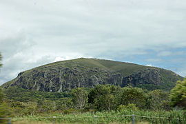
 Mount Coolum seen from the southeast | |
| Coordinates | 26°33′48″S 153°05′02″E / 26.56333°S 153.08389°E |
| Established | 1990 |
| Area | 0.69 km2 (0.27 sq mi) |
| Managing authorities | Queensland Parks and Wildlife Service |
| Website | Mount Coolum National Park |
| See also | Protected areas of Queensland |
Mount Coolum is a hill in Mount Coolum National Park in a suburb of the same name in Queensland, Australia.[1][2] Mount Coolum is located on the Sunshine Coast, 101 km north of Brisbane. It lies between the Sunshine Motorway to the west, the shoreline to the east, Coolum Beach township to the north and Marcoola township to the south.
Formation
[edit]Created about 26 million years ago, Mount Coolum is a laccolith, formed when a dome-shaped bulge of magma cooled below the Earth's surface,[3] roughly circular in plan with tall cliffs on the eastern and southern side. It rises abruptly from the coastal plain to a 208 m peak, resembling the Glasshouse Mountains to the south. Mount Coolum is largely formed from 26 million year old rhyolite which forms regular columns and jointing patterns. A disused quarry occupies the eastern foothills of the mountain. After heavy rain there are a number of waterfalls on the cliffs.[citation needed]
Climbing Mount Coolum
[edit]A 1.6 km[4] long track climbs Mount Coolum from the east, starting at a carpark on Tanah Street West off David Low Way in the suburb of Mount Coolum. The lower part of the track is deceptively well-formed and gentle but it quickly deteriorates to become very steep, very rough and dangerously slippery when wet.[5]
The walk up and back can be completed in 30–40 minutes; it should not be started after rain or when rain, storms or dusk threaten. The peak hosts a cage containing an aircraft hazard obstacle light, necessary because of the mountain's close proximity to the Sunshine Coast Airport. On average about 140 people climb to the summit each day.[6]
Ecological values
[edit]The park is noted for its remarkable botanical diversity; more than 700 different species of plant have been identified there. Vegetation types include eucalypt forest, coastal wallum, paperbark wetland, rare coastal montane heath and some rainforest.[citation needed]
A pair of peregrine falcons are reported to nest on the cliffs.[citation needed]
See also
[edit]References
[edit]- ^ "Mount Coolum – hill in the Sunshine Coast Region (entry 8153)". Queensland Place Names. Queensland Government. Retrieved 24 July 2021.
- ^ "Mount Coolum National Park – national park in the Sunshine Coast Region (entry 51318)". Queensland Place Names. Queensland Government. Retrieved 24 July 2021.
- ^ QLD NationalParks and Wildlife http://www.nprsr.qld.gov.au/parks/mount-coolum/about.html Archived 12 November 2014 at the Wayback Machine
- ^ (Signage at trail start)
- ^ "Mount Coolum National Park". Department of National Parks, Sport and Racing. Archived from the original on 5 February 2018. Retrieved 4 February 2018.
- ^ Kathy Sundstrom (9 March 2011). "Call to restrict climbing on popular Sunshine Coast mountain". Brisbane Times. Fairfax Media. Archived from the original on 10 March 2011. Retrieved 14 March 2011.

