
Old Hunstanton Lighthouse
 Old Hunstanton Lighthouse | |
 | |
| Location | St Edmund’s Point Norfolk England |
|---|---|
| OS grid | TF6763042048 |
| Coordinates | 52°56′59″N 0°29′38″E / 52.949645°N 0.493760°E |
| Tower | |
| Constructed | 1272 (first) 1778 (second) |
| Construction | masonry tower |
| Height | 19 metres (62 ft) |
| Shape | cylindrical tower with balcony attached to 2-storey keeper's house |
| Markings | white tower |
| Operator | The Old Lighthouse[1] |
| Heritage | Grade II listed building |
| Light | |
| First lit | 1840 (current) |
| Deactivated | 1922 |
Listed Building – Grade II | |
| Designated | 20 September 1984 |
| Reference no. | 490402[2] |
Old Hunstanton Lighthouse is located in Old Hunstanton in the English county of Norfolk.[3] The present lighthouse was built in 1840 although there has been a Lighthouse on the site since 1665. This first lighthouse was built of wood with an iron basket of burning coals as a light. Hunstanton lighthouse had the world's first parabolic reflector which was built here in 1776. The present lighthouse ceased operations in 1922, since when it has been a private residence and a Holiday Let.
Gallery
-
 Remains of St Edmund's Chapel and Lighthouse.
 -
 Close-up view
 -
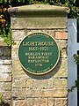 Plaque outside the lighthouse
 -
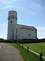 Another view
 -
 Trinity House coat of arms on the tower
 -
 The lighthouse at dusk
Jul1992.jpg)


See also
References
- ^ Hunstanton The Lighthouse Directory. University of North Carolina at Chapel Hill. Retrieved 28 April 2016
- ^ Listed Building schedule
- ^ Ordnance Survey (2002). OS Explorer Map 250 - Norfolk Coast West. ISBN 0-319-21886-4.
External links
Wikimedia Commons has media related to Old Hunstanton Lighthouse.
This article about a Norfolk building or structure is a stub. You can help Wikipedia by expanding it. |