
Perry Township, Monroe County, Indiana
Perry Township | |
|---|---|
 Location in Monroe County | |
| Country | |
| State | |
| County | Monroe |
| Government | |
| • Type | Indiana township |
| Area | |
• Total | 35.48 sq mi (91.9 km2) |
| • Land | 35.36 sq mi (91.6 km2) |
| • Water | 0.12 sq mi (0.3 km2) 0.34% |
| Elevation | 741 ft (226 m) |
| Population (2010) | |
• Total | 50,673 |
| • Density | 1,433.2/sq mi (553.4/km2) |
| ZIP codes | 47401, 47403, 47404 |
| GNIS feature ID | 0453723 |
Perry Township is one of eleven townships in Monroe County, Indiana, United States. As of the 2010 census, its population was 50,673 and it contained 24,194 housing units.[1]
History
Perry Township was established in 1830.[2] It was named for Commodore Matthew C. Perry.[3]
Geography
According to the 2010 census, the township has a total area of 35.48 square miles (91.9 km2), of which 35.36 square miles (91.6 km2) (or 99.66%) is land and 0.12 square miles (0.31 km2) (or 0.34%) is water.[1]
Cities, towns, villages
- Bloomington (southern half of the city, south of [approximately] Third Street)
Unincorporated towns
- Broadview at 39°08′23″N 86°32′18″W / 39.13977°N 86.538330°W
- Clear Creek at 39°06′33″N 86°32′24″W / 39.109214°N 86.539997°W
- Handy at 39°05′45″N 86°29′38″W / 39.095881°N 86.493884°W
- Hoosier Acres at 39°09′28″N 86°29′13″W / 39.157825°N 86.48694°W
- Ridgemede at 39°09′07″N 86°30′11″W / 39.151992°N 86.503052°W
- Sanders at 39°04′47″N 86°30′48″W / 39.079770°N 86.513329°W
- Sunny Slopes at 39°07′55″N 86°31′52″W / 39.131992°N 86.531108°W
(This list is based on USGS data and may include former settlements.)
Cemeteries
The township contains Mount Salem Cemetery.
Major highways
School districts

- Monroe County Community School Corporation
Political districts
- Indiana's 9th congressional district
- State House District 60
- State House District 61
- State Senate District 40
Gallery
-
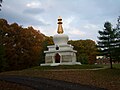 Kalacakra Stupa, Tibetan Mongolian Buddhist Cultural Center
 -
 All Saints' Orthodox Church on a winter day
 -
 A county road crossing Clear Creek
 -
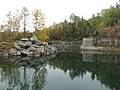 An old limestone quarry


References
- "Perry Township, Monroe County, Indiana". Geographic Names Information System. United States Geological Survey, United States Department of the Interior. Retrieved 2009-09-27.
- United States Census Bureau 2008 TIGER/Line Shapefiles
- IndianaMap
- ^ a b "Population, Housing Units, Area, and Density: 2010 - County -- County Subdivision and Place -- 2010 Census Summary File 1". United States Census. Retrieved 2013-05-10.
- ^ Blanchard, Charles (1884). Counties of Morgan, Monroe and Brown, Indiana: Historical and Biographical. F.A. Battey & Company. p. 381.
- ^ History of Lawrence and Monroe Counties, Indiana: Their People, Industries, and Institutions. B.F. Bowen. 1914. p. 417.
External links
- Indiana Township Association
- United Township Association of Indiana
- City-Data.com page for Perry Township
Places adjacent to Perry Township, Monroe County, Indiana | |
|---|---|
Municipalities and communities of Monroe County, Indiana, United States | ||
|---|---|---|
| City |  | |
| Towns | ||
| Townships | ||
| CDPs | ||
| Other communities | ||