Rhin-et-Moselle
| Rhin-et-Moselle Rhin-et-Moselle | |||||||||||||
|---|---|---|---|---|---|---|---|---|---|---|---|---|---|
| Department of First French Empire | |||||||||||||
| 1798–1814 | |||||||||||||
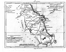
 Map of the Rhin-et-Moselle department | |||||||||||||
| Capital | Koblenz | ||||||||||||
| Area | |||||||||||||
• 1812 [1] | 5,884.19 km2 (2,271.90 sq mi) | ||||||||||||
| Population | |||||||||||||
• 1812 [1] | 269,700 | ||||||||||||
| History | |||||||||||||
• Established | 1798 | ||||||||||||
• Disestablished | 1814 | ||||||||||||
| Political subdivisions | Koblenz Bonn Simmern | ||||||||||||
| |||||||||||||
| Today part of | North Rhine-Westphalia Rhineland-Palatinate | ||||||||||||
Rhin-et-Moselle ([ʁɛn.e.mɔzɛl]; German: Rhein-und-Mosel) was a department of the First French Empire in present-day Germany. It was named after the rivers Rhine and Moselle. It was formed in 1798, when the left bank of the Rhine was annexed by France. Until the French occupation, its territory was divided between the Archbishopric of Cologne, the Archbishopric of Trier, and the Electorate of the Palatinate. Its territory is now part of the German states of Rhineland-Palatinate and North Rhine-Westphalia. Its capital was Koblenz.
The department was subdivided into the following arrondissements and cantons (situation in 1812):[1]
- Koblenz, cantons: Koblenz, Andernach, Boppard, Cochem, Kaisersesch, Lutzerath, Mayen, Münstermaifeld, Polch, Rübenach, Treis and Zell.
- Bonn, cantons: Bonn (2 cantons), Adenau, Ahrweiler, Remagen, Rheinbach, Ulmen, Virneburg and Wehr.
- Simmern, cantons: Simmern, Bacharach, Kastellaun, Kirchberg, Kirn, Kreuznach, Sankt Goar, Sobernheim, Stromberg and Trarbach.
Its population in 1812 was 269,700, and its area was 588,419 hectares.[1]
After Napoleon was defeated in 1814, the department became part of Prussia.
References
- ^ a b c Almanach Impérial an bissextil MDCCCXII, p. 456-457, accessed in Gallica 26 July 2013 Template:Fr icon
