Ringsted Municipality
Appearance
Ringsted Municipality
Ringsted Kommune | |
|---|---|
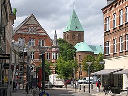
 A street in Ringsted | |
 | |
| Country | Denmark |
| Region | Region Zealand |
| Seat | Ringsted |
| Government | |
| • Mayor | Henrik Hvidesten (V) |
| Area | |
| • Total | 295.48 km2 (114.09 sq mi) |
| Population (1 January 1, 2012) | |
| • Total | 33,062 |
| • Density | 110/km2 (290/sq mi) |
| Time zone | UTC+1 (CET) |
| • Summer (DST) | UTC+2 (CEST) |
| Municipal code | 329 |
| Website | www.ringsted.dk |
Ringsted Municipality is a municipality (Danish, kommune) in Region Sjælland on the island of Zealand (Sjælland) in east Denmark. The municipality covers an area of 295 km², and has a total population of 32,092 (2008). Its mayor is Niels-Ulrik Hermansen, a member of Venstre
The main town and the site of its municipal council is the city of Ringsted.
Ringsted municipality was not be merged with other municipalities by January 1, 2007 as the result of nationwide Kommunalreformen ("The Municipal Reform" of 2007).
Urban areas
The ten largest urban areas in the municipality are:
| # | Locality | Population |
|---|---|---|
| 1 | Ringsted | 21,151 |
| 2 | Jystrup | 744 |
| 3 | Ørslev | 672 |
| 4 | Kværkeby | 598 |
| 5 | Vetterslev | 562 |
| 6 | Høm | 472 |
| 7 | Vigersted | 470 |
| 8 | Sneslev | 390 |
| 9 | Farendløse | 362 |
| 10 | Gyrstinge | 348 |
Others include Ortved.
Attractions
- St. Bendt's Church (Skt. Bendts Kirke) is located in the middle of the town. The church contains several royal tombs.
- Skjoldenæsholm Tram Museum
Image gallery
-
Sneslev Church
References
- Municipal statistics: NetBorger Kommunefakta, delivered from KMD aka Kommunedata (Municipal Data)
- Municipal mergers and neighbors: Eniro new municipalities map
External links
Wikimedia Commons has media related to Ringsted Kommune.
55°27′N 11°49′E / 55.450°N 11.817°E


