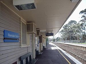
Riversdale railway station
Riversdale | |||||||||||
|---|---|---|---|---|---|---|---|---|---|---|---|
 Northbound view from Platform 1 in March 2003 | |||||||||||
| General information | |||||||||||
| Location | Wandin Road, Camberwell | ||||||||||
| Coordinates | 37°49′53″S 145°04′11″E / 37.8315°S 145.0697°E | ||||||||||
| Owned by | VicTrack | ||||||||||
| Operated by | Metro | ||||||||||
| Line(s) | Alamein | ||||||||||
| Distance | 11.73 kilometres from Southern Cross | ||||||||||
| Platforms | 2 side | ||||||||||
| Tracks | 2 | ||||||||||
| Connections | Tram | ||||||||||
| Construction | |||||||||||
| Structure type | Ground | ||||||||||
| Parking | 32 | ||||||||||
| Other information | |||||||||||
| Status | Unstaffed station | ||||||||||
| Station code | RIV | ||||||||||
| Fare zone | Myki zone 1 | ||||||||||
| Website | Public Transport Victoria | ||||||||||
| History | |||||||||||
| Opened | 30 May 1890 | ||||||||||
| Electrified | Yes | ||||||||||
| Services | |||||||||||
| |||||||||||
Riversdale railway station is located on the Alamein line in Victoria, Australia. It serves the eastern Melbourne suburb of Camberwell opening on 30 May 1890 along with the first section of the Outer Circle line, drawing its name from the adjacent Riversdale Road.[1]
Some trains also terminate at Riversdale after morning and evening peaks and return to Camberwell for stabling.
Though it was closed for a year in 1897/98 when the Outer Circle line closed, it reopened soon after, due to a public outcry.[2] The station also features unusual manually operated boom gates, with arms that are divided into two sections, so as not to collide with overhead tram wires.
Platforms & services
Riversdale has two side platforms. It is serviced by Metro Trains' Alamein line services.[3]
Platforms 1:
- Alamein line: all stations and limited stops services to Flinders Street (weekdays) and Camberwell
Platforms 2:
- Alamein line: all stations services to Alamein
Transport links
Yarra Trams operates one route via Riversdale station:
CDC Melbourne operates one route via Riversdale station:
References
- ^ Riversdale Vicsig
- ^ David Beardsell & Bruce Herbert (1979). The Outer Circle: A history of the Oakleigh to Fairfield Park Railway. Australian Railway Historical Society. p. 68. ISBN 0-85849-024-2.
- ^ Alamein Line timetable Public Transport Victoria
- ^ Route 70 Waterfront City Docklands - Wattle Park timetable Public Transport Victoria
- ^ Route 612 Box Hill - Chadstone Archived 9 May 2015 at the Wayback Machine Public Transport Victoria
External links
 Media related to Riversdale railway station, Melbourne at Wikimedia Commons
- Melway map at street-directory.com.au
| Preceding station | Disused railways | Following station | ||
|---|---|---|---|---|
| East Camberwell | style="background:#Template:Victoria color; color:inherit; border-left: 0px none; border-right: 0px none; border-top:1px #aaa solid; border-bottom:0px none;" | | Outer Circle line | style="background:#Template:Victoria color; color:inherit; border-left: 0px none; border-right: 0px none; border-top:1px #aaa solid; border-bottom:0px none;" | | Burwood |
| List of closed railway stations in Melbourne | ||||
