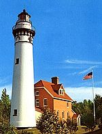
Sherwood Point Light
 | |
 | |
| Location | Idlewild, Wisconsin |
|---|---|
| Coordinates | 44°53′34″N 87°26′0.36″W / 44.89278°N 87.4334333°W[1] |
| Tower | |
| Foundation | Concrete |
| Construction | Brick |
| Automated | 1983 |
| Height | 37 feet (11 m) |
| Shape | Square[1] |
| Heritage | National Register of Historic Places listed place |
| Light | |
| First lit | 1883 |
| Focal height | 18.5 m (61 ft) |
| Lens | Fifth order Fresnel lens |
| Range | 15 nautical miles (28 km; 17 mi)[1] |
| Characteristic | White, Isophase 6 s[1] |
The Sherwood Point lighthouse is a lighthouse located near Idlewild in Door County, Wisconsin, United States.
Situated on the west side of the north entrance to Sturgeon Bay, it was listed in the National Register of Historic Places in 1984, as the Sherwood Point Light Station, reference #84003663.
Further reading
- Havighurst, Walter. The Long Ships Passing: The Story of the Great Lakes. Macmillan, 1943.
- Oleszewski, Wes, Great Lakes Lighthouses, American and Canadian: A Comprehensive Directory/Guide to Great Lakes Lighthouses. Gwinn, MI: Avery Color Studios, 1998. ISBN 0-932212-98-0.
- Sapulski, Wayne S. Lighthouses of Lake Michigan: Past and Present. Fowlerville, MI: Wilderness Adventure Books, 2001. ISBN 0-923568-47-6.
- Wright, Larry and Patricia, Great Lakes Lighthouses Encyclopedia. Erin: Boston Mills Press, 2006. ISBN 1-55046-399-3.
Gallery
References
- ^ a b c d Light List, Volume VII, Great Lakes (PDF). Light List. United States Coast Guard. 2014.
- "Historic Light Station Information and Photography: Wisconsin". United States Coast Guard Historian's Office. Archived from the original on 2017-05-01.
- Light List, Volume VII, Great Lakes (PDF). Light List. United States Coast Guard.
External links
Wikimedia Commons has media related to Sherwood Point Light Station.
- Sherwood Point Lighthouse, Door County Maritime Museum
- Pepper, Terry, Seeing the light, Sherwood Point Light Station
- Lighthouse friends article
- NPS Inventory of Historic Light Stations - Wisconsin
- Pepper, Terry. "Seeing the Light: Lighthouses on the western Great Lakes".


