Slatedale, Pennsylvania
Slatedale, Pennsylvania | |
|---|---|
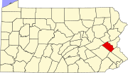
 Location of Slatedale in Lehigh County, Pennsylvania | |
Location of Slatedale in Pennsylvania | |
| Coordinates: 40°44′40″N 75°39′24″W / 40.74444°N 75.65667°W | |
| Country | |
| State | |
| County | Lehigh |
| Township | Washington |
| Area | |
| • Census-designated place | 0.77 km2 (0.30 sq mi) |
| • Land | 0.77 km2 (0.30 sq mi) |
| • Water | 0.0 km2 (0.0 sq mi) |
| Elevation | 153 m (501 ft) |
| Population | |
| • Census-designated place | 455 |
| • Density | 590.0/km2 (1,528/sq mi) |
| • Metro | 865,310 (US: 68th) |
| Time zone | UTC-5 (Eastern (EST)) |
| • Summer (DST) | UTC-4 (EDT) |
| ZIP Codes | 18079, 18080 |
| Area code(s) | 610 and 484 |
| FIPS code | 42-71080 |
| GNIS feature ID | 1187788 |
Slatedale is an unincorporated community and census-designated place (CDP) in Washington Township in Lehigh County, Pennsylvania. As of the 2010 census, it had a population of 455.[2] It is part of the Lehigh Valley, which had a population of 861,899 and was the 68th-most populous metropolitan area in the U.S. as of the 2020 census.
Geography
[edit]Slatedale is in northern Lehigh County, west of the center of Washington Township. It is 3 miles (5 km) west of the borough of Slatington and 16 miles (26 km) northwest of Allentown, the county seat and the third most populous city in Pennsylvania. Both Slatedale and Slatington are named after the large amount of slate found in the area.
According to the U.S. Census Bureau, Slatedale has a total area of 0.3 square miles (0.8 km2), of which 0.6 acres (2,464 m2), or 0.32%, are water.[1] Trout Creek forms the southern border of the community and flows east to the Lehigh River in Slatington. Blue Mountain rises 2 miles (3 km) to the north.
Services
[edit]Slatedale is served by the Citizen's Fire Co #1 in Slatedale for fire protection and Northern Valley EMS for ambulance services. While it has its own box post office with the ZIP Code of 18079, surrounding areas use the Slatington ZIP Code of 18080.
| Census | Pop. | Note | %± |
|---|---|---|---|
| 2000 | 389 | — | |
| 2010 | 455 | 17.0% |
References
[edit]- ^ a b "2019 U.S. Gazetteer Files: Places: Pennsylvania". United States Census Bureau. Retrieved October 28, 2020.
- ^ a b "Total Population: 2010 Census DEC Summary File 1 (P1), Slatedale CDP, Pennsylvania". data.census.gov. U.S. Census Bureau. Retrieved October 28, 2020.


