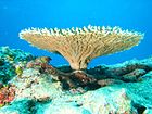
St. Crispin's Reef
St. Crispin's Reef is an elongate outer-shelf[1] coral reef in the Great Barrier Reef, Queensland, Australia.
Location and topography
[edit]Named after St. Crispin, the French patron saint of cobblers and tanners,[2] St. Crispin's Reef is located 35 miles off the Queensland coast in the Coral Sea,[3] in latitude 16° 07' 54.14" S longitude 145° 48' 22.46" E, at a depth of 9 metres.[4] It lies east of Undine Reef and south of Agincourt Reefs, close to Opal Reef.[5][6] Protected by neighbor reefs, St. Crispin's structure consists of many shallow sandy channels that reticulate around coral mounds, rather than a typical reef slope. It has an abundance of soft corals and colourful marine life.[7]
Marine life
[edit]St. Crispin's Reef is a popular diving and snorkeling spot for expeditions from Port Douglas and Cairns.[8] Nicknamed "Flower garden", the reef is host to Sergeant majors, Sweet lips, reef sharks, feather stars and bumphead parrot fish.[3][9]
Classification
[edit]Classified by the Marine Park Authority for "Intensive use",[10] the reef has four moorings.[3] In 1998, divers Tom and Eileen Lonergan were accidentally left here by their dive expedition, and went missing. Their bodies were never found. The tragedy inspired the film Open Water.[11]
References
[edit]- ^ Great Barrier Reef coral bleaching surveys 2006 (research publication no. 87). Australia: Great Barrier reef Marine Park Authority. 2006. p. 48.
- ^ "Survey 22 - St. Crispin's reef". Surveys of the Great Barrier Reef. Catlin Seaview Survey. Archived from the original on 27 May 2014. Retrieved 27 May 2014.
- ^ a b c "Snorkeling at St. Crispin's reef". Wavelength. Retrieved 27 May 2014.
- ^ "St. Crispin's Reef". Transects of St. Crispins reef. Global Reef Record. Archived from the original on 27 May 2014. Retrieved 27 May 2014.
- ^ "Location of St. Crispin's reef". Wikimapia. Archived from the original on 27 May 2014. Retrieved 27 May 2014.
- ^ "Map of great barrier reef". Dive Maps of Australia. PADI - Professional Association of Diving Instructors. Archived from the original on 27 May 2014. Retrieved 27 May 2014.
- ^ "2012 survey - St. Crispin's reef". Catlin Seaview Survey. Archived from the original on 31 July 2017. Retrieved 27 May 2014.
- ^ "Major reef sites from Port Douglas". Frommers. Archived from the original on 27 May 2014. Retrieved 27 May 2014.
- ^ Zell, len (1 May 2014). The Great Barrier Reef: A Journey Through the World's Greatest Natural Wonder. Murdoch Books. ISBN 978-1743361795.
- ^ "Classification of reefs". Great Barrier Reef Marine Park Authority. Archived from the original on 27 May 2014. Retrieved 27 May 2014.
- ^ "Mystery of couple left behind in shark-infested waters still missing 23 years on". Daily Mirror. 5 June 2021.

