
User talk:Seav/Archive 1
| This page is an archive of past discussions. Do not edit the contents of this page. If you wish to start a new discussion or revive an old one, please do so on the current talk page. |
Welcome!
Hello there Seav, welcome to the 'pedia! I hope you like the place and decide to stay. If you need pointers on how we title pages visit Wikipedia:Naming conventions or how to format them visit our manual of style. If you have any other questions about the project then check out Wikipedia:Help or add a question to the Village pump. Cheers! --maveric149
Image copyright
Created and copyright (2003) by Eugene Villar (seav).)
- Yep. :) —seav
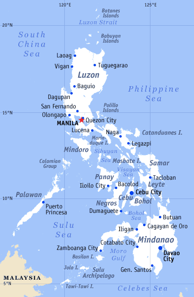
Maps of the Philippines
Hello,
I welcome your efforts in creating very useful maps of the Phillipines but please consider creating also versions without any lettering that could be reused on other than the English Wikipedias.
Kpjas 07:20 15 Jun 2003 (UTC)
- Would a gzipped archive containing all the images without any text be sufficient? That way, anyone can download it and supply the text (in Photoshop/Corel Draw/GIMP) in their own language. —seav 07:45 15 Jun 2003 (UTC)
- If it is not too large. The other thing is wheather gzip archives are acceptable for upload on Wikipedia.
Kpjas 08:09 15 Jun 2003 (UTC)
- If it is not too large. The other thing is wheather gzip archives are acceptable for upload on Wikipedia.
- The archive is a bit large, and I get a warning when I upload it. Do you need it immediately (are you by any chance doing Polish articles on the provinces)? I could probably upload it on a different server and link to it from here. At least I have them ready for when somebody needs them (which I don't think will be for quite a long while). —seav 16:10 15 Jun 2003 (UTC)
- Right. I feel that (at least on the Polish Wikipedia) no-one will write these articles for quite a while but if you would ever leave the project... We (at the WP-PL) would appreciate a map of the Phillipines with cities etc. marked but not described. We are forced to use CIA maps for countries because there are no PD Polish maps. You could send it to me and I'll upgrade the article about the Phillipines on the Polish Wikipedia. Thank you in advance.
Kpjas 17:08 15 Jun 2003 (UTC)
- Right. I feel that (at least on the Polish Wikipedia) no-one will write these articles for quite a while but if you would ever leave the project... We (at the WP-PL) would appreciate a map of the Phillipines with cities etc. marked but not described. We are forced to use CIA maps for countries because there are no PD Polish maps. You could send it to me and I'll upgrade the article about the Phillipines on the Polish Wikipedia. Thank you in advance.
- Wonderful. Thank you very much. I am certain this is really a very important contribution to the Wikipedia as an one big international project.
Kpjas 09:05 16 Jun 2003 (UTC)
- Wonderful. Thank you very much. I am certain this is really a very important contribution to the Wikipedia as an one big international project.
- You're welcome! :) —seav 09:18 16 Jun 2003 (UTC)
Hi, May I know what rpgoram you are using for making the maps? Thanks a lot!
Polish Map of the Philippines
Seav,
You might want to take a look at the translated map on the Polish Wikipedia.
article about the Philippines.
Kpjas 16:02 17 Jun 2003 (UTC)
- It looks really nice. :) Glad I could help you out with a Polish version map. You might want to take a look at the list of provinces and cities. There are already 79 provinces and 116 (!) cities as of today that I know of. The list from the CIA is outdated.
- Does Polish have translation for the provinces? I know that Southern Leyte could be translated as well as Northern Samar. (For instance, in my native language, Tagalog, it's read as Timog Leyte and Hilagang Samar.) I've also seen another page on the Internet that translated the del Sur's and del Norte's into du Suds and du Nords (but I don't know what language it is).
- Anyway, could I have a translated version of pl:Benigno Aquino? I could use it to start Benigno Aquino, Jr. Thanks! :)
- —seav 21:46 17 Jun 2003 (UTC)
- Du Sud and du Nord are French translations. They are not used in English. The Spanish translations might, being a former language of the Philippines. --Menchi 12:37 18 Jun 2003 (UTC)
Standard ext-link format
You don't have to do <div style="font-size:smaller;">http://www.antique.gov.ph</div>; just type <small>http://www.antique.gov.ph</small>.
But, that is not the proper external link format either. See Wikipedia:Describe external links. However, description is not necessary for Official website. Such desc is mainly for specific and generally obscure webpages.
--Menchi 10:37 14 Jul 2003 (UTC)
- About the <small>..</small> markup, I was assuming that that element was deprecated in HTML 4.01, so I was going with style sheets, and the divs give the added benefit that it is a block-level element, not an inline element like the small element. And the reason I chose that particular formatting was because I think it's good to see the URL. (Although admittedly, anyone can see the URL by focusing on the link and looking at the statusbar.) —seav 10:55 14 Jul 2003 (UTC)
Scientific Classification
Could you drop by talk:Scientific classification? I'm trying to continue a discussion you started on the Reference Desk. -Smack 01:34 17 Jul 2003 (UTC)
Adminship nomination
By the way, you might be interested in knowing that someone nominated you to become an admin about a week ago, see Wikipedia:Requests for adminship, and reply there if you are interested. If you reply there quickly, you could be number 100! כסיף Cyp 20:49 20 Jul 2003 (UTC)
- Just copying from Wikipedia:Requests for adminship, in case you forgot about it: (כסיף Cyp)
Ninoy Aquino
I'm all for a move back to Benigno Aquino Jr. now that you've explained it. Sorry for the hassle. - Hephaestos 08:31 27 Jul 2003 (UTC)
Map for Regions
Please create maps for the regions. It would be good to create a map with the region divisions (for the regions article) and individual maps for the regions themselves. I'm not sure though if it would be better to create a map with the provinces of the region in focus (as in close-up) or with the whole Philippines in focus.
I could do it myself. But then I think that would infringe your copyright.
--wdmanuel August 18, 3:11 PM (Singapore Time)
- Ok... I've been meaning to do it anyway. :) --seav 07:16, Aug 18, 2003 (UTC)
ADB Tables
Sorry, please just return it if you want. The monitor i'm using now (not mine) has a very high resolution. Can i have your e-mail? wayne manuel 07:51, 18 Aug 2003 (UTC)
Thank you. I removed it in case. Do spambots search the history also? wayne manuel 08:10, 18 Aug 2003 (UTC)
- if it's a spambot, i'm sure it will. ok lang yun, i doubt any spambot can recognize <tuldok>. --seav 08:25, Aug 18, 2003 (UTC)
Please check the Talk:SOCCSKSARGEN page. wayne manuel 08:26, 18 Aug 2003 (UTC)
Executive Orders
Could we also create the Executive Orders page. Or should it be together with it. wayne manuel 05:47, 19 Aug 2003 (UTC)
- We could probably create such pages but I'm not sure of the numbering. Did it start from Cory? or does each president restart the numbers? What about the Presidential Decrees of Marcos? And the Commonwealth Acts during the 1930s and 1940s? I'm not sure if all should have independent pages. If they'll be lumped together into 1 page, what would be the page's title? --seav 08:23, Aug 19, 2003 (UTC)
Is the date of the Republic Acts of the Philippines creating most of the provinces really correct? --wayne manuel 08:52, 19 Aug 2003 (UTC)
- There are two dates, I think associated with new R.A.s establishing new provinces, cities, municiaplities, etc: the date the bill was signed and the date it was approved through a plebiscite. Regarding R.A. 2711, it seems that the whole title is "Revised Administrative Code of the Philippines: Act No. 2711 Approved March 10, 1917, as Amended up to August 29, 1940". Maybe they used a different numbering for that but certainly took effect on March 10, 1917. I've seen so many provincial histories citing their creation on that Act. Most cite it as a Republic Act. Another webpage called it a Commonwealth Act (which is ridiculous since the Commonwealth didn't exist then). I guess pre and post commonwealth is a good division. --seav 09:07, Aug 19, 2003 (UTC)
try searching google using this link: http://www.google.com.sg/search?hl=en&ie=UTF-8&oe=UTF-8&q=site%3A206.142.245.159+ra+province+creating
Thanks
Thanks for the edits... :) ...learned something new. Very nice maps btw. Mang Kiko 01:54, 19 Aug 2003 (UTC)
- Thanks! --seav 02:13, Aug 19, 2003 (UTC)
How can I help you put the images into the pages? Is there a format --wayne manuel 02:15, 19 Aug 2003 (UTC)
My apologies. I thought they were just names. It sure isn't clear from the articles that they're not just names like the rest of the regions. RickK 02:33, 19 Aug 2003 (UTC)
XXX
It's been over 20 years since I visited Manila. At that time the US military presence promoted Manila's reputation as a XXX city. One wouldn't want the whole country to be tarred with that image, or the Australian XXXX reputation that would be too much competition for San Miguel. :-) ☮ Eclecticology 10:00, 2003 Aug 19 (UTC)
Abu Sayyaf
You didn't need to rewrite the section on Abu Sayyaf as it was originally written by the US government and released into the public domain so wasn't copyrighted. --Imran 10:37, 20 Aug 2003 (UTC)
- Oh ok. So should it be reverted? Also, the write-up didn't cover their kidnappings of tourists from Palawan, including Martin and Gracia Burnham. --seav 16:55, Aug 20, 2003 (UTC)
- Nah, it's fine as it is. --Imran 21:02, 20 Aug 2003 (UTC)
Wikipedia:Copyright violations on history pages
Seav, I've noticed your comment on the Wikipedia:copyright issues regarding the status of page histories. I agree with you regarding the copyright infringement issues and like you I have not found any other discussion about this topic so I started a new meta page on it Wikipedia:Copyright violations on history pages. Alex756 15:49, 22 Aug 2003 (UTC)
Philippines on world map
Yeah, I know I globbed them all together; I did that with practically all the major island groupings (especially Canada), since once this map gets to 300-pixel size, they'll be indistinguishable anyway. At any rate, I'm thinking this map will be only for highlighting large territories; most countries will be highlighted on smaller, more detailed continent/region maps, which I am being more careful with :-) -- Wapcaplet 17:19, 4 Sep 2003 (UTC)
Symbols of the Philippine Flag
Hey dude! I know about RA 8491. But I just want to point out that the original shade of blue on the flag was note sky blue, navy blue, or the currently authorised royal blue. Colours aside, RA 8391 does not state the symbolism of the heraldic items. The "current symbolism" which you find in tourism books and even school textbooks is not the true symbolism of the flag. It's not even "official." The original meanings were changed in the 60's at the start of the Pesudo-Nationalist movement which was determined to get rid of American and Spanish influences which were seen as "detrimental to the national identity." They changed names, spelling, significances, etc. In short, they whitewashed history to conform to their idea of nationalism.
While it may have been honest love for the nation, it was misguided, poorly implemented, and aggravated the non-Tagalog peoples of the nation. Keep the current colour of the flag, BUT THE ORIGINAL SYMBOLISM, AS STATED IN THE 1898 PHILIPPINE DECLARATION OF INDEPENDENCE FROM SPAIN, AND AUTHORISED BY CAPTAIN-GENERAL EMILIO AGUINALDO Y FAMY, PRESIDENT OF THE REPUBLIC, SHOULD STAY.
History is not about making people look good or bad. It is simply to record events for future generations to learn how we came to be. Embracing a false past will not give the Philippines a future. Take time to read the original documents. It's interesting.
http://www.msc.edu.ph/centennial/declaration.html
Read up on Ambeth Ocampo's books and Inquirer column. History, TRUE HISTORY IS AMAZING! I love my country for it, warts and all.
Historical Philippine Flag
Okay. I put up the info you asked for and added a few more notes. Do you think you could help me make a more accurate Historical Philippine Flag for upload to this site? The one where we had a LOT more rays on the sun that we have now and had a mythical face? It'll be a good for people to compare the flag we have now and what was originally intended by the First Republic. You can email me at repdevcon@hotmail.com to tell me where to send my drawings. You're going to have to clean it up a little, but I think we can still use the current dimensions.
in bicol, albay is 2nd to cam. sur, and legazpi is 2nd naga
that's that! maybe the one who typed "in bicol, albay is 2nd to none" is very paranoid that albay is really the best in bicol. stereotyped?probably. compare legazpi to naga's annual growth rate of 6.5% that's one of the fastest in the country today! the citations to naga by national and international award-giving bodies?over 40 has naga received.. and please dont brag anything about your stupid pacific mall there because, just as it is, pacific mall will be building it's newest mall in naga.. not just newest but largest! while legazpi has only 2.2 hectares of the mall's floor area,, pacific mall naga's floor area is 5.5 hectares.. landco business park naga's lot area is 12 hectares.. and take note, not just a mall but also building offices, I.T. centers, residential(semi-condo types) bldgs, al fresco bars & restos, and a concert plaza.. how about in vehicles.. naga city has the highest congestion of cars in the whole bicolandia.. for a fact, legazpi is the regional hub for department offices.. but naga city vice mayor abonal is right.. those regional offices should be BROUGHT BACK HERE TO WHERE IT BELONGS.. did you know that before legazpi became home to the regional offices, naga used to be IT. hmm..how about richness.. naga city has the highest power purchasing parity in bicol, and that is according to the CEO of landco pacific, developer of the pacific malls.. and wait!magsaysay street in naga city is said to be the makati of bicol.. why?it has it's own mall..has lots and lots of bars, restos, hotels, and the like.. most of the rich here live there..and if legazpi has bigg's..naga city has graceland..what else..hmm..a golf course is said to be developed in naga..haay..i dont want to enumerate everything but, just take everything here na maluwag sa dibdib..ok?
Blank Map of Europe
Hi - thanks for your warning about my blank map of Europe. I'll try to fix that as soon as possible. Did you notice the problem only on the blank map I put up for other people to use, or does it appear in actual locator maps I've used? If it's in actual locator maps, do you remember which ones? Thanks. - Vardion 07:46, 16 Nov 2003 (UTC)
Reason on why I put Project Bojinka in the history sections of all airports that would have been involved
See my talk page for the reason why I placed Project Bojinka in the history sections of all airports that would have had flights arriving or departing to that airport get blown up by terrorists WhisperToMe 00:06, 19 Nov 2003 (UTC)
kudos
Just letting you know, that I am impressed by ASEAN article, especially the parts you added. I'm now trying to expand Japanese Wikipedia's counterpart, and it helped quite a bit. :) Tomos 03:15, 4 Dec 2003 (UTC)
- Thanks! --seav 08:59, Dec 25, 2003 (UTC)
Thanks
Thanks for welcoming me..been a bit busy to respond to anyone lately. I will definitely work on adding more information on Philippine articles. Anyway, I liked your Wiki maps on the Philippines and hope you don't mind me using them on geographical articles if needed :) Oavcacananta 01:12, 11 Jan 2004 (UTC)
Barangays in Cebu City
You made a good suggestion on the VfD. Go ahead and do it. Move the page and place a note stating what you did on the VfD. If anyone objects they can undo it or vote to delete it. - Texture 21:26, 1 Mar 2004 (UTC)
Ph_provinces_luzon.zip
Hi Seav, did you originally upload Image:Ph_provinces_luzon.zip? It's been listed on Wikipedia:Images for deletion for a while, since nothing seems to use it and the uploader is not listed. silsor 01:02, Mar 4, 2004 (UTC)
- Never mind, I saw the discussion over the file above. I removed it from Images for deletion and added the discussion from this page to the file description. silsor 01:05, Mar 4, 2004 (UTC)
Please explain
Shouldn't you at least explain why when you revert my edit? -- Walt Pohl 21:39, 15 Mar 2004 (UTC)
Wikitravel
You've done such a great job on Wikipedia, have you ever thought about contributing to the Philippines article on wikitravel.org? =) Idril 15:59, 24 Mar 2004 (UTC)
Peer Review Clean-up
Hi, there have been some suggestions that we need to start cleaning out the old requests posted to Wikipedia:Peer review. You are receiving this because you have posted one or more requests that have been there a long time. When you have a moment, please check it out and remove the request(s), along with any related material, if you have received adequate feedback. Thanks! -- Wapcaplet 23:20, 25 Mar 2004 (UTC)
Maps
I just wanted to say that you've done a great job with the Philippine maps on Wikipedia, they're awesome! I was just curious: what software do you use to create them? Darkcore 21:14, 1 Apr 2004 (UTC)
- Wow, you do them in Photoshop? For some reason, I thought you used some sort of GIS software. I do create maps (not for Wikipedia), in fact (using GIS), but they look slightly different from yours. Darkcore 23:29, 1 Apr 2004 (UTC)
Wikipedia:WikiProject Philippine LGUs
Hello, Seav. Some of us are looking to organise NZ in a manner that's probably like what you were discussing in Wikipedia:WikiProject Philippine LGUs. Seems you've done lots of work on the country in the 8 months or so since the "project" was last amended. The Project has a few questions sitting in it, apparently unanswered.
Is anthing more needed in the Project, or is it really enough to guide people working towards the same thing for another country? Robin Patterson 06:01, 21 Apr 2004 (UTC)
Question about locator maps for ancient history
Hello Seav! I have a question about locator maps for ancient history which I put on Wikipedia talk:WikiProject Maps. You can reply on that page if you wish. Happy editing, Wile E. Heresiarch 23:21, 26 Apr 2004 (UTC)
Filipino Inventors
Thanks on the inventor info. I will be looking into it and see if I can do a writeup.Jondel
Philippines elections
Seav, thanks for your reply. Regarding House of Representatives election results. I had already satisfied myself that they are not available online. What I was hoping was they they are available in a published form from Comelec or some other body, or perhaps in a national newspaper. If you know anywhere I could get such figures, or anyone else I could ask, perhaps in a university, please let me know. Adam 02:38, 22 May 2004 (UTC)
Filipino Americans
Hey! Thanks for the compliments about the work I did on the Filipino Americans article. So you're in the Philippines, I take it? I haven't been there since a little business trip my mom dragged me to in December of 1994. I'm thinking I should vacation there sometime soon again? Hehe. Anyway, as a newbie on this site I do value whatever critiques you may have about my posts on Wikipedia. Maraming salamat po! (I hope I said that right. Haha!) Gerald Farinas 19:39, 28 May 2004 (UTC)
Thanks
Maraming salamat manong boss chief!
Re:
sa mga astig na edits mo boss chief, rock on.
The Konyo English Article is Derogatory
Seav,
Medyo derogatory, racially (reverse)discriminating at offensive ang article ng Taglish, and Conyo English. e.g. 'they feel they have no need to prove their Filipino identity by overusing Tagalog words while speaking English'. The mestisos are part of our Filipino race and they can not help being who they are. Can I ask your honest opinion? If there is an article on Englsih by Caucasian mestizos, there should be one on Filipino Bumbay English and Filipino Chinese English.Pasensya na lang po. Jondel
- I find the article on Konyo English to be quite informative and not at all derogatory. The problem I see is that most of the information added would be very hard to verify. If what you're complaining is the lack of discussion on other forms of Filipino English, then feel free to add another section. One type of Filipino English that probably needs an article is "Carabao English"; this deserves mention since it was used as a campaign strategy by Erap. --seav 22:03, 27 Jul 2004 (UTC)
- OK. But I may remove things which can not be verified .Thanks for your views.--Jondel 00:10, 28 Jul 2004 (UTC)
ABS-CBN
I've written an article on ABS-CBN. Please tell me what you think. Mike H 23:53, Jul 28, 2004 (UTC)
I'm back!
After a long hiatus, I'm finally back to dabbling in WP! More sleepless nights to follow, hehehe.:) --Ronaldo Guevara 18:19, 6 Aug 2004 (UTC)
Presidents of the Philippines
Then maybe we need to split the article in two - an article and a list, separately. I say this because I think we need to standardize the Wikipedia format - some Presidents are listed under "President of ..." and others under "List of Presidents of ..." That is, to say the least, inconsistent, and creates confusion for anyone looking for such a list. I'll wait and see what others have to say, but I think uniformity would be a good policy. David Cannon 00:59, 10 Aug 2004 (UTC)
The page is under attack as copyright violation. I assure you it is the original. If you have time I would highly appreciate your help in establishing its originality. Thanks and best regards,--Jondel 08:08, 16 Sep 2004 (UTC)
- Thanks for your support , especially for your comment at the copyrights violation page.--Jondel 00:53, 17 Sep 2004 (UTC)
Hi Seav, Iwould appreciate your vote on Netoholic. If you feel that you lack sufficient info shouldn't be involved, it is OK. Thanks.--Jondel 09:36, 28 Oct 2004 (UTC)
I reached this page by random and noticed that the section lines continue through the box on the side, obscuring some of the information. Is this a problem of the template or the page? Rmhermen 20:45, Nov 5, 2004 (UTC)
Article Licensing
Hi, I've started a drive to get users to multi-license all of their contributions that they've made to either (1) all U.S. state, county, and city articles or (2) all articles, using the Creative Commons Attribution-Share Alike (CC-by-sa) v1.0 and v2.0 Licenses or into the public domain if they prefer. The CC-by-sa license is a true free documentation license that is similar to Wikipedia's license, the GFDL, but it allows other projects, such as WikiTravel, to use our articles. Since you are among the top 1000 Wikipedians by edits, I was wondering if you would be willing to multi-license all of your contributions or at minimum those on the geographic articles. Over 90% of people asked have agreed. For More Information:
- Multi-Licensing FAQ - Lots of questions answered
- Multi-Licensing Guide
- Free the Rambot Articles Project
To allow us to track those users who muli-license their contributions, many users copy and paste the "{{DualLicenseWithCC-BySA-Dual}}" template into their user page, but there are other options at Template messages/User namespace. The following examples could also copied and pasted into your user page:
- Option 1
- I agree to [[Wikipedia:Multi-licensing|multi-license]] all my contributions, with the exception of my user pages, as described below:
- {{DualLicenseWithCC-BySA-Dual}}
OR
- Option 2
- I agree to [[Wikipedia:Multi-licensing|multi-license]] all my contributions to any [[U.S. state]], county, or city article as described below:
- {{DualLicenseWithCC-BySA-Dual}}
Or if you wanted to place your work into the public domain, you could replace "{{DualLicenseWithCC-BySA-Dual}}" with "{{MultiLicensePD}}". If you only prefer using the GFDL, I would like to know that too. Please let me know what you think at my talk page. It's important to know either way so no one keeps asking. – Ram-Man (comment) (talk)[[]] 14:11, Dec 9, 2004 (UTC)
Greetings. I just started the Wikipedia:Image recreation requests project, and I thought you might be interested. Your help would be greatly appreciated. (I got your name from the list at Wikipedia:Wikipedians/Graphic Artists.) Best regards, – Quadell (talk) (sleuth) 03:13, Jan 30, 2005 (UTC)
Hi from a flying Brookie
Brookie flying by from England reviewing user pages and saying hello - no cool photo of you though - Brookie 22:32, 11 Feb 2005 (UTC)
Has a Vfd , please vote to keep or move to wikisource. There should be a brief description about it and it 's significance. Best regards,--Jondel 05:11, 2 Mar 2005 (UTC)
Thanks for responding on the talk page of Tambayan. What do you think of order of sikatuna? [ Sikatuna [1]--Jondel 01:26, 6 Apr 2005 (UTC)
Pic of the day
Hi Seav,
Just to let you know that your diagram Image:Ph physical map.png is coming up for reuse as Pic of the day on the 13th April. I've reused the same image caption as last time, but you can make any changes at Wikipedia:Picture of the day/April 13, 2005. -- Solipsist 21:05, 11 Apr 2005 (UTC)
Infoboxes
Hi Seav, you might be interested to know that there is a newly created Template:Infobox pope (made by part-Filipino Gerald Farinas) that seems to be based on Template:Infobox Philippine president, which I made based on your Template:Infobox Philippine province. :) TheCoffee 23:54, 26 Apr 2005 (UTC)
Dasmariñas Map
Hi Seav! The Dasmariñas, Cavite article looks a little sad. It could really use one of your pretty maps. Could you whip one up? I'm not even sure which region is Dasmariñas. I get hopelessly confused by the weird borders here. :) --Steven Fisher 02:28, 14 May 2005 (UTC)
Locator Map. What do you think?
I made a new map that follows your style with other city/municipality locator maps: Image:Ph_locator_negros_oriental_dumaguete.png. What do you think? :) I wasn't sure what font you used for the text, so for this one I used Arial Narrow bold. TheCoffee 03:10, 8 Jun 2005 (UTC)
- Thanks. :) I'll go on and make more of these for at least Negros Oriental, Negros Occidental, and perhaps Guimaras. TheCoffee 10:07, 8 Jun 2005 (UTC)
lots of edits, not an admin
Hi - I made a list of users who've been around long enough to have made lots of edits but aren't admins. If you're at all interested in becoming an admin, can you please add an '*' immediately before your name in this list? I've suggested folks nominating someone might want to puruse this list, although there is certainly no guarantee anyone will ever look at it. Thanks. -- Rick Block (talk) 00:35, Jun 25, 2005 (UTC)
admin
Are you a servant, like an admin but more on developer stuff? Are you going to or have you declined administratorship? Thanks.--Jondel 13:21, 30 July 2005 (UTC)
- I've been nominated for administrator on Jul 14, 2003 (see [2]) but I declined the offer since I don't have time, which is even more true now. I'm a bureaucrat on the Tagalog Wikipedia and I'm neglecting my duties there, so no, I don't want to be an English Wikipedia admin. But I think you can handle the job. :) --seav 13:25, 31 July 2005 (UTC)
Salamat sa iyong pagboboto sa akin, kababayan!--Jondel 06:36, 3 August 2005 (UTC)
Can you make a map of Pangasinan?
http://www.pangasinan.gov.ph/theprovince/towncity.htm
http://www.pangasinan.gov.ph/theprovince/map.htm
http://www.pangasinan.org/surfmap.htm
I hope you could make a detailed political map of pangasinan with its towns and cities. --Homboy 12:36, 04 August 2005 (UTC)
RFA
Thank you for your vote of confidence!--Jondel 09:56, 7 August 2005 (UTC)
Award
Congratulations on your award. It is well deserved. Please feel free to tidy it up a bit.--Jondel 02:30, 12 August 2005 (UTC)
Filipino Wikipedians
Hi, you were listed in the Wikipedia:Wikipedians/Philippines page as living in or being associated with Philippines. As part of the Wikipedia:User categorisation project, these lists are being replaced with user categories. If you would like to add yourself to the category that is replacing the page, please add [[Category:Filipino Wikipedians|{{subst:PAGENAME}}]] to your user page. Thanks!
Also, I nominated your Map of Manila at WP:FPC. ;) Coffee 03:17, 12 August 2005 (UTC)
featured picture
 |
Your Featured picture candidate has been promoted Your nomination for featured picture status, Image:Ph map manila large.png, gained a consensus of support, and has been promoted. If you would like to nominate another image, please do so at Wikipedia:Featured picture candidates. ~~~~
|
Jtkiefer T | @ | C ----- 00:33, August 22, 2005 (UTC)
- Hmm...I think that should be on my talk page, actually. :p Anyway, congratulations on having that pic promoted to feature picture, and thanks for supporting my adminship. :) Coffee 08:54, 25 August 2005 (UTC)
Hey. I forked out the claims part of Sabah, to Sabah dispute. Hope you approve, feel free to revise the thing. --Noypi380 06:51, 15 September 2005 (UTC)
tl-wiki needs another admin
Hi Seav, it seems that tl needs another admin since I cannot be online most of the time. Take a look at the nomination page: tl:Wikipedia:Nominasyon para sa pagka-administrador ng Wikipedia Tagalog. tl:User:Jojit fb (talk) is a good editor there. tl:User:Život (talk) declined. -- bluemask (talk) 04:40, 1 October 2005 (UTC)
City/Municipality maps

You asked about a page that lists the maps already created... I made User:TheCoffee/Maps. That page has links to all the locator maps, assuming they're in the format Ph_locator_(provincename)_(townname).png – omitting the word "city" and changing all instances of ñ to n. Blue links are maps that exist, red links haven't been created yet (and there's an occasional misspelling that causes a few red links.. I'll fix those sometime). 670 created so far.
And here's a barnstar. :) Coffee 14:17, 31 October 2005 (UTC)
The voting section in tambayan
hey, may I remove the voting section in the bottom of tambayan. I realized that if it remains there, the whole tambayan will be filled with nominations and votes eh. Boracay was already nominated anyway. --Noypi380 09:27, 5 November 2005 (UTC)
thanks. :) --Noypi380 09:38, 5 November 2005 (UTC)
Philippines: Regions and Provinces
In response to: I'm reverting your changes to the Provinces and Regions section in the Philippines article.
Yes, OK, I accept that some of those divisions only really apply to the City of Manila so that's fine.
However, I have reinstated some of my changes as follows:
All provinces are grouped into 17 regions...
There are no provinces in Metro Manila therefore provinces are grouped into 16 regions. Metro Manila is divided into four districts and DILG and NSCB do list these districts as subdivisions of the NCR on their websites.
and:
...and Cordillera regions, which are autonomous.
Although Republic Act No. 6766 provides for an autonomous Cordillera Region, as far as I know Congress blocked this part, hence Cordillera is just another regular administrative region.
Regards, Taiwai94 18:57, 6 November 2005 (UTC);
About those maps..
How did you make your Manila map? I mean, did you base it on a commercial map, scan it and trace it in Photoshop? Because I actually have an "E-Z Map" of Boracay from when I went there a couple of years ago... Since we're working on Boracay, maybe I can make a similar kind of map. :) Coffee 15:37, 26 November 2005 (UTC)
- I based it on a bunch of commercial maps. And yes, I used Photoshop too. :) --seav 17:09, 27 November 2005 (UTC)
commons
Your maps are beautiful, I'm in awe! Do you use commons???? --pfctdayelise 02:25, 28 November 2005 (UTC)
Pronunciation of Quezon City
Hey there Seav. Two years and a couple of days ago you added P to the first line of Quezon City. It does nothing, and I don't know how to fix it. Care to take a look? Cheers. Moriori 18:39, 17 December 2005 (UTC)
Hallelujah
Done at last, done at last! Thank God Almighty, it is done at last! Coffee 18:12, 31 December 2005 (UTC)
| This page is an archive of past discussions. Do not edit the contents of this page. If you wish to start a new discussion or revive an old one, please do so on the current talk page. |