
Yarmouth, Maine
Yarmouth, Maine | |
|---|---|
 Seal | |
| Motto: Our Latchstring Always Out | |
 Location in Cumberland County and the state of Maine | |
| Coordinates: 43°47′58″N 70°10′51″W / 43.79944°N 70.18083°W | |
| Country | United States |
| State | Maine |
| County | Cumberland |
| Settled | 1636 |
| Incorporated | August 8, 1849 |
| Villages | Yarmouth Cousins Island Littlejohn Island |
| Area | |
| • Total | 22.94 sq mi (59.41 km2) |
| • Land | 13.35 sq mi (34.58 km2) |
| • Water | 9.59 sq mi (24.84 km2) |
| Elevation | 43 ft (13 m) |
| Population | |
| • Total | 8,349 |
| • Estimate (2018[3]) | 8,518 |
| • Density | 625.4/sq mi (241.5/km2) |
| Time zone | UTC-5 (Eastern (EST)) |
| • Summer (DST) | UTC-4 (EDT) |
| ZIP code | 04096 |
| Area code | 207 |
| FIPS code | 23-87845 |
| GNIS feature ID | 0582831 |
| Website | yarmouth.me.us |
Yarmouth is a town in Cumberland County, Maine, located twelve miles north of the state's largest city, Portland. The town was settled, while a district of Massachusetts, in 1636 and incorporated in 1849, 29 years after its admittance to the Union. Its population was 8,349 in the 2010 census. As of 2018's estimation of 8,518, this is about 0.6% of Maine's total population. Five islands (most notably Cousins Island and Littlejohn Island) are part of the town.
Yarmouth is part of the Portland–South Portland-Biddeford Metropolitan Statistical Area.
The town's proximity to the Atlantic Ocean, and its location on the banks of the Royal River, which empties into Casco Bay less than a mile away, means it is a prime location as a harbor. Ships were built in the harbor mainly between 1818 and the 1870s, at which point demand declined dramatically. Meanwhile, the Royal River's four waterfalls within Yarmouth, whose Main Street sits about 90 feet above sea level, resulted in the foundation of almost sixty mills between 1674 and 1931.
The annual Yarmouth Clam Festival attracts around 120,000 people (around fourteen times its population) over the course of the three-day weekend.
Today, Yarmouth is a popular dining destination, with (as of September 2019) fourteen sit-down restaurants. This equates to an average of just over one restaurant per square mile of land area.
The town is accessed via two exits (15 and 17) on each side of Interstate 295. U.S. Route 1 also passes through the town to the west of I-295.
While State Route 115 (the eastern terminus of which occurs at Yarmouth's Marina Road and Lafayette Street intersection) is the town's Main Street, it extends as West Main Street into North Yarmouth and as East Main Street from Lower Falls to Granite Street, two miles away, as part of Route 88.
Yarmouth has been designated a Tree City USA community every year since 1979.
Geography
According to the United States Census Bureau, the town has a total area of 22.94 square miles (59.41 km2), of which 13.35 square miles (34.58 km2) (58%) is land and 9.59 square miles (24.84 km2) (42%) is water.[1]
Yarmouth is nearly square in form and is bisected by the Royal River (formerly Yarmouth River). The town is bounded by Freeport to the north (with the Cousins River separating them), North Yarmouth to the northeast, Cumberland to the west and Casco Bay to the south. Also included as part of the town are Cousins Island, Lanes Island, Great and Little Moshier Islands, and Littlejohn Island.
Waterfalls
The Royal River appealed to settlers because its four waterfalls and 45-foot rise within a mile of navigable water each provided potential waterpower sites. In October 1674, the first sawmill, of Englishman Henry Sayward and Colonel Bartholomew Gedney, was built on the eastern (Main Street) side of the First Falls, by present-day Lafayette Street.[4][5] (It was abandoned two years later, however, due to conflicts with the Native Americans.) Sayward, who had arrived from England in 1637, had previously built a saw mill in York, Maine, but it burned in 1669, and he lost about $3,500.[6] The Second Falls are just above the Sparhawk Mill, on Bridge Street;[7] the Third Falls are within the bounds of Royal River Park;[8] and the Fourth Falls, near the intersection of East Elm Street and Melissa Drive.[9]
Since 1674, 57 mills (grain, lumber, pulp and cotton) and several factories (paper production, shoe- and brick-making and, in 1908, Yarmouth Electric Company)[10] have stood on the banks of the river.
The First Falls


The Native Americans called the First Falls (or Lower Falls) Pumgustuk, which means head of tide. (The town's early firefighters were called Pumgustuk Fire Company. Their eponymous pumper was purchased in 1856 and retired in 1928.)[11] In addition to the 1674 sawmill (which became Walter Gendall's Casco Mill in 1681),[12] this was the site of the first grist mill — Lower Grist Mills — built in 1813 and whose foundations support the overlook of today's Grist Mill Park. The mill, which was in business for 36 years, ground wheat and corn into flour using power generated by the water turbines set in the fast-flowing river below. Between 1870 and 1885, it was the site of Ansel Loring's second mill, named Yarmouth Flour Mill. His first mill, up at the Fourth Falls, burned down in 1870.
In 1720, a young Massachusetts native, Gilbert Winslow, erected a saw mill on Atwell's Creek (which became known colloquially as Folly Creek, due to this venture, which was expected to fail). The creek was "a considerable watercourse then";[12] now, though, it is nothing more than a tidal inlet. Winslow married another Massachusetts native, namely Patience Seabury, a daughter of Samuel Seabury, Jr.
The first mill to go up on the western (Lafayette Street) side of the river was Samuel Seabury and Jacob Mitchell's grist mill in 1729.[12]
The first bridge carrying East Main Street was erected, above the falls, in 1748. It was rebuilt in 1800 "below the dam."[12] By 1874, it was flanked by a grist mill, saw mill, a store and a carpenter's shop that took care of the needs of ships built in the harbor on the other side of the bridge. In 1911, Yarmouth Manufacturing Company's electric power plant was built on the site of James Craig's 18th-century sawmill. Later businesses on this side included a fishing, hunting and camping equipment store and Industrial Wood Products. In the present-day building, at 1 Main Street, are F.M. Beck, C.A. White & Associates and Maine Environmental Laboratory. The building was moved here in 1898 from Pleasant Street.[10]
The Second Falls

A variety of mills have used power from the Second Falls. A cotton rag paper mill, run by Massachusetts natives William Hawes and father-and-son due Henry and George Cox, operated on the falls (western) side of the bridge and the eastern side of the river from 1816 until 1821, at which point it was purchased by William Reed Stockbridge and Calvin Stockbridge, brothers who successfully operated it for twenty years as W.R. & C. Stockbridge paper company.[13]

In 1836 it was incorporated as Yarmouth Paper Manufacturing Company, but when advancements in machinery and processes arrived, competition became too difficult and the mill closed. On its site, Philip Kimball later operated a mahogany mill.[12]
The first mill of note to stand where the current Sparhawk Mill looms large was North Yarmouth Manufacturing Company. It was founded in 1847 by Eleazer Burbank. The mill produced cotton yarn and cloth. Built in 1840, the brick-made mill replaced a wooden mill dating to 1817.
In 1855, the top half of the mill was rebuilt after a fire, but also to accommodate the Royal River Manufacturing Company, which was incorporated in 1857. It was one of the leading industries in Yarmouth, spinning coarse and fine yarn and seamless grain bags, of which it produced up to 1,000 per day. The mill was under the management of brothers Francis Orville Libby and Hosea J. Libby until Barnabas Freeman took over in 1869.[13] Two years later, Freeman joined forces with Lorenzo L. Shaw to start up a cotton mill. After Freeman retired in 1888, Shaw ran the mill on his own until his death in 1907, during which time the mill's tower was completed.[13]
An iron bridge was in place around 1900, replacing an earlier 1846 structure.
Boarding houses, which still exist today at 107 and 109 Bridge Street, were built on the crest of the northern Bridge Street hill, providing accommodation for weavers, seamstresses and bobbin boys.
In 1953, Yale Cordage,[14] owned by Oliver Sherman Yale, occupied it. They remained tenants for the next 39 years, until 1992, when the decision was made to divide the mill's interior up into multiple business for extra revenue. The mill got its current name in the early 1950s, when Old Sparhawk Mills Company moved into the building from South Portland. The building is now owned by Sparhawk Group. While their headquarters are in the mill, they have regional offices in Faneuil Hall, Boston, and in New York City.
The mill's electric turbines still function, having been revitalized in 1986.
The Third Falls


The Third (or Baker) Falls were, by far, the most industrious of the four. The first buildings — Jeremiah Baker's grist mill, a carding mill and a nail mill — went up in 1805 between Bridge Street and East Elm Street on the eastern side of the river. On the western (or town) side of the river was a scythe and axe factory owned by Joseph C. Batchelder. Benjamin Gooch's fulling mill followed in 1830, but it later moved to the Fourth Falls.[12]
The Yarmouth Paper Company, which produced paper pulp, was built in 1864. The main access road to it was an extended version of today's Mill Street, off Main Street. The original building burned in 1870. Two years later, a soda pulp mill — named C.D. Brown Paper Company[15] — was built, to which Samuel Dennis Warren[16] and George Warren Hammond bought the rights in 1874 and renamed it the Forest Paper Company. Beginning with a single wooden building, the facility expanded to ten buildings covering as many acres, including a span over the river to Factory Island. Two bridges to it were also constructed. In 1909, it was the largest such mill in the world, employing 275 people. The mill used 15,000 cords of poplar each year, which meant mounds of logs were constantly in view beside Mill Street. Six railroad spurs extended from the tracks running behind Main Street to the Forest Paper Company, traversing today's Royal River Park. Rail cars delivered logs, coal, soda and chlorine to the mill and carried pulp away. The mill closed in 1923, when import restrictions on pulp were lifted and Swedish pulp became a cheaper option. The mill burned in 1931, leaving charred remains on the site until the development of the Royal River Park in the early 1980s. In 1971, the Marine Corps Reserve tore down the old factory, before a Navy demolition team used fourteen cases of dynamite to raze the remains. Most of the remaining debris was crushed and used as fill for the park but several remnants of the building are still visible today.
The Fourth Falls
Also known as Upper Falls or Gooch's Falls.
An iron refinery, the Forest Forge, occupied a spot nearby as early as 1753. After its demise, a large double sawmill was built on the dam by a company composed of Gooches, Pratts, Sargents, Cutters and Bakers, which was a prosperous establishment for many years.[12]
Patches of snow still dotted the ground when 20-year-old Maren Madsen arrived by train at Yarmouth Junction in May 1892.
She had just returned from visiting family in her native Denmark. At the depot north of town, she set out walking along the tracks, suitcase in hand, her eyes locked on the smokestacks of the sprawling Forest Paper Co. mill complex on the Royal River.
Just above Fourth Falls, she crossed the narrow planks of the train trestle on her hands and knees, fearful of the deep water swirling below. She was eager to get back to work and see old friends.[17]
"That's what I was aiming for," Maren Madsen Christensen wrote in her memoir, From Jutland’s Brown Heather to the Land Across the Sea. Christensen died in 1965, aged about 93. She is buried in Yarmouth's Riverside Cemetery alongside her husband, Christian, and two of their four children — son Einar and daughter Gloria. (Einar served in the United States Army; Gloria in the U.S. Navy.) Another, daughter Marie, is buried in Walnut Hill Cemetery in North Yarmouth alongside her husband, Ernest Hayes Allen. Another daughter, Thora, married Sidney Maurice Hamilton. They are at rest in Evergreen Cemetery in Portland.
The Yarmouth History Center, run by Yarmouth Historical Society, is located beside the train trestle above, having moved from the third floor of the Merrill Memorial Library in 2013.[18]
In 1892, a small steamer named the Hoyt ferried guests from the calm water above the falls to a mineral springs hotel in North Yarmouth that was owned by Giles Loring.[19]
Here at the northern end of the Royal River Park once stood Charles H. Weston's machine shop and foundry, which, from 1876 to 1892, manufactured equipment for cotton and woolen mills, turbine water wheels, steam engines and a wide variety of machinery for customers all over the world. (In 1887, Weston was one of the incorporators of Pumgustuk Water Company. This became Yarmouth Water Company in 1895, and Yarmouth Water District in 1923.)[20][21] The stone wall inside the History Center is original to the Water District building. A water tower with a tank capacity of a quarter of a million gallons was erected off West Elm Street. Its functionality was replaced in 1964 with a million-gallon standpipe.[21]
Later, a large building housed, in turn, a tannery, three shoe-manufacturing companies and a poultry-processing plant. These business took advantage of the Fourth Falls' water supply directly behind the building to provide power.
Joseph Hodsdon arrived in Yarmouth in 1880 and took over the Farris tannery. Hodsdon Brothers & Company, which operated between 1880 and 1901, made ladies' and misses' boots and shoes. The Sportocasin Company occupied it between 1923 and 1927. Fifty employees made shoes with completely twistable soles to follow a golfer's foot in any direction. The company was later bought by the Morrison and Bennett Shoe Company and reorganized as the Abbott Company. That company manufactured the ski shoes used on Commander Richard E. Byrd's first Antarctic expedition.[13]
Glick Brothers Poultry Processing Plant began in 1940 and ran for 25 years. In 1952, it was the largest employer in Yarmouth, having sixty people on its payroll.[13]
Coves of Yarmouth
- White's Cove (north of Cousins Island's Snodgrass Bridge). Named for Nicholas White,[12] the cove was once the home of Captain Frank L. Oakes[22]
- Broad Cove (from west of Sunset Point due east to Route 88)
Demographics
| Census | Pop. | Note | %± |
|---|---|---|---|
| 1850 | 2,144 | — | |
| 1860 | 2,027 | −5.5% | |
| 1870 | 1,872 | −7.6% | |
| 1880 | 2,021 | 8.0% | |
| 1890 | 2,098 | 3.8% | |
| 1900 | 2,274 | 8.4% | |
| 1910 | 2,358 | 3.7% | |
| 1920 | 2,216 | −6.0% | |
| 1930 | 2,125 | −4.1% | |
| 1940 | 2,214 | 4.2% | |
| 1950 | 2,669 | 20.6% | |
| 1960 | 3,517 | 31.8% | |
| 1970 | 4,854 | 38.0% | |
| 1980 | 6,585 | 35.7% | |
| 1990 | 7,862 | 19.4% | |
| 2000 | 8,360 | 6.3% | |
| 2010 | 8,349 | −0.1% | |
| 2014 (est.) | 8,509 | 1.9% | |
| U.S. Decennial Census[23] Raymond H. Fogler Library[24] 2012 Estimate[25] | |||
2010 census
As of the census[2] of 2010, there were 8,349 people, 3,522 households, and 2,317 families residing in the town. The population density was 625.4 inhabitants per square mile (241.5/km2), which put Yarmouth fourth behind Portland, South Portland and Westbrook in population density.[26]
There were 3,819 housing units at an average density of 286.1 per square mile (110.5/km2). The racial makeup of the town was 96.9% European American, 0.5% African American, 0.2% Native American, 1.2% Asian, 0.2% from other races, and 1.0% from two or more races. Hispanic or Latino of any race were 1.2% of the population.
There were 3,522 households of which 30.1% had children under the age of 18 living with them, 54.6% were married couples living together, 8.5% had a female householder with no husband present, 2.7% had a male householder with no wife present, and 34.2% were non-families. 27.5% of all households were made up of individuals and 11.7% had someone living alone who was 65 years of age or older. The average household size was 2.34 and the average family size was 2.87.
The median age in the town was 45.9 years. 22.8% of residents were under the age of 18; 5.6% were between the ages of 18 and 24; 20% were from 25 to 44; 34.9% were from 45 to 64; and 16.7% were 65 years of age or older. The gender makeup of the town was 47.1% male and 52.9% female.
2000 census
As of the census[27] of 2000, there were 8,360 people, 3,432 households, and 2,306 families residing in the town. The population density was 626.7 people per square mile (242.0/km²). There were 3,704 housing units at an average density of 277.7 per square mile (107.2/km²). The racial makeup of the town was 98.49% White, 0.37% Black or African American, 0.04% Native American, 0.36% Asian, 0.02% Pacific Islander, 0.22% from other races, and 0.50% from two or more races. Hispanic or Latino of any race were 0.59% of the population.
There were 3,432 households out of which 33% had children under the age of 18 living with them, 57.2% were married couples living together, 7.7% had a female householder with no husband present, and 32.8% were non-families. 27.4% of all households were made up of individuals and 10.7% had someone living alone who was 65 years of age or older. The average household size was 2.41 and the average family size was 2.96.
In the town, the population was spread out with 24.6% under the age of 18, 5.4% from 18 to 24, 26.3% from 25 to 44, 29.0% from 45 to 64, and 14.6% who were 65 years of age or older. The median age was 42 years. For every 100 females, there were 92.5 males. For every 100 females age 18 and over, there were 86.6 males.
The median income for a household in the town was $58,030, and the median income for a family was $73,234. Males had a median income of $48,456 versus $34,075 for females. The per capita income for the town was $34,317. About 4.0% of families and 4.4% of the population were below the poverty line, including 5.2% of those under age 18 and 4.3% of those age 65 or over.
History
National Register of Historic Places
Twelve properties in Yarmouth are listed on the National Register of Historic Places.[28] The oldest (the Cushing and Hannah Prince House) dates from 1785; the "newest" (the Grand Trunk Railway Station) was built in 1906, replacing a structure built in 1848. They are ranked in chronological order below:
- Cushing and Hannah Prince House, 189 Greely Road
- North Yarmouth and Freeport Baptist Meeting House, 3 Hillside Street

- Ammi Mitchell House, 333 Main Street
- Russell Hall, North Yarmouth Academy, 129 Main Street
- Academy Hall, North Yarmouth Academy, 129 Main Street
- Captain S.C. Blanchard House, 317 Main Street
- Captain Reuben Merrill House, 233 West Main Street
- First Universalist Church, 97 Main Street
- First Parish Congregational Church, 116 Main Street
- Camp Hammond, 275 Main Street
- Cousins Island Chapel, 414 Cousins Street
- Grand Trunk Railway Station, 288 Main Street
Early settlers
Traces of human occupation in the Yarmouth area date to about 2,000 BC. During the years prior to the arrival of the Europeans, many Native American cultures existed in the area,[4] largely because of the natural features of the coastal land. Rivers provided several resources, including food, fertile soil, power for the mills and the navigability between the inland areas and the ocean.[29]
In 1640, a 31-year-old Englishman, George Felt, who had emigrated to Charlestown, Massachusetts, eleven years earlier, purchased 300 acres of land at Broad Cove from John Phillips (b. 1607, d. c. 1667), a Welshman, and in 1643 became one of the first European settlers in Yarmouth. (His family in Bedfordshire, England, went by the family name Felce. He called himself George Felch, however, when he moved to America. He began to be known as George Felt in his later years.)
In 1630, Felt married 29-year-old Elizabeth Wilkinson, with whom he had six children: Elizabeth, George Jr., Mary, Moses I, Aaron and Moses II. Around 1649, the family moved back to Malden, Massachusetts, just as it was being incorporated into a city. They returned to Casco Bay in 1667, shortly after which Felt bought 2,000 more acres of land from Phillips. In 1684, Felt moved back to Massachusetts. He died in Malden, aged about 84, with Elizabeth surviving him by only on year. The couple had become the first citizens of Malden to receive town aid, such was their fall from wealth during the latter stages of their time in Maine.
Englishman William Royall (b. circa 1595, d. 1676) emigrated to Salem, Massachusetts, in July 1629, aboard the Lyon's Whelp. He was a servant in the Massachusetts Bay Colony Company, and after serving his seven years, he was provided with a land grant in the Casco Bay area of Maine. In 1636, he purchased a farm at what is now the upscale Lambert Point, next to Redding Creek, at the southern tip of Lambert Road, where he lived with his wife, County Durham native Phoebe Green. They had thirteen children together between 1639 and 1657, the first being son William Jr.
The Royal River has ever-since borne Royall Sr.'s name, minus the second L, though two streets off Gilman Road — Royall Meadow Road and Royall Point Road — carry the original spelling. This stream and its vicinity were called by the Indians "Westcustogo" — a name that, until the early 1990s, was preserved by an inn of the same name on Princes Point Road at its intersection with Lafayette Street.[30] (The building remains but it is now occupied by another business.)
Royall's family moved to Dorchester, Massachusetts, in 1675, a year before William Sr.'s death. (He was able to see Isaac, son of William Jr. and one of his four grandchildren, born in 1672 before they moved south.) Following in his grandfather's footsteps, some eighty years after the fact, Isaac's brother, Sam Royall, moved to Yarmouth sometime after 1724. He died in the town in 1784. His son, Elijah, followed six years later.
John Cousins (b. circa 1596, d. 1682), a native of Wiltshire, England, had arrived a year or more earlier than Royall, with his wife, Mary, occupying the neck of land between the branches of the stream which has since taken his last name, and owning the island now also so-named. Their son, Isaac,[31] emigrated from Wiltshire in 1647, aged about 34, arriving with his new wife, Elizabeth.[31]

By 1676, approximately sixty-five people lived in Westcustogo. Soon after, however, conflicts forged by King Philip's War caused them to abandon their homes and move south.[4] John Cousins was injured and went to York, Maine, to receive treatment. He died in Cider Hill, York County, in 1682, aged 86. He deeded his real estate in Casco Bay to his wife.[12]
Also in 1676, Mussel Cove resident George Felt Jr. was killed on Peaks Island during the conflicts.[32][33] Felt's wife of fourteen years, Londoner Phillippa Andrews, moved to Salem, Massachusetts, where she married twice (to Samuel Platt in 1682 and Thomas Nelson in 1690) before her death in 1709. She had emigrated to America with her parents in 1635.
Some settlers returned to their dwellings in 1679, and within twelve months the region became incorporated as North Yarmouth, the eighth town of the province of Maine.[12]
In 1684, an English developer named Walter Gendall claimed to own all of Felt's two thousand acres in Casco Bay. He had purchased one hundred acres from him in 1680.[34] Gendall had emigrated to America around 1640.[34]


In 1688, while the inhabitants on the eastern side of the river were building a garrison, they were attacked by Indians, and attempted a defense. They continued the contest until nightfall, when the Indians retired. It was not long before they appeared again, in such force that the thirty-six families of the settlement were forced to flee, abandoning their homes for a second time.
The unrest kept the area deserted for many years, but by 1715 settlers revisited their homes, by which point they found their fields and the sites of their habitations covered by a young growth of trees. The mills at the First Falls were rebuilt first.[12]
In 1722, a "Committee for the Resettlement of North Yarmouth" was formed in Boston, Massachusetts.
In 1725, Massachusetts natives William and Matthew Scales were killed at the hands of the Indians. William's wife and daughter, both named Susannah, survived. His daughter married James Buxton the same year. They are both buried in the Ledge Cemetery.
Joseph Felt, son of Moses Felt II, also perished. His wife, Sarah (Mills), and children were taken into captivity for five years. One of the captors remarked to Felt's widow: "Husband much tough man! Shot good many times, no die! Take scalp off alive; then take knife and cut neck long 'round."[36] Joseph Felt's daughter and George Felt's great-granddaughter, Sarah, married in 1720 Captain Peter Weare, who recovered the family in some woods near Quebec. He later drowned while crossing the river near his home. The captain's son and Joseph Felt's brother-in-law, Joseph Weare, became a noted scout, pursuing the Native Americans at every opportunity until his death during a trip to Boston sometime after 1774. His widow, Mary Noyes, remarried, to Humphrey Merrill of Falmouth.
Once resettlement began, in 1727, the town's population began to grow rapidly. A proprietors' map was drawn up. It surveyed land divisions made with 103 original proprietors, each with a home lot of ten acres. If this lot was occupied and improved, the settler was permitted to apply for larger after-divisions.
The structural frame of the first meeting house was raised in 1729 near Westcustogo Hill on what is now Gilman Road, and nine years later the first school was built at the northwestern corner of the Princes Point Road intersection.
North Yarmouth held its first town meeting on May 14, 1733.
Up until 1756, the Indians were again very troublesome. In August 1746, a party of thirty-two Indians secreted themselves near the Lower Falls for the apparent purpose of surprising Weare's garrison, in the process killing 35-year-old Philip Greely, whose barking dog blew their cover.[12] His wife was Hannah. Their son, Captain Jonathan Greeley, died in an engagement with a British frigate off Marblehead, Massachusetts, in 1781. He was 39. Hannah remarried, to Jonathan Underwood.
In June 1748,[37] a large party of Indians surprised four people near the Ledge meeting house. They killed the elderly Ebenezer Eaton.[12]
Joseph Burnell was the only inhabitant of the town to be killed at the hands of the Indians in 1751. He had been on horseback near the Presumpscot River falls when he was ambushed and shot. He was found scalped, with his steed lying nearby, having been shot four times.[12] He left behind a wife and 14-year-old daughter, both named Sarah.
In 1756, Indians attacked the Means family, who lived at Flying Point. The family consisted of Thomas, his wife Alice, daughters Alice and Jane,[38] an infant son, Robert, and Molly Finney, sister of the patriarch and aged about sixteen. The family was dragged out of their home. Thomas was shot and scalped. Mother and baby ran back into the house and barricaded the door. One of the attackers shot through a hole in the wall, killing the infant and puncturing his mother's breast. John Martin, who had been sleeping in another room, fired at them, causing them to flee. They took with them Molly, whom they made follow them through the woods to Canada. Upon her arrival in Quebec, she was sold as a slave. A few months later, Captain William McLellan, of Falmouth, was in Quebec in charge of a group of prisoners for exchange. He had known Molly before her capture and secretly arranged for her escape. He came below her window and threw her a rope which she slid down. McLellan brought her back to Falmouth on his vessel. They married shortly afterwards.[12] Alice remarried, to Colonel George Rogers. Thomas is interred in Freeport's First Parish Cemetery, alongside his son. His wife is buried with her second husband in Flying Point Cemetery.
The Means massacre was the last act of resistance by the indigenous people to occur within the limits of the town.[12]
By 1764, 1,098 individuals lived in 154 houses. By 1810, the population was 3,295. During a time of peace, settlement began to relocate along the coast and inland.[4]
The town's Main Street gradually became divided into the Upper Village (also known as the Corner) and Lower Falls, the split roughly located around the present-day, 1950s-built U.S. Route 1 overpass (Brickyard Hollow, as it was known). Among the new proprietors at the time were descendants of the Plymouth Pilgrims.

The Yarmouth Village Improvement Society has added wooden plaques to over 100 notable buildings in town. These include:[39][28]
- Cushing and Hannah Prince House, 189 Greely Road — built 1785. This Federal-style farmhouse remained the home of several generations of the Levi and Olive Prince Blanchard family from 1832 to 1912
- Mitchell House, 333 Main Street — circa 1800. Another Federal-style building, with an unusual steeply-pitched hip roof, it was the home of two doctors — Ammi Mitchell, who died "suddenly" in 1823, aged about 61[40] and Eleazer Burbank. Eleazer married Sophronia Burbank. Their son, Dr. Augustus Hannibal Burbank (b. 1823, d. 1895),[41] was treasurer of Yarmouth Aqueduct Company.[42] He graduated from Bowdoin College in 1843 and studied medicine at Harvard University, receiving his MD in 1847. He returned to Yarmouth and entered general practice. He married Elizabeth Richardson Banks, who died in 1869. (Their infant daughter died in 1873.) Two years later, he married Alice Noyes Thompson.[43] Three years after Augustus died, Alice, in turn, remarried, to Charles Torrey. He died in 1918 while they were living in Plymouth, Massachusetts, after which Alice returned to Yarmouth, where she died twenty years later, aged about 90. Augustus was an early president of North Yarmouth Academy, while Charles Chesley Springer was a principal
- Captain S.C. Blanchard House, 317 Main Street — 1855. One of the most elaborate and finely-detailed Italianate residences on the Maine coast, it was built by Sylvanus Blanchard (b. 1778, d. 1858),[44] a highly successful shipbuilder. The design is by Charles A. Alexander, who also executed the Chestnut Street Methodist Church in Portland. It replaced a building that is pictured in the oldest image (a drawing) of a Yarmouth street scene, drawn between 1837 and 1855[45]
- Captain Rueben Merrill House, 233 West Main Street — 1858. Thomas J. Sparrow, the first native Portland architect, designed this three-story Italian-style house. Merrill was a well-known sea captain, who went down with his ship off San Francisco in 1875. Few changes have been made in the building, because it did not leave the possession of the Merrill family between then and 2011

Another notable building is Camp Hammond (1889–90), at 275 Main Street, whose construction method is significant in that the building consists of a single exterior wall of heavy planks over timbers, with no hidden spaces or hollow walls. This so-called mill-built construction was used largely for fire prevention.[39] It was built by George Warren Hammond. Frederick Law Olmsted, who designed Central Park in New York, designed the landscape for the exterior.[13]
A "grasshopper plague" arrived in 1822, which resulted in the loss of wheat and corn crops.[12]
Around 1847, the Old Ledge School was moved from Gilman Road to today's Route 88, at the foot of the hill where the West Side Trail crosses the road. A 1975 replica now stands just beyond the brick schools on West Main Street.
Secession from North Yarmouth
Yarmouth constituted the eastern part of North Yarmouth until 1849, when it seceded and incorporated as an independent town. The split occurred due to bickering between the inland, farming-based contingent and the coastal maritime-oriented community. Unable to resolve this difference, the two halves of the town separated into present-day Yarmouth and North Yarmouth.[4]
In 1849 there were nine districts in Yarmouth, designated by numbers: Number One: (Cousins) Island; Number Two: Ledge; Number Three: (Lower) Falls; Number Four: Corner; Number Five: (Princes) Point; Number Six: Greely Road; Number Seven: Pratt; Number Eight: Sweetser; and Number Nine: East (Main). By 1874, however, efforts were made to abolish this setup due its being seen as "unfair" in terms of fund distribution.[12]
By 1850, Yarmouth's population was 2,144, and very little changed over the hundred years that followed.
18th- and 19th-century business relied heavily upon a variety of natural resources. Once lumber was cut and sent to market, the land was farmed. Tanneries were built near brooks; potteries and brickyards put to use the natural clay in the area; and mills flourished along the Royal River, providing services such as iron-forging and fulling cloth.[4]
Shipbuilding

Maritime activities were important from the beginning of the third settlement. Almost three hundred vessels were launched by Yarmouth's shipyards in the century between 1790 and 1890.[46] Lumber from inland areas was shipped out from the harbor. Vessels were being built by 1740, and by 1818 shipbuilding in the area was in full swing, though Yarmouth's industry peaked in the 1870s, and declined rapidly shortly thereafter. Four major shipyards built vessels during this period. On the western side of the river, Henry Hutchins and Edward J. Stubbs operated from 1851 to 1884. Sylvanus Blanchard and his three sons owned the Blanchard Brothers shipyard on Union Wharf.[47] Lyman Fessenden Walker's (b. 1836, d. 1920) shipyard launched forty vessels of all sizes. (Walker lived in the brick building at 51 Pleasant Street.)[13] On the eastern side of the river, Giles Loring had a shipyard. It was here that the final large sailing vessel was built, in 1890.[4] Today, there are just two boatyards, one on either side of Lower Falls Landing: Yarmouth Boatyard (formerly Union Wharf; established in 1948; located almost beneath the northbound lanes of Interstate 295) and Yankee Marina (established in 1964; whose entrance is near the crest of the Route 88 hill).
19th century Yarmouth
In 1887, a fire started in the dry grass south of Grand Trunk Station by a spark from a passing train. Fanned by a strong wind, it spread rapidly into the woods and up over the ledge. Two hundred acres were burned, and the fire was only stopped because it reached the waters of Broad Cove.[12]
Yarmouth's "town system"[12] went into effect in April 1889. Three of the former districts were discontinued because they were small and had dilapidated buildings. These were Princes Point, Greely Road and the Sweetser district – the last of which was on the Sodom Road (now Granite Street) and the Freeport line.[12]
Electricity came to Yarmouth in 1893.[13]
Another, more menacing fire occurred in April 1900 when the corn-canning factory of Asa York caught from a spark blown from the stack of the Walker & Cleaves sawmill. A strong southerly breeze carried the sparks directly across the most thickly-settled part of town, causing small fires in various places so that over twenty buildings were burning concurrently.[12]
Into the 20th century

In 1918, the Spanish flu hit town in two waves, resulting in 370 cases and 14 deaths.[13]
In 1923, town historian William H. Rowe announced that a history of Yarmouth was in the works. The project took thirteen more years to complete, but it was "so thorough that it is still in print".[46] Rowe died in 1955, aged about 73.
In 1949, Yarmouth celebrated its centenary with a parade.[48]
Rapid growth was experienced again around 1948 when Route 1 was put through the town. Two years later, there were 2,699 inhabitants of the town. Interstate 295 was built through the harbor in 1961 (spanning part of the harbor known as Grantville[49] across to the land between Route 88 and Old Shipyard Road), and the town grew about 40%, from 4,854 residents in 1970 to 8,300 thirty-five years later.
New millennium
As of the early 20th century, Yarmouth is mostly residential in character, with commercial development scattered throughout the town, particularly along Route 1 and Main Street (State Route 115).
Economy


Yarmouth is home to DeLorme, the large map-making company, with its headquarters, located on Route 1 to the north of the town, housing the world's largest revolving and rotating globe.[50] In 2016, DeLorme was purchased by Garmin.[51]
As of September 2019, the town is home to fourteen restaurants (only sit-down service counted). They are:
- On Route 1 (south to north)
- Bistro 233
- Romeo's Pizza
- All Star Sports Bar
- Chopstick Sushi
- Pat's Pizza
- Binga's Winga's
- Muddy Rudder (so named after Clarence "Mitt" Collins brought the 1902 tug Portland up the Cousins River to make a restaurant near the highway, but "a harsh nor’easter besieged the boat at its mooring and strong winds grounded and overturned her here."[52] The current restaurant opened in 1976)
- On Forest Falls Drive
- WOODHULL Public House
- On Route 88
- On Main Street (east to west)
- Gather (in the former home of the Masonic Lodge)
- Brickyard Hollow Brewing Company
- Owl & Elm Village Pub
- OTTO (inside Handy’s)
- On Bridge Street (in the Sparhawk Mill)
- The Garrison
Brickyard Hollow became the town's first-ever brew pub when it opened in June 2018.
A notable former establishment was Bill's Home Style Sandwiches, which stood where Binga's Winga's is today. It was a lunchtime mainstay for many locals for 35 years (from 1974 to 2009), run by Bill Kinsman.[54]

The oil-powered Wyman Power Station, located on the southwest tip of Cousins Island, is part of Central Maine Power (CMP). Built in 1957, it is named for CMP president William F. Wyman. Owned by Florida-based NextEra Energy Resources, it has four steam turbine units, the most recent of which, with its 421-foot chimney, went online in 1978.[55] Because it burns costly Number 6 residual fuel, the plant has largely been used on an on-call basis for years, fired up only when another big plant goes offline, or when very hot or cold weather spikes the region's demand for energy. With $2-million in annual revenue for the town, it is Yarmouth's largest property taxpayer. In the 1980s, it paid half of the town's tax burden; now, however, it covers less than 8%.[56]
Yarmouth has no hotel or motel accommodation. The last one, the Down East Village Motel, was demolished in 2017 to make way for a Patriot Insurance building at 701 Route One. The Down East was, in 1950, the second motel built in Maine and eventually became the oldest.[57]
The Royal River Cabins flourished between 1934 and 1950 on the ocean side of Spring Street, at its split with East Main Street. The enterprise began as an inn in the property, at 51 East Main Street, that now houses W.M. Schwind Antiques. Eleanor Roosevelt and her entourage once stayed in a cabin[10] here because the Eastland Park Hotel in Portland banished her dog, Fala.[58] The President's wife chose to dine at the Westcustogo Inn.[58] Also at this fork in the road once stood Jim Brewer Dennison's blacksmith shop, which he set up in 1863. His son, William, worked with him. Adjacent to the forge was Florence Sewing Machines repair shop.[59]
A drive-in theater once stood where the Hannaford plaza now is.
Education

The town has four public schools:
- William H. Rowe (Elementary) School (built 1955; rebuilt in 2003)
- Yarmouth Elementary School (built 1968; named Yarmouth Intermediate School until 1992)
- Frank H. Harrison Middle School (built 1992)
- Yarmouth High School (built 1961; rebuilt in 2002)
Three of the four schools are located within half a mile of each other: Yarmouth Elementary and Harrison Middle are both on McCartney Street, while the high school is located across the adjoining West Elm Street. Rowe is located about two miles to the north east.
The two elementary schools are unique in that the William H. Rowe School caters to students in kindergarten and the first grade, while Yarmouth Elementary educates second through fourth graders. Yarmouth High School was named #297 in the 1,000 Best High Schools in the US by Newsweek in 2005 and #289 in 2006. In 2013, U.S. News and World Report ranked Yarmouth High School first in Maine and 198th in the country.[60]
On the southern side of Main Street, near its junction with Bridge Street, is North Yarmouth Academy (NYA), a private college preparatory school established in 1814. Across the street stand, in the Greek Revival style, Russell Hall (1841) and Academy Hall (1847). They are built of brick with granite and wood trim. Russell Hall was originally a dormitory and Academy Hall a classroom; they are now both of the latter use. By the early 1930s, the academy expanded into new facilities across the street.[61]
NYA became a private school in 1961, when Yarmouth High School was built on West Elm Street.
On October 17, 1998, the academy's ice arena was renamed the "Travis Roy Arena"[62] in honor an alumnus of NYA who was rendered a quadriplegic after an injury he sustained while playing for Boston University men's ice hockey team in 1995.
A former school, District Number 3, still stands at 12 Portland Street. It is now a business.
Transportation
Road

In 1727, five local men — Samuel Seabury, James Parker, Jacob Mitchell, Gershom Rice and Phineas Jones — were tasked with the management of the new town. Their affairs included laying out the highways.[12] Roads (or, at least, routes) that appeared on subsequent maps are as follows (with today's names):
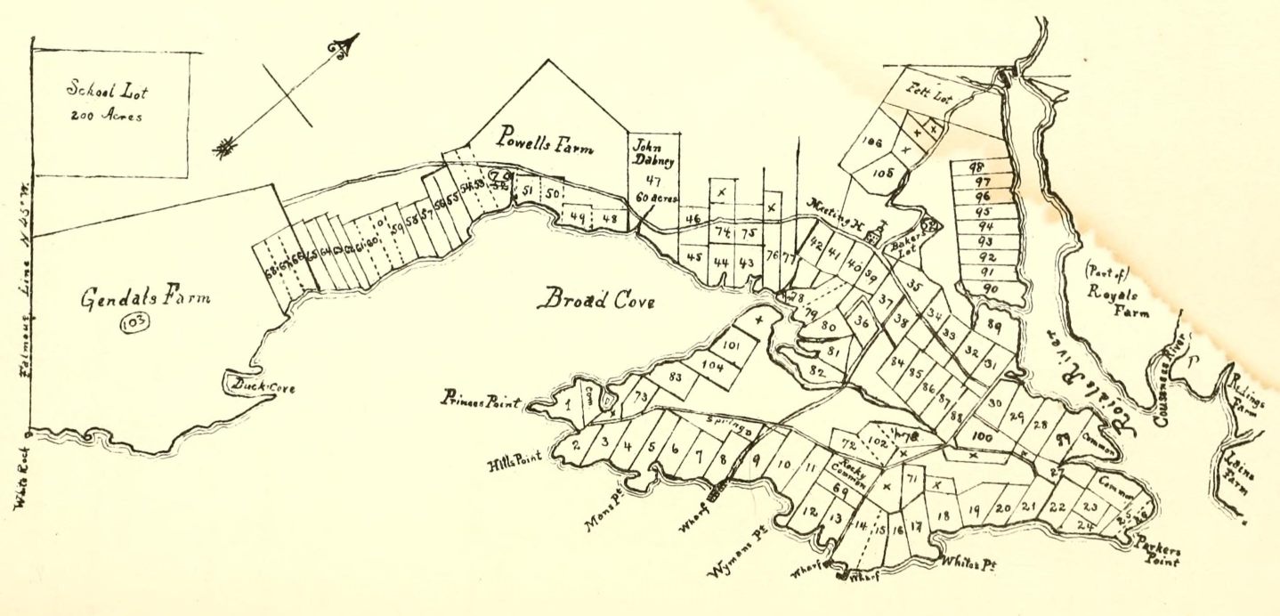
In 1738, "a good road was built over the ledge from the meeting-house to the mills at the first falls which, although it was abandoned about 1800 for a less hilly course, may still be easily traced."[12] Atlantic Highway (now State Route 88; which took a left onto Pleasant Street), Gilman Road, Princes Point Road, Highlands Farm Road (leading to Parker's Point), Drinkwater Point Road (which led to two wharves), Morton Road and Old Town Landing Road (which led to another wharf). Large lot owners at the time included Walter Gendall, whose farm incorporated Duck Cove, beyond Town Landing Road in today's Cumberland Foreside (Cumberland was not incorporated as its own town until 1821). Its dry stone boundary is still intact. Gendall lived there with his wife, Joane.[34] This large farm remained in his possession until his death on September 13, 1688.[34] Welshman John Powell[12] had a farm where today's Schooner Ridge Road is. John Dabney's 60-acre lot abutted this to the east. Dabney was a town selectman in 1737.[63] Felt had a lot at the foot of the northern end of Pleasant Street, adjacent to Stony Brook. Royall's farm, meanwhile, occupied the entire area bisected by Bayview Street.[64]
Smith Street became an uninterrupted offshoot from Pleasant Street, eventually leading to Riverside Cemetery when it was established in 1869, until the Lafayette Street hill was built in the early 19th century.
In 1756, "to accommodate the teams hauling lumber from the great pine forests inland to the seaboard, a new more convenient way was laid out by the way of Walnut Hill and the road constructed."[12]

In 1761, then-Postmaster General Benjamin Franklin ordered milestones placed along the 1673-established route from Boston, Massachusetts, to Machias, Maine, as a northern extension of King's Highway. It was established to address the need for a reliable route between New York and Boston initially, and later between Boston and northern locations. There are six of these stones within Cumberland County,[65] two of which are in Yarmouth: one on Route 88, just south of Ravine Drive on the northern side of the road, and one "1.1 miles" away, outside 148 Pleasant Street. The local section of King's Highway was (heading north) today's Middle Road in Cumberland, then a right onto Tuttle Road, left onto Foreside Road (where a short section of road preserves the name of the original route), then a left onto Pleasant Street, before continuing its way north to Machias.
In 1813, down at the First Falls, "the old road which clambered laboriously over the crest of the hill was replaced by a new street along the head of the wharves below the hill". This is today's Lafayette Street hill, which drops about fifty feet from its crest to its base. (It was named Lafayette Street in honor of General Lafayette, who once stayed in the three-story building at 51 East Main Street.)[12]
By 1847, Portland Street was in full swing, including the Elm Street offshoot that headed directly into the Upper Village. Main Street was, by now, well established.[66]

Roswell P. Greeley established an express service between Portland and Yarmouth, employing a span of horses and large wagons.[15] Azel Kingsley ran a supplemental service minus the horses.[15] It ran two services in each direction: southbound at 7.30 and 11.30 AM and northbound at 3.00 and 5.00 PM.[15]
"Paved roads and automobiles came to Yarmouth in 1914," wrote Alan M. Hall. "The new federal highway from Portland to Bath included four miles from Pleasant Street to the Freeport line."[67]
State Route 115, Yarmouth's Main Street, was officially designated in 1925.[68]
U.S. Route 1 arrived in the late 1940s, at grade and also a bridge over Main Street, shortly after the conclusion of World War II.
Route 88, meanwhile, follows the course of Route 1's predecessor, the Atlantic Highway.[69] A 1944 map shows Atlantic, coming through town, aligning with what became Route 88 up to the point they meet at the end of Spring Street.[70] Prior to the installation of U.S. Route 1, today's curve of Route 88 as it passes Cumberland Farms instead continued directly north-east towards Cousins River. The section of Atlantic Highway that runs from Princes Point Road to the northern end of Pleasant Street was laid in the late 1920s.
In 1961, the Yarmouth section of Interstate 295 was built. It runs elevated through town (including, in controversial fashion, over the harborside at Lower Falls). It has two exits (15 and 17) in the town. Exit 15 became a four-ramp intersection in July 2013, when a northbound on-ramp was added.[71] Exit 17 remains a two-ramp intersection.
Rail


The town has two railroad junctions: Royal Junction (midway along Greely Road) and Yarmouth Junction (to the west of East Elm Street at Depot Road; its station is now gone). The two railroads passing through the town are the St. Lawrence and Atlantic Railroad (formerly Grand Trunk Railway; arrived in 1848) and Guilford Rail System's Kennebec & Portland (later Maine Central Railroad; 1849). A train wreck occurred on the morning of February 15, 1912, near Dunn's Corner (the North Road and Route 9 intersection). A westbound freight train was backing its 25 cars into a siding when a Portland-bound freight train ignored orders to slow down. The collision "drove both engines thirty feet into the air" and ignited tons of wheat and wooden boxcars. There were three fatalities and several injuries. Despite this, Yarmouth was the last stretch of the Grand Trunk to receive automatic block signals in 1924.
The Brunswick Branch of the Maine Central Railroad received a new lease of life in November 2012, when a northern extension of the Downeaster line was opened, carrying passengers five times a day (four on weekends) to and from Brunswick's Maine Street Station. The trains pass under two roads and over three crossings on their way through Yarmouth. They are (from south to north) West Main Street (overpass, just after Royal Junction), Sligo Road (road crossing), East Elm Street (road crossing, just after Yarmouth Junction), North Road (road crossing) and Granite Street (overpass).
Trolley cars of the Portland and Yarmouth Electric Railway Company used to run, every fifteen minutes, from Portland, through Falmouth Foreside, up and down Pleasant Street and onto Main Street between 1898 and 1933,[73] when the advent of the automobile made rail travel a less convenient option. Underwood Spring Park in Falmouth Foreside, with its open-air theater, casino and gazebo, was a popular gathering spot serviced by the trolley cars. The theater only existed for eight years, burning down in 1907.[74] In 1906, a bridge was built over the Royal River, connecting the Brunswick and Portland trolleys at the Grand Trunk depot in town. The tracks ran down what is today's walkers' path to the Rowe School. The pedestrian bridge in the Royal River Park is built on old abutments for a trolley line which ran between Yarmouth and Freeport between 1906 and 1933.
Bus
The only bus route that services the town is Greater Portland Metro’s BREEZ. It has eleven southbound services to Portland and twelve northbound services to Brunswick on weekdays and an abbreviated Saturday schedule. There is no service on Sundays.
On weekdays, the first southbound service arrives in Yarmouth at around 6.20 AM and the last one at around 8.45 PM. The first northbound service arrives at around 6.45 AM and the last one at around 9.50 PM.
On weekends, the first of six southbound services arrives at around 9.45 AM and the last one at around 8.55 PM. The first of seven northbound services arrives at around 8.30 AM and the last one at around 10.00 PM.
There are three bus stop locations: the park and ride lot at the southbound exit 15 ramp of I-295, on Main Street in front of Yarmouth Town Hall, and on either side of Route 1 at Hannaford.
Recreation
Parks

- Grist Mill Park, East Main Street
- Village Green Park, Main Street
- Latchstring Park, Main Street and West Elm Street
- Royal River Park
- Pratt's Brook Park, North Road
Open spaces and conservation land
- Grist Mill Lane Field[75] (formerly an intervale owned by Edward Russell before 1836)
- Spear Farm Estuary Preserve, Bayview Street[76]
- Fels-Groves Farm Preserve, Gilman Road[77]
- Larrabee's Landing, Burbank Lane
- Frank Knight Forest, East Main Street
- Barker Preserve, between East Elm Street and Royal River
- Sligo Road Property
- Sweetsir Farm, Old Field Road
- Camp SOCI, Sandy Point Road, Cousins Island (established in 1957)
- Sandy Point Beach, Cousins Street, Cousins Island
- Katherine Tinker Preserve, Seal Lane, Cousins Island
- Littlejohn Island Preserve, Pemasong Lane, Littlejohn Island[78]
Trails
Beth Condon Memorial Pathway
The Beth Condon Memorial Pathway is a pedestrian and bicycle path that originates on the western side of the Portland Street and Route 1 intersection. It is named after 15-year-old Yarmouth High School sophomore Elizabeth Ann "Beth" Condon, who was killed by drunk driver Martha Burke on August 28, 1993, as she walked along Route 1 with her boyfriend, James Young, having just been to a video store in Yarmouth Marketplace. Burke's car swerved into the breakdown lane, and while Young managed to avoid the car, Condon was hit and thrown 65 feet over the guardrail and down an embankment. Burke pleaded guilty to manslaughter and was sentenced to twelve years, with eight years suspended.[79]
The first section of the pathway was begun in 1997 and cost $100,000. 80% of this was funded by the Maine Department of Transportation.[79] This original part runs north from Lane's Crossing parallel to Route 1 and ends at the parking lot of the town hall. It is at this juncture, where Condon died, that a butterfly garden was built in her honor. It was rededicated on August 2, 2014, a few weeks before the 21st anniversary of her death.[80] In 1998, an extension was added to the pathway that took it onto Cleaves Street, School Street and into the Royal River Park, where it intersects with a recreational path. A pedestrian bridge carries it over the Royal River en route to Forest Falls Drive. In 2006, a third phase added a section that took it up to the Hannaford plaza and, after an almost 500-yard gap, a ramp connecting Route 1 up the hill to East Main Street. Talk of bridging this gap, part of which goes beneath the East Main Street bridge, began in 2011, with a planned start date of 2013.[81] It would bring the total length of the pathway to 1.7 miles;[79] however, the traffic cones that were set out along the route on July 22, 2013, remained in place until September 2014, despite a statement that the original plan to monitor traffic flow was to take "several weeks".[79] The two-lane southbound side of the road was permanently reduced to one at the same time.[79] The project was completed the following month.
In 2000, the pathway was integrated as part of the East Coast Greenway, a project to create a nearly 3,000-mile (4,800-km) urban path linking the major cities of the Atlantic coast, from Calais, Maine, to Key West, Florida, for non-motorized human transportation.
Churches


There are eight churches in Yarmouth. Four of these are located on Main Street. They are (from east to west):
- First Universalist, 97 Main Street (built 1860). Designed by Thomas Holt for an Orthodox Congregational parish; became its current denomination in 1886. The site was formerly occupied by Jenks's Tavern
- First Parish Congregational, 116 Main Street (built 1867). Designed by Portland architect George M. Harding. The third incarnation of churches built for the town's Congregationalists. Charles Augustus Aiken was ordained a pastor here in 1854
- Sacred Heart Catholic, 326 Main Street (built 1929 from granite quarried in North Yarmouth)
- First Baptist, 346 Main Street (built 1889; designed by John Calvin Stevens)[82]

Elsewhere, the North Yarmouth and Freeport Baptist Meeting House (known locally as the Meetinghouse on the Hill) on Hillside Street was built in 1796. It has been twice altered: by Samuel Melcher in 1825 and by Anthony Raymond twelve years later. It ceased being used as a church in 1889, when its congregation moved to the structure now on Main Street. The 1805 bell was transferred to the new home. The meeting house was unused for less than a year. It was purchased for $1,000 and converted into the town's first library and antiquarian society and known as Yarmouth Memorial Hall. It was donated to the town in 1910 and used for town meetings until 1946, at which point they were moved to the Log Cabin on Main Street. During World War II, the belfry was used an airplane-spotting outlook post in the Civil Defense System. Twelve townsfolk per day manned the tower in two-hour shifts. In 1946, the Village Improvement Society (founded in 1911) agreed to maintain the interior of the meeting house. In 2001, the town and the society restored the building, from its granite foundation to the barrel-vaulted ceiling. A non-denominational church service is held here during the town's Clam Festival.[83] The building is owned by the Yarmouth Village Improvement Society.
St. Bartholomew's Episcopal is at 396 Gilman Road, heading towards Cousins Island. It was built in 1988.[84]
Royal River Baptist Church is in Yarmouth Marketplace at 438 Route One.
Cousins Island Chapel (1895) has been holding non-denominational services since 1954 in a former Baptist church.[84]

The Church of the Nazarene on Route 1 became inactive in June 2012 and was demolished in the spring of 2015.
Graveyards and cemeteries

The only graveyard (that is, a burial ground associated with a church) in Yarmouth is located beside the Meeting House on Hillside Street. It is known as the Old Baptist Cemetery.
Two cemeteries are located near the former site of the "Old Ledge" Meeting House on Gilman Road: a 1731 Pioneer burial ground (also known as the Indian Fighters cemetery), which was the first public burial place in Old North Yarmouth, and the 1770 Ledge cemetery (some headstones bear dates earlier than 1770, for many bodies were removed from the older cemetery).[12] The family of Captain Nicholas Drinkwater, Jr. is buried in the latter location, in a communal plot also containing his wife, Margaret, his son, Joshua, and Joshua's wife and Boston native, Harriet. Their daughter, Elizabeth, is interred in Riverside Cemetery with her daughter, Alfreda, and husband, Alfred, who died just before their daughter was born.
Two other cemeteries in town — Riverside and Holy Cross — are located adjacent to each other, at the eastern end of Smith Street. It is in the 1869-founded Riverside Cemetery that several prominent early business owners and other townspeople are buried, including Leon Gorman. Holy Cross, a Catholic-denomination cemetery, is affiliated with Falmouth's Parish of the Holy Eucharist.[85] The Jacob Mitchell garrison was located at the rear of Holy Cross.[86] The dirt path that looks like it leads to the water is actually the original stage road. Mitchell's family lived in the house between around 1729 and 1799. It then became the home of the Whitcombs, whose name is preserved on a street name off Princes Point Road. It was demolished about 1900 and the farm land was purchased in 1916 to become Holy Cross cemetery.[12]
Davis Cemetery is located on the section of Granite Street to the south of East Main Street and Old County Road, an area known as Sodom historically. John Davis (d. 1798) is the oldest known burial in the cemetery.[13]
Cousins Island Cemetery is located at the corner of Cousins Street and Hillcrest Avenue on the island. There are around eighteen unmarked graves of early settlers here. There is also a small cemetery, known as Hill Cemetery, within the confines of the adjacent Tinker Preserve.
Media
An early town newspaper was the Eastern Gazette, which was first printed by E.G. Crabtree in July 1886. His office was in the second story of the Vining store. Financial support was not forthcoming, however, and its life was short.[12]
The town later had its own page, the Yarmouth Gazette, in the "lost but not forgotten institution",[12] the Six Town Times,[87] which was published weekly from 1892 until 1916.[88]
Yarmouth news is now reported regularly in a number of different newspapers, including the Portland Press Herald, The Notes, and The Forecaster (Northern Edition).
The town is home to one radio station: WYAR, which broadcasts from Cousins Island.
Yarmouth Clam Festival

Established in 1965, the Yarmouth Clam Festival is an annual three-day event which takes place in the town during the third weekend in July, attracting around 120,000 people. The festival features a parade, food, carnival rides, crafts, a clam-shucking contest, a five-mile run, and a world-class bike race.

"Herbie"
"Herbie" was an elm tree that stood by present-day East Main Street (Route 88), at its intersection with Yankee Drive, between 1793 and 2010.[89] At 110 feet in height, it was, between 1997 and the date of its felling,[90] the oldest[46] and largest[91] of its kind in New England.[92] The tree, which partially stood in the front yard of a private residence, also had a 20-foot circumference and (until mid-2008) a 93-foot crown spread.[92]
Pownal native Frank Knight, Herbie's "warden", died in May 2012 at the age of 103. He looked after the tree for over fifty years.[93] Frank Knight Forest, on East Main Street, was named in his honor.
Crime
Yarmouth is safer than 77% of U.S. cities. Violent crime is well below the national average for all communities of all population sizes.[94]
Condon family
On the evening of September 28, 1981, John Condon murdered Maureen and James Austin — his sister and brother-in-law — and their 12-year-old son, Douglas, in their Yarmouth home, at 21 Seaborne Drive. The adult couple sustained multiple stab wounds and the child's throat was slashed twice. A fire was set in an upstairs bedroom.[95][96]
Later that night, Condon was stopped by South Portland police when he was suspected of operating his vehicle under the influence of alcohol.[95] He passed a sobriety test but was arrested for driving without a license.
On October 7, a Cumberland County grand jury returned an indictment charging Condon with three counts of murder, one count of arson and two counts of theft. Condon plead not guilty and not guilty by reason of insanity.
A jury trial two years later resulted in convictions on all counts.[95]
In 2018, Condon, then 69 years old, claimed he was treated unfairly by the Maine State Prison. He waged a legal battle in federal court, seeking money for being moved outside Maine.[97]
Notable people
|
|
See also
References
- Specific
- ^ a b "US Gazetteer files 2010". United States Census Bureau. Retrieved 2012-12-16.
- ^ a b "American FactFinder". United States Census Bureau. Retrieved 2012-12-16.
- ^ United States Census Bureau - QuickFacts, Yarmouth town, Cumberland County, Maine; Maine
- ^ a b c d e f g Yarmouth Historical Society, via the Yarmouth/North Yarmouth Community Guide, Portland Press Herald, Summer 2007
- ^ The First Falls - Yarmouth's town website
- ^ The Sayward Family, Charles Augustus Sayward - Google Books
- ^ Second Falls Archived 2016-01-13 at the Wayback Machine - Yarmouth's town website
- ^ Third Falls Archived 2016-01-13 at the Wayback Machine - Yarmouth's town website
- ^ Fourth Falls Archived 2016-01-13 at the Wayback Machine - Yarmouth's town website
- ^ a b c d Architectural Survey Yarmouth, ME (Phase One, September, 2018 - Yarmouth's town website)
- ^ "Pumgustuk Fire Company, Yarmouth, ca. 1900" - Maine Memory Network
- ^ a b c d e f g h i j k l m n o p q r s t u v w x y z aa ab ac ad ae Ancient North Yarmouth and Yarmouth, Maine 1636-1936: A History, William Hutchison Rowe (1937)
- ^ a b c d e f g h i j Yarmouth Revisited, Amy Aldredge
- ^ Yale Cordage - About Us
- ^ a b c d Reminiscences of a Yarmouth Schoolboy, Edward Clarence Plummer (Marks Printing House, 1926)
- ^ "Sappi North America formally dropping the S.D. Warren Co. name" - Portland Press Herald, September 5, 2018
- ^ Bouchard, Kelley (March 2012). "Yarmouth history center to break ground in April". Portland Press Herald.
- ^ "Yarmouth Historical Society opens new History Center" - The Forecaster, January 22, 2013
- ^ Images of America: Yarmouth, Alan M. Hall (Arcadia, 2002), p.101
- ^ "Water Works History"
- ^ a b "A Brief History of Public Water in Yarmouth, Maine" - Yarmouth Water District
- ^ Portland Board of Trade Journal, volume 3
- ^ United States Census Bureau. "Census of Population and Housing". Retrieved September 18, 2013.
- ^ "Minor Civil Division Population Search Results". University of Maine. Archived from the original on September 29, 2011. Retrieved September 18, 2013.
- ^ "Annual Estimates of the Resident Population: April 1, 2010 to July 1, 2012". Archived from the original on October 19, 2013. Retrieved September 18, 2013.
- ^ "Yarmouth Economic Development Advisory Board" - Town of Yarmouth, October 1, 2019
- ^ "American FactFinder". United States Census Bureau. Retrieved 2008-01-31.
- ^ a b Yarmouth Historical Society: The National Register of Historic Places
- ^ "Ancient North Yarmouth and Yarmouth" - Yarmouth Historical Society
- ^ Westcustogo Inn
- ^ a b "Cousins Make Mark on Maine" - banfield-hodgkinsfamily.com
- ^ "A History of Peaks Island and Its People. Also A Short History of House Island, Portland, Maine" - Nathan Goold (1897)
- ^ "The family of man"
- ^ a b c d Captain Walter Gendall, of North Yarmouth, Maine: A Biographical Sketch, Doctor Charles E. Banks (1880) - HathiTrust
- ^ "MaineDOT Projects Under Construction November 27, 2017" - www.maine.gov
- ^ History of Cumberland County, Maine: Town of Cumberland, Everts & Peck, 1880
- ^ North Yarmouth Necrology, 1736–1762) - Rev. Amasa Loring
- ^ "Maine Ulster Scots Project" - Facebook, May 6, 2016
- ^ a b c Maine's Historic Places, Frank Beard (1982)
- ^ The Congregational Quarterly, Volume 13
- ^ "Harvard Medical Alumni Bulletin, Volumes 1-6"
- ^ Water Works History - "Yarmouth, Maine"
- ^ "A Biographical Dictionary of Contemporary American Physicians and Surgeons"
- ^ Cemetery Records at YarmouthMEHistory.org
- ^ Images of America: Yarmouth, Alan M. Hall (Arcadia, 2002), p.6
- ^ a b c Images of America: Yarmouth, Hall, Alan M., Arcadia (2002)
- ^ "Back Then" - Fishermen's Voice
- ^ Images of America: Yarmouth, Alan M. Hall (Arcadia, 2002), p.23
- ^ "Edna May Morrill Obituary" - Legacy.com, August 22, 2007
- ^ DeLorme.com - "Eartha, The World’s Largest Revolving and Rotating Globe"
- ^ "Fans mourn closing of DeLorme’s map store" - Portland Press Herald, February 28, 2016
- ^ About the Muddy Rudder of Yarmouth Maine - MuddyRudder.com
- ^ "Our History" - Yankee Marina & Boatyard
- ^ "Binga's Wingas reopens in Yarmouth; new venture planned in Portland" - The Forecaster, June 5, 2009
- ^ MMWEC.org
- ^ "Is it time to unplug Wyman Station?" - Portland Press Herald, February 17, 2013
- ^ "Patriot Insurance finds a permanent home" - MaineBiz, January 13, 2016
- ^ a b Images of America: Yarmouth, Alan M. Hall (Arcadia, 2002), p.103
- ^ Images of America: Yarmouth, Alan M. Hall (Arcadia, 2002), p.63
- ^ U.S. News and World Report, Best High School Rankings, Yarmouth, Maine
- ^ Images of America: Yarmouth, Alan M. Hall (Arcadia, 2002), p.16
- ^ "Travis Roy Arena at NYA.org". Archived from the original on 2008-07-03. Retrieved 2008-05-29.
- ^ "Selectmen of Old North Yarmouth" - MaineGenealogy.net
- ^ 1741 map of North Yarmouth - MaineGenealogy.net
- ^ "Mile Markers Along the Old King's Highway" - New England History Walks, May 29, 2013
- ^ "Cumberland County 1857" - MaineGenealogy.net
- ^ Images of America: Yarmouth, Alan M. Hall (Arcadia, 2002), p.103
- ^ "Maine State Route 115" Archived 2011-06-12 at archive.today - Floodgap.com
- ^ "US Highway 1 (Maine)" - Floodgap.com
- ^ 1944 map of the area hosted on University of New Hampshire's servers
- ^ "New Yarmouth off-ramp features tighter curve, needs ‘extra grippy’ surface" - Bangor Daily News, September 18, 2013
- ^ "Bank plans ‘concierge’ setup at Yarmouth depot" - Portland Press Herald, October 4, 2018
- ^ Electric railroad route map, ca. 1933 - Maine Memory Network
- ^ "Derailed Trolleys, Yarmouth, ca. 1925" - Maine Memory Network
- ^ "Grist Mill Lane Field - Yarmouth, Maine - YouTube
- ^ "Spear Farm Estuary Preserve" - Royal River Conservation Trust
- ^ "Fels-Groves Farm Preserve" - Royal River Conservation Trust
- ^ "Littlejohn Preserve" - Royal River Conservation Trust
- ^ a b c d e "Pathway with a purpose in Yarmouth: Improvements continue 20 years after Beth Condon's death" Archived 2014-08-06 at archive.today - The Forecaster, August 7, 2013
- ^ "Condon garden to be rededicated in Yarmouth" Archived 2014-08-10 at the Wayback Machine - The Forecaster, July 30, 2014
- ^ "Yarmouth may finish pathway" - Portland Press Herald, August 15, 2011
- ^ Images of America: Yarmouth, Alan M. Hall (Arcadia, 2002), p.28
- ^ "Steeplejacks nail high spire act" - Portland Press Herald, September 22, 2011
- ^ a b "Is there room in Yarmouth for a new church congregation?" - Bangor Daily News, April 23, 2015
- ^ HOLY CROSS CEMETERY
- ^ "Mitchell Garrison" - History of Yarmouth ME
- ^ "National Newspaper Directory and Gazetteer" - Google Books
- ^ "Looking For Volunteers" - Freeport Historical Society
- ^ ""Will elm trees make their way back?" - St. Joseph's College Magazine". Archived from the original on 2008-10-07. Retrieved 2008-02-18.
- ^ According to the plaque on its trunk.
- ^ "Yarmouth braces for Herbie's demise"[permanent dead link] - Portland Press Herald, August 10, 2009
- ^ a b The National Register of Big Trees: 2000-01
- ^ "Frank Knight Dead: 'Herbie' The Elm Tree Caretaker Dies At 103" - Huffington Post, May 14, 2012
- ^ Yarmouth's stats at NeighborhoodScout.com
- ^ a b c State v. Condon, 468 A.2d 1348 (1983)
- ^ "Yarmouth’s fire chief takes a bow" - Portland Press Herald, January 30, 2012
- ^ "Convicted murderer seeks money for being moved outside Maine" - Knox Village Soup, March 12, 2018
- ^ Who Was Who in America, Historical Volume, 1607-1896. Chicago: Marquis Who's Who. 1963.
- ^ "F. Lee Bailey Story". Archived from the original on 2011-01-15. Retrieved 2011-04-02.
- ^ "Hanley Graham Denning" - Portland Press Herald, January 21, 2007
- ^ Obituaries: Helen W. Longley - Bangor Daily News, September 25, 2008
- ^ "Steve Solloway: Ex-player from Maine has felt the fury of a run for the Cup" - Portland Press Herald, June 23, 2013
- General
External links
- Town of Yarmouth official website
- Maine Genealogy: Yarmouth, Cumberland County, Maine
- Yarmouth Historical Society and the Yarmouth History Center
43°48′02″N 70°11′12″W / 43.80056°N 70.18667°W
Municipalities and communities of Cumberland County, Maine, United States | ||
|---|---|---|
| Cities |  | |
| Towns | ||
| CDPs | ||
| Other villages | ||