
Farm to Market Road 669
Farm to Market Road 669 | ||||
|---|---|---|---|---|
| Route information | ||||
| Maintained by TxDOT | ||||
| Length | 68.8 mi[1] (110.7 km) | |||
| Existed | 1945[1]–present | |||
| Major junctions | ||||
| South end | ||||
| North end | ||||
| Location | ||||
| Country | United States | |||
| State | Texas | |||
| Highway system | ||||
| ||||


Farm to Market Road 669 (FM 669) is a Farm to Market Road in West Texas. It extends in a northerly direction for 68.8 miles (111 km)* from Big Spring in Howard County to Post in Garza County.
Beginning at a complex junction with Farm to Market Road 700 and Texas State Highway 350 on the north side of Big Spring, Farm to Market Road 669 initially runs for 15 miles (24 km)* in a northerly direction across the level plains of the Llano Estacado, passing numerous cotton fields and rural farm homes. Near the intersection of FM 1785, FM 669 drops off the Caprock and enters the rolling ranch and oil country of Borden County. The undulating, broken land of Borden County was carved by numerous ephemeral tributaries of the upper Colorado River that typically originate as springs along the Caprock Escarpment to the west and generally flow across the county in an easterly direction.[2]
After crossing the Colorado River, about 5 miles (8 km)* north of the Howard-Borden county line, FM 669 continues north toward Gail, the county seat of Borden County.[3] Near Gail, one passes two prominent erosional remnants of the Llano Estacado. To the south of Gail, one can see a conspicuous landmark known as Mushaway Peak (also known as Muchakooaga, Muchaque Peak or Cordova Peak); this small butte stands on high ground between Grape Creek and Bull Creek, two tributaries of the upper Colorado River.[4] A much larger mesa, called Gail Mountain, stands on the western edge of Gail and provides a scenic backdrop for this small town.[5]
In Gail, FM 669 crosses U.S. Highway 180, which runs west-east from Lamesa to Snyder and beyond. Continuing north, FM 669 draws closer to the edge of the Llano Estacado, which can be seen 5 miles (8 km)* to the west. Approximately 6 miles (10 km)* north of Gail is a junction with FM 2350, which leads to Fluvanna and the Brazos Wind Ranch, to the east.
Farther north, near the Borden-Garza county line, FM 669 reaches a high point that divides the drainage of the upper Brazos and Colorado rivers. Along this drainage divide, the land is highly denuded with many small buttes and hoodoos. Less than a mile north of the county line is a historical marker that describes an archaeological site where the "Garza Point" was first identified. These distinctive arrowheads were constructed from local flint, chert, and obsidian by Native Americans living and hunting in this area around A.D. 1440 to 1500.[6]
Around 5 miles (8 km)* north of the Borden-Garza county line, FM 669 crosses the Double Mountain Fork, a major tributary of the upper Brazos River.[7] From the colorful sandy bed of the Double Mountain Fork, FM 669 climbs 450 feet (137 m)* over a distance of 6 miles (10 km)* as it ascends the Caprock to the high plains of the Llano Estacado. FM 669 remains on the level plains for a short distance of only 3 miles (5 km)* before suddenly dropping off the Caprock and descending 200 feet (61 m)* back to the rolling plains and to the town of Post, the county seat of Garza County. Within the city limits of Post, FM 669 terminates at a junction with U.S. Route 380.[8]
-
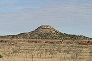 Mushaway Peak, Borden County.
 -

-
 Farm to Market Road 669, Garza County.


See also
References
- ^ a b Transportation Planning and Programming Division (n.d.). "Farm to Market Road No. 669". Highway Designation Files. Texas Department of Transportation.
- ^ Hunt, William R. and Leffler, John. "Borden County". Handbook of Texas Online. Retrieved February 05, 2011.
{{cite web}}: Check date values in:|accessdate=(help)CS1 maint: multiple names: authors list (link) - ^ Hunt, William R. "Gail, TX". Handbook of Texas Online. Retrieved January 31, 2011.
- ^ Anonymous. "Mushaway Peak". Handbook of Texas Online. Retrieved January 28, 2011.
- ^ Anonymous. "Gail Mountain". Handbook of Texas Online. Retrieved February 05, 2011.
{{cite web}}: Check date values in:|accessdate=(help) - ^ Runkles, Frank A. "Garza Site". Handbook of Texas Online. Retrieved February 4, 2011.
- ^ Anonymous. "Double Mountain Fork of the Brazos River". Handbook of Texas Online. Retrieved January 29, 2011.
- ^ Lucko, Paul M. "Post, TX". Handbook of Texas Online. Retrieved January 28, 2011.