
Intramuros
 | |
| City | Manila |
|---|---|
| Population (2000) | 7,466 |
| – Density | 11,099.52 per km² |
| Area | 67.26 hectares |
| – Barangays | 5 |
| – Cong. Districts | 5th District |
Intramuros, located along the southern bank of the Pasig River, was built by the Spaniards in the 16th century and is the oldest district of the city of Manila, the capital of the Philippines. Its name, taken from the Latin, intra muros, literally "Within the walls", meaning within the wall enclosure of the city/fortress, also describes its structure as it is surrounded by thick, high walls and moats. During the Spanish colonial period, Intramuros was considered Manila itself.
History
Pre-hispanic settlement
The site of Intramuros was originally a large Malayan-Islamic settlement named "Maynilad", ruled by three chieftains Rajah Sulayman, Lakan Dula and Rajah Matanda. The name came from "may nilad", "nilad" being a water plant whose star-shaped flowers clustered in abundance along the low-lying riverbanks. The strategic location of Maynilad, being on the Pasig River and the Manila Bay, made it an ideal location for indigenous Tagalog tribes to trade with other Asian civilizations, including Chinese and Islamic merchants who had come from China, Borneo and Indonesia. Maynilad was also the seat of power for native chiefs who ruled the area before Europeans first arrived in Luzon.
Spanish colonial period
In 1564, conquistadors led by Miguel López de Legazpi sailed from New Spain (Mexico) and arrived on the island of Cebu in February 13, 1565. There they established the first Spanish colony in the archipelago. Having heard of rich resources of Manila by local natives, López de Legazpi dispatched two of his Lieutenant-commanders, Martín de Goiti and Juan de Salcedo to explore the northern regions of the Visayas.
In 1570, the Spaniards arrived in the island of Luzon. After quarrels had erupted between the Islamic natives and the Spaniards; Goiti and López de Legazpi's soldiers waged war on the people, before they were able to take control and establish a permanent settlement in the area. In 1571 after the natives were defeated in battle, López de Legazpi made a peace pact with Rajah Sulayman, Rajah Lakandula and Rajah Matanda; who, in return, handed over Manila to the Spaniards.
Citing the rich resources and location of Manila; López de Legazpi declared the area as the new capital of the Spanish colony in the Philippines on June 24, 1571. The King of Spain, delighted at the new conquest achieved by López de Legazpi and his men, awarded the city a coat of arms and declaring it Ciudad Insigne y Siempre Leal ("Distinguished and ever loyal city").
The planning of the city of Manila was commenced by López de Legazpi who had become the first Governor general on the islands. He established forts, roads, churches and schools. The plans for Intramuros were based on King Philip II's Royal Ordinance issued on July 3, 1573 in San Lorenzo, Spain. It's design was based upon a medieval castle structure and covered 64 hectares of land, surrounded by 8 metre thick stones and high walls that rise 22 metres.
Intramuros was completed in 1606 and it served as the center of political, military and religious power of the Spaniards during the time that the Philippines was a colony of Spain. Inside Intramuros; there are several Roman Catholic churches, like the Manila Cathedral and the San Agustin Church, convents and church-run schools, such as the Universidad de Santo Tomás, the Colegio de San Juan de Letran and the Ateneo Municipal de Manila, which were usually being run by religious orders such as the Dominicans, Augustinians, Franciscans and Jesuits. The Governor's Palace, the official residence of the Spanish Viceroyalties to the Philippines was originally in Intramuros before it was officially moved to Malacañang Palace and Fort Santiago. Only Spaniards and Mestizos were allowed to take part on political issues and take residence inside the walled city, Christian natives and Chinese were also allowed inside, but Spanish officials prevented them living there. The vast majority of the natives and Chinese residents lived outside the walled city.
Original building structures
Note: parenthesis () indicates the new buildings that occupies the same site today.
Churches, convents and chapels
- Lourdes Church (El Almanecer)
- Manila Cathedral*
- San Agustin Church*
- Santo Domingo Church (Bank of the Philippine Islands)
- San Francisco Church (Mapúa Institute of Technology)
- San Ignacio Church* (Ruins)
- San Nicolas de Tolentino Church (Manila Bulletin)
- Convento de Sta. Clara (Empty Lot)
- Chapel of the Third Venerable Order (Mapúa Chapel)
Schools
- Ateneo Municipal de Manila (Clamshell 1)
- Beaterio-Colegio de Sta. Catalina (Letran Elementary School)
- Beaterio de la Compañia de Jesus*
- Colegio de San Juan de Letran*
- Colegio de Sta. Isabel (Clamshell 2)
- Colegio de Sta. Rosa*
- Manila High School*
- Universidad de Sto. Tomás (BF Condominium)
- Universidad Maximo de San Ignacio (Pamantasan ng Lungsod ng Maynila)
Other buildings
- Palacio del Gobernador* (Commission on Elections)
- Audiencia (former Supreme Court building and the Old Commission on Elections*)[1] (Ruins)
- Ayuntamiento* (Ruins)
- Hospital de San Juan de Dios (Lyceum of the Philippines University)
- Intedencia* (Ruins)
- Palacio Arzobispal*
- Palacio de Sta. Potenciana (Philippine Red Cross)
World War II
During World War II, much of Intramuros was damaged by bombings from both Japanese, American and Filipino soldiers who besieged on it.
In 1945, Japanese soldiers who had occupied the islands, invaded the site of Intramuros, killed many civilians and Filipino soldiers; destroying most of the original buildings contructed. Almost 100,000 people died during the liberation of Manila. Intramuros was in ruins after the war and the only structure that survived was the San Agustin; almost no other buildings remained standing.
Present day Intramuros
In the 1980s, under the direction of former Philippine First Lady Imelda Marcos, the Intramuros Administration restored the city and at present the walled city is the only district of Manila where old Spanish-era influences were retained. Much of the development of present-day Manila occurred outside the gates of Intramuros, leaving the old walls, streets and churches of Intramuros minimally touched by modernization, although outlets of Jollibee, McDonald's and Starbucks now sit alongside distinguished educational institutions within its walls. The old moats that surrounded Intramuros have been filled up and transformed into a golf course where locals and foreign nationals play the sport. The garrison that was Fort Santiago is now a tourist spot where visitors can enjoy the nostalgic romance of a bygone Spanish era within its gardens.
.jpg)
Intramuros now houses some of the higher education institutions in the Philippines. These are the city-owned Pamantasan ng Lungsod ng Maynila, the technical school Mapúa Institute of Technology, Lyceum of the Philippines University, Colegio de San Juan de Letran and high schools such as the Manila High School,and Colegio de Santa Rosa.
There are also places in Intramuros called Baluartes. Baluarte is a Spanish word for "bastion". These places are strongholds of Spaniards during the Spanish era. There are notable baluartes in Intramuros such as Baluarte de San Diego, Baluarte de San Gabriel, Baluarte de Sta Barbara and Baluarte de San Andres. Also Intramuros is also restoring its old "Puerta" or "Gates" which was the main entrance to the walled city.
Illegal Settlers or Squatters makes 70% of the entire Intramuros Population. Their Toilet is usaully the Sentry Tower of the wall
Intramuros images
-
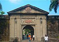 Puerta de Parian
 -
Puerta Isabela II
-
Palacio del Gobernador
-
 Manila Cathderal
 -
 Fort Santiago
 -
 Reducto de San Pedro
 -
 Plaza dela Fuerza
 -
 Casa Manila
 -
 Plaza de Roma, with the statue of King Carlos IV of Spain
 -
Statue of Philip II of Spain in Intramuros


References
External links
- Philippine Convention and Visitors Corporation Intramuros Map
- WowPhilippines Intramuros Virtual Map
- Intramuros Photos
- Explore Intramuros!
| Topics |  | |
|---|---|---|
| Government | ||
| Districts | ||
| Mixed-use developments | ||
| Beaches | ||
| Legislative districts | ||