
Vratsa
Vratsa
Враца | |
|---|---|
Town | |
 | |
 Coat of arms | |
| Motto(s): Vratsa, city like the Balkan - ancient and young. (Враца, град като Балкана - древен и млад.) | |
 Vratsa Location of Vratsa  Vratsa Vratsa (Balkans) | |
| Coordinates: 43°12′N 23°33′E / 43.200°N 23.550°E | |
| Country | Bulgaria |
| Province | Vratsa |
| Government | |
| • Mayor | Kalin Kamenov (GERB) |
| Area | |
| • Town | 212 km2 (82 sq mi) |
| Elevation | 344 m (1,129 ft) |
| Population | |
| • Town | 50,012 |
| • Density | 240/km2 (610/sq mi) |
| • Urban | 61,702 |
| Time zone | UTC+2 (EET) |
| • Summer (DST) | UTC+3 (EEST) |
| Postal Code | 3000 |
| Area code | 092 |
| Website | Official website |
Vratsa (Bulgarian: Враца [ˈvrat͡sɐ]) is the largest city in northwestern Bulgaria and the administrative and economic centre of the municipality of Vratsa and Vratsa district. It is located about 112 km north of Sofia, 40 km southeast of Montana.
Situated at the foot of the Vrachanski Balkan, the town is near numerous caves, waterfalls and rock formations. The most famous of them are the Ledenika Cave, Skaklya Waterfall and the Vratsata Pass.
The Vratsa History Museum holds the Rogozen treasure, which is the largest Thracian treasure.
Botev Days are held annually in the city, culminating in the rally-dawn on June 1, held at Hristo Botev Square, as well as the national worship on June 2 at Mount Okolchitsa.
Vratsa's motto is "A city like the Balkan - ancient and young".
Name
The name comes from the Vratsata Pass nearby, and derives from the Slavic word vrata ("gate") + the Slavic diminutive placename suffix -itsa, "little gate",[2] used to translate the Latin name Valve ("double door").
Geography
.jpg)
The city of Vratsa is located in the foothills of "Vrachanski Balkan" (Vratsa Mountain), on the banks of Leva River, 116 km from the national capital Sofia.
The area has diverse natural features. Several protected natural attractions and historical monuments are located on the territory of the Vratsa State Forestry.
Climate
The climate is humid continental, similar to that of Sofia. The average annual temperature is about 11 °C (52 °F). Climate in this area has mild differences between highs and lows, and there is adequate rainfall year-round. The Köppen Climate Classification subtype for this climate is "Cfb" (Marine West Coast Climate/Oceanic climate).[3]
Population
The number of the residents of the city reached its peak in the period 1990-1991 when it exceeded 85,000.[4] As of February 2011, the town has a population of 60,692 inhabitants.[5] The following table presents the change of the population after 1887.
| Vratsa | |||||||||||||||
|---|---|---|---|---|---|---|---|---|---|---|---|---|---|---|---|
| Year | 1887 | 1910 | 1934 | 1946 | 1956 | 1965 | 1975 | 1985 | 1992 | 2001 | 2005 | 2009 | 2011 | 2021 | |
| Population | 11,323 | 15,250 | 16,177 | 19,620 | 26,582 | 39,091 | 61,134 | 75,451 | 75,518 | 68,975 | 63,260 | 61,011 | 60,692 | 50,012 | |
| Highest number 85,272 in 1990 | |||||||||||||||
| Sources: National Statistical Institute,[5][4][6][1] citypopulation.de,[7] pop-stat.mashke.org,[8] Bulgarian Academy of Sciences[9] | |||||||||||||||

Ethnic, linguistic and religious composition
According to the latest 2011 census data, the individuals declared their ethnic identity were distributed as follows:[10][11]
- Bulgarians: 53,275 (97.3%)
- Roma: 1,045 (1.9%)
- Turks: 54 (0.1%)
- Others: 185 (0.3%)
- Indefinable: 216 (0.4%)
- Undeclared: 5,937 (9.8%)
Total: 60,692
The ethnic composition of Vratsa Municipality is 64334 Bulgarians and 2215 Gypsies among others.
History


Vratsa is an ancient city found by ancient Thracians. Vratsa was called Valve ("door of a fortress") by the Romans due to a narrow passage where the main gate of the city fortress was located. Nowadays, this passage is the symbol of Vratsa, and is shown on the town's Coat of arms.
After the fall of Rome, Vratsa became part of the Eastern Roman Empire (Byzantium).
At the end of the 6th century AD, Vratsa was populated by the South Slavic tribes. Even if they came from Pannonia and Dacia on the north, the town remained under Byzantine rule.
In the 7th century, the Bulgars and the Slavs found the First Bulgarian Empire and the Slavic Vratsa became part of it. The city grew into important strategic location because of its proximity to the South State border. Vratsa became famous for its goldsmiths and silversmiths production and trade, high-quality earthenware and military significance.
In the 8th century, the Bulgarian army captured Sofia, which led to the decreasing of Vratsa's importance because of the better strategic position of Sofia, its more developed economy and larger size. But Vratsa was again key for the resistance against the Byzantine, Serbian and Magyar invasions in the Middle Ages.
On 1 May 1966 in the village of Sgorigrad, a Mir-Plakanista mine tailings dam collapsed, causing a flood of mud and debris that killed 488 people. It remains one of the biggest disasters in Vratsa since the September 30, 1923 fire and the Anglo-American bombing of January 23, 1944.
Tourism

The mountains and forests are suitable for development of different types of tourism — hunting and fishing, skiing, speleology, delta-gliding, photo-tourism, etc.
Good opportunities exist for exercising different sport activities such as mountaineering, bicycle sport and for those who enjoy being thrilled can go for hanggliding and paragliding, or set out for carting, buggy and motocross racing tracks.
Conditions are provided for rest and entertainment — children's and adults' swimming pools, water cycles, discos, bars, restaurants, excellent hotel facilities and good service. To accommodate winter sports enthusiasts, there are rope lines near the Parshevitsa Chalet, and the skiing tracks are said to be well maintained.
There are also a Museum of History and an Ethnographic and Revival Complex.
Climate
Vratsa has a humid continental climate (Dfa).
| Climate data for Vratsa (2002-2012) | |||||||||||||
|---|---|---|---|---|---|---|---|---|---|---|---|---|---|
| Month | Jan | Feb | Mar | Apr | May | Jun | Jul | Aug | Sep | Oct | Nov | Dec | Year |
| Mean daily maximum °C (°F) | 3.2 (37.8) |
5.8 (42.4) |
11.0 (51.8) |
17.5 (63.5) |
23.1 (73.6) |
26.8 (80.2) |
29.5 (85.1) |
29.7 (85.5) |
25.3 (77.5) |
18.4 (65.1) |
11.6 (52.9) |
5.3 (41.5) |
17.3 (63.1) |
| Daily mean °C (°F) | −0.6 (30.9) |
1.6 (34.9) |
6.4 (43.5) |
12.5 (54.5) |
18.1 (64.6) |
21.8 (71.2) |
24.1 (75.4) |
24.1 (75.4) |
20.0 (68.0) |
13.5 (56.3) |
7.9 (46.2) |
1.8 (35.2) |
12.6 (54.7) |
| Mean daily minimum °C (°F) | −4.3 (24.3) |
−2.7 (27.1) |
1.8 (35.2) |
7.5 (45.5) |
12.1 (53.8) |
15.8 (60.4) |
17.7 (63.9) |
17.5 (63.5) |
13.6 (56.5) |
8.5 (47.3) |
3.7 (38.7) |
−1.4 (29.5) |
7.5 (45.5) |
| Average precipitation mm (inches) | 48 (1.9) |
41 (1.6) |
52 (2.0) |
71 (2.8) |
112 (4.4) |
106 (4.2) |
78 (3.1) |
61 (2.4) |
59 (2.3) |
65 (2.6) |
62 (2.4) |
54 (2.1) |
809 (31.9) |
| Source: Stringmeteo.org | |||||||||||||
Main sights

Ledenika cave
Ledenika is the most frequently visited Bulgarian cave.
Ledenika is located in the Stresherski part of the Vratsa mountain. Its entrance being at 830m above sea level. It features an abundance of galleries and impressive karst formations including stalactites and stalagmites, dating back a thousand years. The cave is about 300m long and contains ten separate halls. The cave is part of the 100 Tourist Sites of Bulgaria
Vratsata Gorge
Vratsata Gorge – the highest cliffs on the Balkan Peninsula (400 meters high).
Vratsata Gorge is situated in Vratsa Mountain. The area is easily accessible from Vratsa.
The limestone of Vratsata Central Wall and the other rocks offer many possibilities for climbing and alpinism, connected by more than 70 alpine routes of all categories of difficulty.
Skaklya waterfall
Skaklya waterfall - highest temporary waterfall in Bulgaria and the Balkans - 141 meters.
Regional historical museum

Regional historical museum in Vratsa preserves the Rogozen Treasure - the biggest Thracian treasure that was ever discovered on the territory of Bulgaria[12][13]
The main building of the museum houses several exhibitions.
- Prehistory Hall
- Antiquity Hall
- The Middle Ages Hall
- The Thracian Treasures Hall
- The Rogozen Treasure Hall
- Hristo Botev exhibition Hall
- New History Hall
- Stone arc Hall
- Lapidarium.
Panoramic Views


Transport

The strategic location of Vratsa is determined by the major rail and road corridors. Its geographical position became even more important with the construction of the Danube Bridge 2 at the town of Vidin (providing the most direct land access from the Thessaloniki port and Sofia towards Western Europe). Vratsa connects to the villages and city within the region and throughout the country by bus and railway transport. There are regular bus lines to Sofia, Pleven, Vidin, Montana, Kozloduy, Oryahovo, Mezdra (at short intervals), as well as to the smaller villages, scattered around the city. The bus station is located on the way between the railway station and the centre of the city. Vratsa is an important railway station along the railway route Sofia — Vidin (Lom).
Honour
Vratsa Peak on Greenwich Island in the South Shetland Islands, Antarctica is named after Vratsa.
In popular culture
Vratsa is the home of a professional Quidditch team operating within the fictional Harry Potter universe. The Vratsa Vultures have won the European Cup seven times.[14]
Economy
Industry
In the area of Vratsa are developed many branches of industry: textile (production of cotton fabrics and silk), tailoring, food processing (bakery, confectionery, meat processing, dairy processing, soft drinks production, etc.) mining of rock lining materials from the Vratsa region - limestone), furniture, light, machine-building (production of lathes and mills), metal casting and metalworking, etc.
Sport

Twin towns - sister cities
Vratsa is twinned with:[15]
Gallery
-
 Ledenika cave
 -
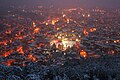 Vratsa by night
 -
 Vratsata gorge
 -
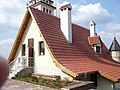
 Street scene
 -
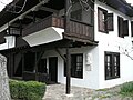 Ethnographic complex
 -
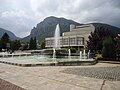 Theatre
 -
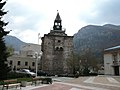
 Medieval Tower of Kurt Pasha
 -
 Medieval tower
 -
 Tourist centre
 -
 School
 -
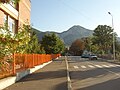 Street in Vratsa
 -
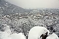 Vratsa in the winter
.JPG)


References
- ^ a b https://nsi.bg/bg/content/2975/%D0%BD%D0%B0%D1%81%D0%B5%D0%BB%D0%B5%D0%BD%D0%B8%D0%B5-%D0%BF%D0%BE-%D0%BE%D0%B1%D0%BB%D0%B0%D1%81%D1%82%D0%B8-%D0%BE%D0%B1%D1%89%D0%B8%D0%BD%D0%B8-%D0%BC%D0%B5%D1%81%D1%82%D0%BE%D0%B6%D0%B8%D0%B2%D0%B5%D0%B5%D0%BD%D0%B5-%D0%B8-%D0%BF%D0%BE%D0%BB
- ^ "Враца— кратка справка" (in Bulgarian). PureBulgaria. Retrieved 2008-09-14.
- ^ "Vratsa, Bulgaria Köppen Climate Classification (Weatherbase)". Weatherbase.
- ^ a b (in Bulgarian)National Statistical Institute - Towns population 1956-1992[permanent dead link]
- ^ a b (in Bulgarian)National Statistical Institute - Main Towns Census 2011 Archived 2011-04-08 at the Wayback Machine
- ^ (in English) Bulgarian National Statistical Institute - towns in 2009
- ^ (in English) „WorldCityPopulation“
- ^ "Cities of Bulgaria". mashke.org.
- ^ (in Bulgarian) Bulgarian Academy of Sciences Archived 2011-07-06 at the Wayback Machine
- ^ (in Bulgarian) Population on 01.02.2011 by provinces, municipalities, settlements and age; National Statistical Institute
- ^ Population by province, municipality, settlement and ethnic identification, by 01.02.2011; Bulgarian National Statistical Institute (in Bulgarian)
- ^ "ovo.bg". vratsamuseum.ovo.bg.
- ^ "Регионален исторически музей - Враца". Facebook.
- ^ Whisp, Kennilworthy (2001). Quidditch Through the Ages. WhizzHard Books. pp. 31–46. ISBN 1-55192-454-4.
- ^ "Побратимени градове". vratza.bg (in Bulgarian). Vratsa. Retrieved 2019-10-31.
External links
- Vratsa Municipality website
- Hotels in Vratsa (map)
- Vratsa Historical Museum
- “Vrachanski Balkan” Nature Park
- local tourism website www.visitvratsa.com.

| International | |
|---|---|
| National | |
| Geographic | |