
Washington's 3rd congressional district
| Washington's 3rd congressional district | |
|---|---|
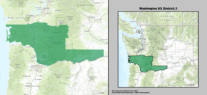
Interactive map of district boundaries since January 3, 2023 (Vancouver's Clark County highlighted, where almost two-thirds of the district's population resides) | |
| Representative | |
| Population (2023) | 792,906 |
| Median household income | $90,563[1] |
| Ethnicity |
|
| Cook PVI | R+5[2] |
.svg)

Washington's 3rd congressional district encompasses the southernmost portion of Western Washington. It includes the counties of Lewis, Pacific, Wahkiakum, Cowlitz, Clark, and Skamania; as well as a small portion of southern Thurston county.
The district is represented by Democrat Marie Gluesenkamp Perez. It was one of five districts that would have voted for Donald Trump in the 2020 presidential election had they existed in their current configuration while being won or held by a Democrat in 2022.[3]
History
[edit]Established after the 1900 census, the 3rd district was represented by Democrats for most of the latter half of the 20th century, until Jolene Unsoeld was defeated by Republican Linda Smith as part of the Republican Revolution of 1994. Smith retired after two terms and was succeeded by Democrat Brian Baird. Baird announced he wouldn't run for re-election in 2010, with Republican Jaime Herrera Beutler winning the seat, during the general election, against Democratic state representative Denny Heck, who was subsequently elected in Washington's 10th congressional district. Herrera Beutler retained her seat over Democrat Jon T. Haugen in 2012. In 2014, she beat Democratic nominee Bob Dingethal.
In presidential elections, the 3rd district is rather competitive. It is the only part of Western Washington to not swing heavily to the Democrats during the 1990s, and it is one of the few districts in the area that cannot be considered safe for either party. It is home to Lewis County, far and away the most conservative county in western Washington. Additionally, most of the district is located in the Portland, Oregon, market; voting patterns there are somewhat different from those in the areas closer to Seattle. George W. Bush narrowly carried the district in 2000 with 48% of the vote and again in 2004 with 50%. The district swung Democratic in 2008, giving Barack Obama 52% of the vote and 46% to John McCain. However, redistricting (see below) extended the district further east and made it slightly more Republican than its predecessor; had the current boundaries been in effect for the 2008 election, Obama would have only defeated McCain by 50.9 percent to 47.1 percent. In 2012, it gave Mitt Romney 49.6% to Obama's 47.9%. In the 2016 presidential election, Republican nominee Donald Trump won the district 49.9% to Hillary Clinton's 42.5%. Trump won every county entirely within the district except Clark County, which he lost by only 316 votes out of over two hundred thousand, including carrying three counties (Pacific, Wahkiakum and Cowlitz) that voted for Walter Mondale in 1984. In 2020, Trump won the district 50.6% to Joe Biden's 46.9%, however, the incumbent Republican Congresswoman, Jaime Herrera Beutler, over-performed the incumbent President, winning the district by a margin of 13%.
2010 redistricting
[edit]The Washington State Redistricting Commission is charged with adjusting congressional and legislative district boundaries after each decennial census. Given Washington State's growth over the prior decade, Washington gained an additional congressional district for the 113th congress. The third district needed to lose 106,894 people in the redistricting process in order to meet the new ideal population of 672,454.[4] On September 13, 2011, the four voting commissioners on the Redistricting Commission submitted draft proposals for the congressional map. All four draft proposals left the entirety of Lewis, Wahkiakum, Cowlitz, and Clark Counties, and all or most of Skamania county in the 3rd district. In addition, each proposal added population from one or more of Pacific, Thurston, Pierce, or Klickitat counties.[5] [6] [7] [8]
The final approved map for the 3rd district included the entirety of Klickitat, Skamania, Clark, Cowlitz, Wahkiakum, Pacific, and Lewis counties, with the extreme southern part of Thurston County south of highway 12, Washington State Route 507, and the Vail Cut Off Road.[9]
2020 redistricting
[edit]Following the 2020 census, the 3rd district was slightly changed during redistricting, losing Klickitat county to the 4th district and gaining an additional small sliver of Thurston county from the 10th district. The new 3rd district was marginally more favorable for Republicans, voting for Trump in 2020 by a margin of 4.2%, as opposed to the old district's 3.7%. Despite this, Democratic challenger Marie Gluesenkamp Pérez bested Republican nominee Joe Kent by 2,629 votes in 2022.[3] It was one of five districts that would have voted for Donald Trump in the 2020 presidential election had they existed in their current configuration while being won or held by a Democrat in 2022.


Recent results from presidential races
[edit]| Year | Office | Results |
|---|---|---|
| 1952 | President | Eisenhower 54 - 46% |
| 1956 | President | Eisenhower 52 - 48% |
| 1960 | President | Kennedy 50 - 50% |
| 1964 | President | Johnson 70 - 30% |
| 1968 | President | Humphrey 52 - 42% |
| 1972 | President | Nixon 58 - 42% |
| 1976 | President | Carter 50 - 46% |
| 1980 | President | Reagan 50 - 38% |
| 1984 | President | Reagan 53 - 45% |
| 1988 | President | Dukakis 51 - 47% |
| 1992 | President | Clinton 42 - 33% |
| 1996 | President | Clinton 49 - 38% |
| 2000 | President | Bush 48 - 47% |
| 2004 | President | Bush 50 - 48% |
| 2008 | President | Obama 52 - 46% |
| 2012 | President | Romney 50 - 48% |
| 2016 | President | Trump 50 - 43% |
| 2020 | President | Trump 51 - 47% |
List of members representing the district
[edit]
.jpg)


.jpg)


_(new_version).svg)
Recent election results
[edit]2010
[edit]| Party | Candidate | Votes | % | |||
|---|---|---|---|---|---|---|
| Republican | Jaime Herrera Beutler | 152,799 | 53.0% | |||
| Democratic | Denny Heck | 135,654 | 47.0% | |||
| Total votes | 288,453 | 100.0% | ||||
| Republican gain from Democratic | ||||||
2012
[edit]| Party | Candidate | Votes | % | |
|---|---|---|---|---|
| Republican | Jaime Herrera Beutler (Incumbent) | 177,446 | 60.4% | |
| Democratic | Jon T. Haugen | 116,438 | 39.6% | |
| Total votes | 293,884 | 100.0% | ||
| Republican hold | ||||
2014
[edit]| Party | Candidate | Votes | % | |
|---|---|---|---|---|
| Republican | Jaime Herrera Beutler (Incumbent) | 124,796 | 61.5% | |
| Democratic | Bob Dingethal | 78,018 | 38.5% | |
| Total votes | 202,814 | 100.0% | ||
| Republican hold | ||||
2016
[edit]| Party | Candidate | Votes | % | |
|---|---|---|---|---|
| Republican | Jaime Herrera Beutler (Incumbent) | 193,457 | 61.8% | |
| Democratic | Jim Moeller | 119,820 | 38.2% | |
| Total votes | 313,277 | 100.0% | ||
| Republican hold | ||||
2018
[edit]| Party | Candidate | Votes | % | |
|---|---|---|---|---|
| Republican | Jaime Herrera Beutler (Incumbent) | 161,819 | 52.7% | |
| Democratic | Carolyn Long | 145,407 | 47.3% | |
| Total votes | 307,226 | 100.0% | ||
| Republican hold | ||||
2020
[edit]| Party | Candidate | Votes | % | |
|---|---|---|---|---|
| Republican | Jaime Herrera Beutler (Incumbent) | 235,579 | 56.4% | |
| Democratic | Carolyn Long | 181,347 | 43.4% | |
| Write-in | 977 | 0.2% | ||
| Total votes | 417,903 | 100.0% | ||
| Republican hold | ||||
2022
[edit]| Party | Candidate | Votes | % | |||
|---|---|---|---|---|---|---|
| Democratic | Marie Gluesenkamp Pérez | 160,323 | 50.1% | |||
| Republican | Joe Kent | 157,690 | 49.3% | |||
| Write-in | 1,760 | 0.5% | ||||
| Total votes | 319,759 | 100.0% | ||||
| Democratic gain from Republican | ||||||
See also
[edit]- 2008 United States House of Representatives elections in Washington
- 2010 United States House of Representatives elections in Washington
- 2012 United States House of Representatives elections in Washington
- 2014 United States House of Representatives elections in Washington
- 2016 United States House of Representatives elections in Washington
- 2018 United States House of Representatives elections in Washington
- 2020 United States House of Representatives elections in Washington
References
[edit]- Specific
- ^ "My Congressional District". United States Census Bureau. Retrieved September 22, 2024.
- ^ "2022 Cook PVI: District Map and List". Cook Political Report. Retrieved January 5, 2023.
- ^ a b c "November 8, 2022 General Election Results". Washington Secretary of State. Retrieved November 27, 2022.
- ^ "2010 Congressional Malapportionment Report" (PDF). Washington State Redistricting Commission. Retrieved September 14, 2011.
- ^ Ceis, Tim. "Draft Congressional Plan #1 - Commissioner Ceis - September 13, 2011" (PDF). Washington State Redistricting Commission. Retrieved September 14, 2011.
- ^ Gorton, Slade. "Draft Congressional Plan #1 - Commissioner Gorton - September 13, 2011" (PDF). Washington State Redistricting Commission. Retrieved September 14, 2011.
- ^ Foster, Dean. "Draft Congressional Plan #1 - Commissioner Foster - September 13, 2011" (PDF). Washington State Redistricting Commission. Retrieved September 14, 2011.
- ^ Huff, Tom. "Draft Congressional Plan #1 - Commissioner Huff - September 13, 2011" (PDF). Washington State Redistricting Commission. Retrieved September 14, 2011.
- ^ "Congressional District 3" (PDF). Washington Redistricting Commission. Retrieved May 6, 2012.
- ^ "Election Search Results - November 1912 General". Washington Secretary of State. Retrieved June 26, 2022.
- ^ "Election Search Results - November 1914 General". Washington Secretary of State. Retrieved June 26, 2022.
- ^ "November 02, 2010 General Election". Secretary of State. State of Washington. Retrieved September 4, 2019.
- ^ "November 06, 2012 General Election". Secretary of State. State of Washington. Retrieved September 4, 2019.
- ^ "November 4, 2014 General Election". Secretary of State. State of Washington. Retrieved September 4, 2019.
- ^ "November 8, 2016 General Election". November 8, 2016 General Election. Washington Secretary of State. Retrieved September 4, 2019.
- ^ "November 6, 2018 General Election Results". Washington Secretary of State. State of Washington. Retrieved September 4, 2019.
- ^ "November 3, 2020 General Election Results". Washington Secretary of State. Retrieved December 4, 2020.
- General
- Martis, Kenneth C. (1989). The Historical Atlas of Political Parties in the United States Congress. New York: Macmillan Publishing Company.
- Martis, Kenneth C. (1982). The Historical Atlas of United States Congressional Districts. New York: Macmillan Publishing Company.
- Congressional Biographical Directory of the United States 1774–present Their final version was approved and sent to the legislature on January 1, 2012.