
Kermanshah: Difference between revisions
revert- unreliable source (and even this unreliable source isn't cited correctly) |
don't remove sourced materials |
||
| Line 118: | Line 118: | ||
'''Kermanshah''' ( {{lang-fa|کرمانشاه}}, ''Kermānshāh'', [[Kurdish language|Kurdish]]: کرماشان ), is the capital city of [[Kermanshah Province]], located 525 km from [[Tehran]] in the western part of [[Iran]] and about 120 km from the border of [[Iraq]]. Kermanshah has a moderate and mountainous climate. The estimated population of the city is 822,921 (year 2005) |
'''Kermanshah''' ( {{lang-fa|کرمانشاه}}, ''Kermānshāh'', [[Kurdish language|Kurdish]]: کرماشان ), is the capital city of [[Kermanshah Province]], located 525 km from [[Tehran]] in the western part of [[Iran]] and about 120 km from the border of [[Iraq]]. Kermanshah has a moderate and mountainous climate. The estimated population of the city is 822,921 (year 2005) |
||
<ref name="Cities in Iran">{{cite web |
<ref name="Cities in Iran">{{cite web |
||
| url =http://www.mongabay.com/igapo/2005_world_city_populations/Iran.html |title =Cities in Iran | year=2005 | accessdate=2008-04-04}}</ref> and the majority of people speak [[ |
| url =http://www.mongabay.com/igapo/2005_world_city_populations/Iran.html |title =Cities in Iran | year=2005 | accessdate=2008-04-04}}</ref> and the majority of people speak [[kurdish language|kurdi]] with Kalhori accent as well as different dialects of [[Kurdish language]] like jafi and howrami.Kurds form majority of population of Kermanshah<ref>[http://www.iranchamber.com/cities/kermanshah/kermanshah.php Iran Chamber society]: Kurds form majority of population of Kermanshah. accessed: March 2010.</ref> The religion of the people is [[Shi'a Islam|Shi'a]] [[Muslim]]. Small numbers of [[Bahá'í Faith|Bahá'ís]], [[Jews]], [[Yarsan]], and [[Armenians]] also living in Kermanshah. |
||
==History== |
==History== |
||
Revision as of 09:34, 15 March 2010
Kermanshah
کرمانشاە، کرماشان | |
|---|---|
 Monuments of Taq-Bostan , carved 4-6th A.D | |
| Country | |
| Province | Kermanshahan |
| Elevation | 1,350 m (4,430 ft) |
| Population (2005) | |
| • City | 822,921 |
| • Metro | 965,665 |
| estimate | |
| Time zone | UTC+3:30 (IRST) |
| Area code | 0831 |
Kermanshah ( Persian: کرمانشاه, Kermānshāh, Kurdish: کرماشان ), is the capital city of Kermanshah Province, located 525 km from Tehran in the western part of Iran and about 120 km from the border of Iraq. Kermanshah has a moderate and mountainous climate. The estimated population of the city is 822,921 (year 2005) [1] and the majority of people speak kurdi with Kalhori accent as well as different dialects of Kurdish language like jafi and howrami.Kurds form majority of population of Kermanshah[2] The religion of the people is Shi'a Muslim. Small numbers of Bahá'ís, Jews, Yarsan, and Armenians also living in Kermanshah.
History

Given its antiquity, attractive landscapes and rich culture, Kermanshah is considered as one of the cradles of prehistoric cultures such as Neolithic villages. According to archaeological surveys and excavation, Kermanshah area has been occupied by prehistoric people since the Lower Paleolithic period, and continued to later Paleolithic periods till late Pleistocene period. The Lower Paleolithic evidence consists of some handaxes found in the Gakia area to the east of the city. The Middle Paleolithic remains have been found in the northern vicinity of the city in Tang-e Kenesht and near Taq-e Bostan. The known Paleolithic caves in this area are Warwasi, Kobeh, and Do-Eshkaft. The region was also one of the first places in which human settlements including Asiab, Qazanchi, Tappeh Sarab, Chia Jani, and Ganj-Darreh were established between 8000-10.000 years ago. This is about the same time that the first potteries pertaining to Iran were made in Ganj-Darreh, near present-day Harsin. In May 2009, based on a research conducted by the University of Hamedan and UCL, the head of Archeology Research Center of Iran's Cultural Heritage and Tourism Organization announced that the oldest prehistorian village in the Middle East dating back to 9800 B.C., was discovered in Sahneh, located in west of Kermanshah. [3][4]
Before Islam
In ancient Iranian myths, construction of the city is attributed to Tahmoures Divband, the fabulous king of Pishdadian dynasty, however it is believed that the Sassanids have constructed Kermanshah. Bahram IV called Kermanshah gave his name to this cirty.[5] It was a glorious city in Sassanid period about the 4th century AD when it became the capital city and a significant health center serving as a summer resort for Sassanid kings. In A.D. 226, following a two-year war led by the Persian Emperor,Ardashir I, against Kurdish tribes in the region, the empire reinstated a local Kurdish prince, Kayus of Medya, to rule Kermanshah. Within the dynasty known as the House of Kayus (also Kâvusakân) remained a semi-independent Kurdish kingdom lasting until A.D. 380 before Ardashir II removed the dynasty's last ruling member.
After Islam
Kermanshah was conquered by the Arabs in A.D. 640. Under Seljuk rule in the eleventh century, it was a major cultural and commercial centre in Western Iran and the southern Kurdish region as a whole. The Safavids fortified the town, and the Qajars repulsed an attack by the Ottomans during Fath Ali Shah's rule (1797–1834). Kermanshah was occupied by Ottomans between 1723-1729 and 1731-1732.
Recent
Occupied by the Turkish army in 1915 during World War I, it was evacuated in 1917. Kermanshah played an important role in the Iranian Constitutional Revolution during the Qajar period and the Republic Movement in Pahlavi period. The City was hit hard during the Iran–Iraq War, and although it was rebuilt, it has not yet fully recovered.
Naming Dispute
There are many stories on the naming of the city. Some believe Kermanshah was named after Bahram IV, the Sassanid emperor of Persia who was called Kermanshah because he had been governor of Kerman before his accession to the throne. According to another, Kermanshah is related to Kurmanji, which is one of the main Kurdish dialects.
After The Islamic Revolution in the late 1970s, the city and its province (called Kermanshahan) were shortly renamed Bakhtaran, apparently owing to the use of "Shah" in the name. After the Iran–Iraq War, however, the city was renamed Kermanshah.
Climate
Kermanshah has a moderate and mountainous climate by the proximity of the Zagros mountains. The city's altitude makes precipitation a little bit high. Kermanshah experiences rather cold winters and there are usually rainfalls in fall and spring. Snow cover is seen for at least a couple of weeks during winter. Summers in Kermanshah are fairly hot.
Sightseeing
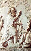
One of the most impressive reliefs inside the largest grotto or ivan is the gigantic equestrian figure of the Sassanid king Khosrau II (591-628 CE) mounted on his favorite charger, Shabdiz. Both horse and rider are arrayed in full battle armor.
The arch rests on two columns that bear delicately carved patterns showing the tree of life or the sacred tree. Above the arch and located on two opposite sides are figures of two winged angles with diadems.
Around the outer layer of the arch, a conspicuous margin has been carved, jagged with flower patterns. These patterns are also found in the official costumes of Sassanid kings.
Equestrian relief panel measured on 16.08.07 approx. 7.45m across by 4.25 m high.
Behistun
| UNESCO World Heritage Site | |
|---|---|
 | |
| Criteria | Cultural: ii, iii |
| Reference | 1222 |
| Inscription | 521 BC (30th Session) |
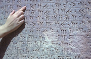
Behistun inscription is considered as a UNESCO World Heritage Site. The Behistun Inscription (also Bisitun or Bisutun, Modern Persian: بیستون ; Old Persian: Bagastana, meaning "the god's place or land") is a multi-lingual inscription located on Mount Behistun.
The inscription includes three versions of the same text, written in three different cuneiform script languages: Old Persian, Elamite, and Babylonian. A British army officer, Henry Rawlinson, had the inscription transcribed in two parts, in 1835 and 1843. Rawlinson was able to translate the Old Persian cuneiform text in 1838, and the Elamite and Babylonian texts were translated by Rawlinson and others after 1843. Babylonian was a later form of Akkadian: both are Semitic languages. In effect, then, the inscription is to cuneiform what the Rosetta Stone is to Egyptian hieroglyphs: the document most crucial in the decipherment of a previously lost script.
The inscription is approximately 15 metres high by 25 metres wide, and 100 metres up a limestone cliff from an ancient road connecting the capitals of Babylonia and Media (Babylon and Ecbatana). It is extremely inaccessible as the mountainside was removed to make the inscription more visible after its completion. The Old Persian text contains 414 lines in five columns; the Elamite text includes 593 lines in eight columns and the Babylonian text is in 112 lines. The inscription was illustrated by a life-sized bas-relief of Darius, holding a bow as a sign of kingship, with his left foot on the chest of a figure lying on his back before him. The prostrate figure is reputed to be the pretender Gaumata. Darius is attended to the left by two servants, and ten one-metre figures stand to the right, with hands tied and rope around their necks, representing conquered peoples. Faravahar floats above, giving his blessing to the king. One figure appears to have been added after the others were completed, as was (oddly enough) Darius' beard [citation needed], which is a separate block of stone attached with iron pins and lead.
Mo'avenalmolk Mosque
This mosque is unique because it has many pictures on the walls that relate to shahnameh,despite some of its more religious ones.
Khaja Barookh's House
Khaja Barookh's House, is a house located in the old district of Faizabad in a Jewish neighborhood of Kermanshah. It was built by Barookh, a Jewish merchant of the Qajar period. The house, importasnt in its Iranian architecture, is now known as Randeh-Kesh house, after the last owner, is a "daroongara"(pro-interior)house and is connected through a vestibule to the exterior yard and through a corridor to the interior yard.[1] Surrounding the interior yard are rooms, brick pillars making the iwans(porches) of the house, and step-like column capitals decorated with brick-stalactite work. This house is among the rare Qajar houses with a private bathroom.
Economy
Kermanshah is one of the western agricultural core of Iran that produces grain, rice, vegetable, fruits, and oilseeds, however Kermanshah is emerging as a fairly important industrial city; there are two industrial centers with more than 256 manufacturing units in the suburb of the city. These industries include petrochemical refinery, textile manufacturing, food processing, carpet making, sugar refining, and the production of electrical equipment and tools. Kermanshah Oil Refining Company (KORC) established in 1932 by British companies, is on of the major industries in the city. After recent changes in Iraq, Kermanshah has become one of the main importing and exporting gates of Iran.
Higher education
- Kermanshah University of Medical Sciences
- Razi University
- Azad University of Kermanshah
- Kermanshah University of Technology
- Payame Noor University
Notable people
- Doris Lessing, writer, 2007 winner of the Nobel Prize in Literature (born in Kermanshah to British parents)
- Shahram Nazeri, vocalist and musician
- Hayedeh, vocalist
- Mahasti, vocalist
- Kayhan Kalhor, musician
- Pouran Derakhshandeh, film director, producer, screen writer
- Karim Sanjabi, Iran's attorney in the oil's national movement, former foreign minister
- Rashid Yasemi, one of the Five-Masters of Persian Literature
- Moeini kermanshahi, songwriter
- Ali Mohammad Afghani, novelist
- Ali Ashraf Darvishian, novelist and writer
- Manoochehr Taherzadeh, musician and singer
- Abolghasem Lahouti, poet
- Sousan, singer
- Hanibal Alkhas, painter
- Alexis Kouros, writer, documentary-maker, director and producer
- Roknoddin Mokhtari, violin player
- Nasser Zarafshan, novelist, translator, and attorney
- Bijan Namdar Zangeneh, former minister
- Ebrahim Azizi, member and spokesman of the Guardian Council
- Mir Jalaleddin Kazzazi, writer
- Al-Dinawari, botanist, historian, geographer, astronomer and mathematician
- Mohammad Ranjbar, former Iran national football team player and coach
- Pari Zangeneh, Vocalist
- Yousof Moradian, actor
- Margaret Packard Aro, writer
- Ahmad Hemmati, Literary and Cultural Translator
Photos of Kermanshah
-

Taq-e Bostan Lake -
![Carving of Khosrow Parviz[fn 1]](//upload.wikimedia.org/wikipedia/commons/thumb/a/a6/Knight-Iran.JPG/122px-Knight-Iran.JPG)
Carving of Khosrow Parviz[fn 1] -
-

-

Ferdowsi Square -
-

-

-

Mount Dalekhani -

-

Ghouri Ghaleh Cave -

Ghouri Ghaleh Cave -
-
![Bisotun Inscription[fn 2]](//upload.wikimedia.org/wikipedia/commons/thumb/0/04/Darius_I_the_Great%27s_inscription.jpg/180px-Darius_I_the_Great%27s_inscription.jpg)
-
Close-Up of Bisotun Inscription -
![Taq-e Bostan Carving [fn 3]](//upload.wikimedia.org/wikipedia/commons/thumb/6/66/Harp-Sassanid.png/180px-Harp-Sassanid.png) Taq-e Bostan Carving [fn 3]
Taq-e Bostan Carving [fn 3] -
![Taq-e Bostan Carving [fn 4]](//upload.wikimedia.org/wikipedia/commons/thumb/6/66/Sassanid-woman.png/180px-Sassanid-woman.png)
Taq-e Bostan Carving [fn 4] -

Mount Parau

![Carving of Khosrow Parviz[fn 1]](/wiki/File:Knight-Iran.JPG)


![Taq-e Bostan Carving [fn 3]](/wiki/File:Harp-Sassanid.png)
![Taq-e Bostan Carving [fn 4]](/wiki/File:Sassanid-woman.png)

Foot Notes
- ^ Khosrow Parviz is standing here. On his left is Ahura Mazda, on his right is Anahita, and below is, Khosrau dressed as a mounted Persian knight riding on his favourite horse, Shabdiz.
- ^ Authored by Darius the Great sometime between his coronation as king of the Persian Empire in the summer of 522 BC and his death in autumn of 486 BC.
- ^ Women playing harp while the king is standing in a boat holding his bow and arrows, from 6th century Sassanid Iran.
- ^ Female musicians accompanying king during hunting. These are identified as unfinished carvings, the figures have been blocked-out but yet to be completed [compare with figure bottom right foreground], as elsewhere on the two hunting panels in the larger iwan.
See also
External links
- Pictures of Inscription and Bas relief of Darius the Great - Free Pictures of IRAN irantooth.com
- Photos from Bisotun Complex - From Online Photo Gallery Of Aryo.ir
- Photos from Taq-e Bostan - From Online Photo Gallery Of Aryo.ir
- Photos from Moavenol Molk Tekieh - From Online Photo Gallery Of Aryo.ir
References
- ^ "Cities in Iran". 2005. Retrieved 2008-04-04.
- ^ Iran Chamber society: Kurds form majority of population of Kermanshah. accessed: March 2010.
- ^ "Most ancient Mid East village discovered in western Iran". 2009. Retrieved 2009-05-23.
- ^ "با 11800 سال قدمت، قديميترين روستاي خاورميانه در كرمانشاه كشف شد". 2009. Retrieved 2009-05-23.
- ^ Dehkhoda: Kermanshah.
- ^ "Weatherbase: Historical Weather for Kermanshah, Iran". Weatherbase. 2007. Retrieved 2008-04-04.
- ^ "Kermanshah Airport Weather Guide". Airport Weather Guide. 2008. Retrieved 2008-04-04.
Kermanshah Province, Iran | ||
|---|---|---|
| Capital |  | |
| Counties and cities | ||
| Sights |
| |
| populated places | ||