
Tropical cyclones in 2023: Difference between revisions
→Global atmospheric and hydrological conditions: Made sure info Tags: Mobile edit Mobile web edit |
→North Atlantic Ocean: Added Frankiln’s RI, Idalia, and Jose Tags: Mobile edit Mobile web edit |
||
| Line 272: | Line 272: | ||
The season began unexpectedly on January 16, when the [[National Hurricane Center]] (NHC) began monitoring a non-tropical low-pressure area located north of [[Bermuda]]. It made landfall on northeastern [[Nova Scotia]] on January 17, before dissipating the next day. Though [[2023 Atlantic hurricane season#Unnamed subtropical storm|the system]] had shown some signs of sub-[[tropical cyclogenesis]] at the time, it was not until after a post-analysis, that the NHC reclassified it as a subtropical storm on May 11, and designated it as the season's first storm. Even so, it was not retroactively given a storm name. The system's formation was the earliest season starter in the basin since [[2016 Atlantic hurricane season|2016]]. |
The season began unexpectedly on January 16, when the [[National Hurricane Center]] (NHC) began monitoring a non-tropical low-pressure area located north of [[Bermuda]]. It made landfall on northeastern [[Nova Scotia]] on January 17, before dissipating the next day. Though [[2023 Atlantic hurricane season#Unnamed subtropical storm|the system]] had shown some signs of sub-[[tropical cyclogenesis]] at the time, it was not until after a post-analysis, that the NHC reclassified it as a subtropical storm on May 11, and designated it as the season's first storm. Even so, it was not retroactively given a storm name. The system's formation was the earliest season starter in the basin since [[2016 Atlantic hurricane season|2016]]. |
||
On June 1, the day of the official start of the season, a [[low-pressure area]] in the [[Gulf of Mexico]] initially expected not to develop further became Tropical Depression Two. It soon intensified into [[Tropical Storm Arlene (2023)|Tropical Storm Arlene]]. On June 3, Arlene weakened to a remnant low. Then, two weeks later, successive [[tropical wave]]s coming off the coast of [[West Africa]] each produced a tropical cyclone. Tropical Depression Three formed on June 19 and intensified into [[Tropical Storm Bret (2023)|Tropical Storm Bret]] that same day. Tropical Depression Four formed on June 22 and intensified into [[Tropical Storm Cindy (2023)|Tropical Storm Cindy]] early the next day. Bret would later reach its peak intensity as a high-end tropical storm before moderate wind shear took its toll on the system. On July 7, a low-pressure area in the open Atlantic was forecast to spawn. Surely enough, a system spawned. The system was not expected to strengthen at first, but its thunderstorms became well organized near the Azores with gale-force winds, and early on Friday, Subtropical storm Don formed. However, deep convection decreased and was downgraded to a subtropical depression as the system started its anticyclonic loop. Afterward, Don transitioned to a tropical depression and then upgraded to a tropical storm. The storm maintained its intensity for a few days until it encountered warmer waters and quickly strengthened to a Category 1 hurricane, the first hurricane of the season. Afterward, the system weakened over cooler waters and turned post-tropical on July 24. Nearly a month later, on August 19, a tropical depression formed over the open Atlantic. It was designated as Gert, as it moved west towards the Carribean. On August 21, Gert dissipated east of the Carribean. The day after Gert formed, two tropical storms formed, those being [[Tropical Storm Emily (2023)|Tropical Storm Emily]] and [[Tropical Storm Franklin (2023)|Hurricane Franklin]]. |
On June 1, the day of the official start of the season, a [[low-pressure area]] in the [[Gulf of Mexico]] initially expected not to develop further became Tropical Depression Two. It soon intensified into [[Tropical Storm Arlene (2023)|Tropical Storm Arlene]]. On June 3, Arlene weakened to a remnant low. Then, two weeks later, successive [[tropical wave]]s coming off the coast of [[West Africa]] each produced a tropical cyclone. Tropical Depression Three formed on June 19 and intensified into [[Tropical Storm Bret (2023)|Tropical Storm Bret]] that same day. Tropical Depression Four formed on June 22 and intensified into [[Tropical Storm Cindy (2023)|Tropical Storm Cindy]] early the next day. Bret would later reach its peak intensity as a high-end tropical storm before moderate wind shear took its toll on the system. On July 7, a low-pressure area in the open Atlantic was forecast to spawn. Surely enough, a system spawned. The system was not expected to strengthen at first, but its thunderstorms became well organized near the Azores with gale-force winds, and early on Friday, Subtropical storm Don formed. However, deep convection decreased and was downgraded to a subtropical depression as the system started its anticyclonic loop. Afterward, Don transitioned to a tropical depression and then upgraded to a tropical storm. The storm maintained its intensity for a few days until it encountered warmer waters and quickly strengthened to a Category 1 hurricane, the first hurricane of the season. Afterward, the system weakened over cooler waters and turned post-tropical on July 24. Nearly a month later, on August 19, a tropical depression formed over the open Atlantic. It was designated as Gert, as it moved west towards the Carribean. On August 21, Gert dissipated east of the Carribean. The day after Gert formed, two tropical storms formed, those being [[Tropical Storm Emily (2023)|Tropical Storm Emily]] and [[Tropical Storm Franklin (2023)|Hurricane Franklin]]. Franklin then made a landfall on Hispanola, and after a few days began 1 day of rapid intensification to a high-end Category 4. It then weakend under high shear associated with Idalia’s outflow and a drop in SST. Then Idalia formed, rapidly intensifying into a minmial Category 4 just before slightly weakening before landfall with more rapid weakening thereafter. Shortly before Idalia made a 125mph landfall on Florida, Tropical Depression 11L suprisingly formed, as the NHC dropped the AOI which eventually became 11L to 0% right before formation! Shortly before Idalia reemerged over water and became extratropical, 11L became Tropical Storm Jose. |
||
{{clear}} |
{{clear}} |
||
Revision as of 23:17, 31 August 2023
This article needs additional citations for verification. (January 2023) |
| Tropical cyclones in 2023 | |
|---|---|
 Year summary map | |
| Year boundaries | |
| First system | 03F |
| Formed | January 5, 2023 |
| Strongest system | |
| Name | Mawar |
| Lowest pressure | 900 mbar (hPa); 26.58 inHg |
| Longest lasting system | |
| Name | Freddy (Longest-lasting tropical system on record) |
| Duration | 37 days |
| Year statistics | |
| Total systems | 71 (+ 2 unofficial) |
| Named systems | 45 (+ 2 unofficial) |
| Total fatalities | 2,147 (10)[a] |
| Total damage | ≥ $27.84 billion (2023 USD) |

Among them, Mawar (center image in the second row) was the most intense with a minimum central pressure of 900 hPa.
In 2023, tropical cyclones formed in seven major bodies of water, commonly known as tropical cyclone basins. Tropical cyclones will be named by various weather agencies when they attain maximum sustained winds of 35 knots (65 km/h; 40 mph). So far, 71 systems formed, with 45 of them being named. The most intense storm of the year so far has been Typhoon Mawar, with a minimum pressure of 900 hPa (26.58 inHg). The current deadliest tropical cyclone of the year is Cyclone Freddy, which killed more than 1,400 people in Malawi, Mozambique, Madagascar, Zimbabwe, and Mauritius, while the costliest tropical cyclone so far is Typhoon Doksuri, which caused at least US$15.4 billion worth of damage. Throughout 2023, nineteen major tropical cyclones have formed, including five Category 5 tropical cyclones in the Saffir–Simpson scale (SSHWS) during the year.
Tropical cyclones are primarily monitored by ten warning centers across the world, designated as a Regional Specialized Meteorological Center (RSMC) or a Tropical Cyclone Warning Center (TCWC) by the World Meteorological Organization (WMO). These ten centers are the National Hurricane Center (NHC), the Central Pacific Hurricane Center (CPHC), the Japan Meteorological Agency (JMA), the Indian Meteorological Department (IMD), Météo-France (MFR), Indonesia's Badan Meteorologi, Klimatologi, dan Geofisika, the Australian Bureau of Meteorology (BoM), Papua New Guinea's National Weather Service, the Fiji Meteorological Service (FMS), and New Zealand's MetService. Other notable warning centers include the Philippine Atmospheric, Geophysical and Astronomical Services Administration (PAGASA; albeit official within the Philippines), the United States' Joint Typhoon Warning Center (JTWC), and the Brazilian Navy Hydrographic Center.
Global atmospheric and hydrological conditions
There is an amplified Madden-Julian Oscillation (MJO) event over the Eastern Indian Ocean present and is contributing to instability and an increase in conductive environment for increased convective activity in the area.[citation needed] On February 9, the NOAA made a new ENSO forecast stating that the La Niña is still ongoing but will transition into an ENSO-Neutral soon. It says that there is around a 5% chance that the La Niña persists throughout March and around a 95% chance of an ENSO-Neutral in March. NOAA Annouced an El Nino later in the year. [1]
Summary

North Atlantic Ocean

The season began unexpectedly on January 16, when the National Hurricane Center (NHC) began monitoring a non-tropical low-pressure area located north of Bermuda. It made landfall on northeastern Nova Scotia on January 17, before dissipating the next day. Though the system had shown some signs of sub-tropical cyclogenesis at the time, it was not until after a post-analysis, that the NHC reclassified it as a subtropical storm on May 11, and designated it as the season's first storm. Even so, it was not retroactively given a storm name. The system's formation was the earliest season starter in the basin since 2016.
On June 1, the day of the official start of the season, a low-pressure area in the Gulf of Mexico initially expected not to develop further became Tropical Depression Two. It soon intensified into Tropical Storm Arlene. On June 3, Arlene weakened to a remnant low. Then, two weeks later, successive tropical waves coming off the coast of West Africa each produced a tropical cyclone. Tropical Depression Three formed on June 19 and intensified into Tropical Storm Bret that same day. Tropical Depression Four formed on June 22 and intensified into Tropical Storm Cindy early the next day. Bret would later reach its peak intensity as a high-end tropical storm before moderate wind shear took its toll on the system. On July 7, a low-pressure area in the open Atlantic was forecast to spawn. Surely enough, a system spawned. The system was not expected to strengthen at first, but its thunderstorms became well organized near the Azores with gale-force winds, and early on Friday, Subtropical storm Don formed. However, deep convection decreased and was downgraded to a subtropical depression as the system started its anticyclonic loop. Afterward, Don transitioned to a tropical depression and then upgraded to a tropical storm. The storm maintained its intensity for a few days until it encountered warmer waters and quickly strengthened to a Category 1 hurricane, the first hurricane of the season. Afterward, the system weakened over cooler waters and turned post-tropical on July 24. Nearly a month later, on August 19, a tropical depression formed over the open Atlantic. It was designated as Gert, as it moved west towards the Carribean. On August 21, Gert dissipated east of the Carribean. The day after Gert formed, two tropical storms formed, those being Tropical Storm Emily and Hurricane Franklin. Franklin then made a landfall on Hispanola, and after a few days began 1 day of rapid intensification to a high-end Category 4. It then weakend under high shear associated with Idalia’s outflow and a drop in SST. Then Idalia formed, rapidly intensifying into a minmial Category 4 just before slightly weakening before landfall with more rapid weakening thereafter. Shortly before Idalia made a 125mph landfall on Florida, Tropical Depression 11L suprisingly formed, as the NHC dropped the AOI which eventually became 11L to 0% right before formation! Shortly before Idalia reemerged over water and became extratropical, 11L became Tropical Storm Jose.
Eastern & Central Pacific Oceans

The 2023 Pacific hurricane season had the second-latest forming first named storm on record in the eastern Pacific (since 1970), behind only Tropical Storm Agatha in 2016. The first storm of the season, Adrian formed on June 27, followed by Beatriz which impacted the southwestern coast of Mexico on June 29. Fortunately, Adrian stayed out to sea and became a category 2 hurricane with winds of 110 mph (175 km/h). On July 11, Tropical Depression Three-E formed and was later named Calvin. Since the system encountered favorable conditions, Calvin rapidly intensified to a high-end Category 3 hurricane, becoming the first major hurricane of the season. Afterward, Calvin weakened to a tropical storm as it headed west and passed south of the Big Island, Hawaii, before dissipating. Later in July, Tropical Depression Four-E formed in a marginally favorable environment, but it was short-lived due to increasing wind shear. On July 28, a tropical wave entered the Pacific Ocean and developed into Dora on July 31. On August 3, Dora became a Category 4 hurricane and fluctuated between Category 3 and Category 4 until August 12, when it weakened into a Category 2, and crossed the International Date Line, leaving the Eastern Pacific. Meanwhile, on August , a tropical wave intensified into Tropical Storm Eugene, which moved northwest away from Mexico. A few days after Eugene dissipated, Tropical Storm Fernanda formed and moved west, peaking as a Category 4. It dissipated on August 17, along with Tropical Storm Greg, which formed 2 days after Fernanda. The day before Fernanda and Greg dissipated, Tropical Storm Hilary formed and moved northwest, curving further north and making landfall on Baja California, moving north into the United States, causing record flooding for California.
Western Pacific Ocean

The season began on March 4 with the formation of a tropical depression which formed near the equator, east of Singapore. The depression was short lived and was last noted three days later. The storm however, brought heavy rainfall across Malaysia, affecting about 50,000 people.
A month later on April 7, the JMA began tracking a low-pressure area located in the Philippines Sea. On the same day the JMA classified the system as a tropical depression with the PAGASA naming the system Amang. The depression made three landfalls in the Philippines before weakening into a remnant low on April 13. Amang caused minor damage across the country however, no fatalities were reported. Five days after Amang dissipated, the JMA began monitoring another disturbance located near Pohnpei. After slowly intensifying, the system reached tropical storm status and the system was named Sanvu by the JMA; becoming the first named storm in the basin. Sanvu however began to weaken after entering hostile environment. The storm weakened back into a tropical depression until it dissipated on April 25.

On May 5, a tropical depression was noted in the Sulu Sea by the JMA. The system crossed Palawan and entered the West Philippine Sea on the same day. The system continued to traverse the South China Sea before dissipating on May 7. On May 19, a tropical depression developed south-southwest of the Chuuk Islands. A few hours later, it became a tropical storm and was named Mawar. On the next day, the JMA upgraded the system into a Severe Tropical Storm, as the storm was getting better defined. A day later, Mawar was classified as a Category-1 equivalent typhoon by the JTWC. The JMA followed suit and designated the system as a Typhoon on the same day; becoming the first typhoon of the year in the basin. Mawar later strengthened into a Category 2-equivalent typhoon on May 22. Then, the storm began to explosively intensify and reached Category 3-equivalent status on the same day. It further strengthened into a Category 4-equivalent super typhoon on the next day as it approached Guam. Land interaction with Guam and an eyewall replacement cycle caused the storm to weaken slightly but eventually restrengthened after passing the northern tip of Guam on May 24. The next day, Mawar completed its eyewall replacement cycle and went on to reach its peak intensity of 295 km/h (185 mph), equivalent to a very strong Category 5-equivalent super typhoon. As Mawar entered the PAR which was named Betty by PAGASA, it encountered cooler oceans and increasing wind shear which caused it to weaken. It also underwent yet another eyewall replacement cycle causing the storm to weaken further. It affected the eastern coast of Luzon and weakened to a severe tropical storm as it left the PAR on June 1. It affected the Okinawa Islands and finally turned extratropical south of Honshu on June 3.
On June 5, a low-pressure area was formed north of Palau, naming the system as Invest 98W. At the following day, it intensified and entered the Philippine area of responsibility, prompting to name the PAGASA as Chedeng at 08:00 UTC. The JTWC later followed suit and designated it as 03W. At 20:00 UTC, Chedeng was upgraded into a tropical storm, attaining the name Guchol. Guchol later became a strong Category 2 typhoon in the Philippine Sea, but the cold wake from Super Typhoon Mawar kept it from intensifying any further. As Guchol (Chedeng) exited the PAR, it weakened into a severe tropical storm, and continued northeastwards, avoiding the Japanese archipelago.
On July 13, A monsoon depression formed near Luzon. PAGASA noted the system and subsequently named the system Dodong. The system then crossed the island. The system then entered the South China Sea, where it became a tropical depression. Later, it became a tropical storm. It was named Talim. Talim moved through the South China Sea as it intensified. Near the coast of China, Talim reached its peak intensity as a category 2-equivalent typhoon. Talim slightly weakened before making landfall in China at 22:20 CST. About six hours later, Talim entered the Gulf of Tonkin and made a second landfall. On July 18, Talim dissipated inland.
On July 19, the JMA began tracking a disturbance in the Philippine Sea. On July 21, the JMA noticed it had begun to become more organized and it was upgraded into a tropical storm, with the name given being Doksuri. The PAGASA also noted the formation and gave it the name Egay. On July 23, the system began to rapidly intensify, and achieved typhoon status. Late on July 24, the JMA classified it as a Super Typhoon. The next morning the PAGASA did the same thing as on that day it reached its peak of 1 minute sustained winds of 150 mph. Doksuri began to slow as it reached the northern Philippines. With dry air in the area, Doksuri began to undergo an eyewall replacement cycle. It eventually began to deintensify following the eyewall replacement. However, as it exited the region on July 27, it began to reintensify. It was now heading toward Taiwan and China with 1 minute sustained winds of 120 mph. On July 28, it made its last landfall in China; however, it rapidly began to weaken. On July 29, Doksuri dissipated inland over China.
North Indian Ocean

The season began on January 30 with the formation of a tropical depression classified as BOB 01 over the Bay of Bengal. The storm's formation makes it the first time since 2019 to see a storm develop in the month of January in the basin. The JTWC later issued a TCFA on the system, which it designated as Invest 90B. It weakened after continued land interaction with Sri Lanka.
After almost four months of inactivity, the IMD began to monitor a disturbance which was located in the Bay of Bengal on May 6. The system steadily improved and was upgraded into a Depression by the IMD, classified as BOB 02. Soon afterward on May 10, it intensified to a Deep Depression. On the next day, it strengthened into a Cyclonic Storm; with the IMD assigning the name Mocha. Mocha afterward, began to intensify rapidly and reached its peak intensity as a Category 5-equivalent cyclone on May 14. Mocha then made landfall just north of Sittwe, Myanmar as a Category 4-equivalent cyclone. The cyclone then rapidly weakened and was last noted over the Chinese province of Yunnan on May 15. Mocha caused heavy damage across Myanmar and Bangladesh and killed at least 400 people. On June 1, the IMD monitored a disturbance in the Arabian Sea and was later upgraded to a cyclonic storm on June 6, receiving the name Biparjoy. The system quickly intensified to Category 1-equivalent strength, but afterward moderate easterly wind shear limited Biparjoy's intensification for a while. However, the cyclone unexpectedly rapidly intensified and reached its peak as a Category 3 cyclone. Afterward, wind shear began to take a toll on Biparjoy and made landfall near Naliya, India. The brown ocean effect caused the cyclone to gradually weaken and was finally downgraded to a well-marked low-pressure area by the IMD on June 19. Meanwhile, in the Bay of Bengal, a low-pressure area formed on June 9, and the JTWC designated it Tropical Cyclone 03B with sheared yet organized convection. On June 10, the system weakened to a low-pressure area over Bangladesh and dissipated.
South-West Indian Ocean
January - June

On January 17, a zone of Disturbed Weather classified as 05 formed northeast of Madagascar. It was later upgraded to Tropical Depression by the MFR and the JTWC. Meteo Madagascar later named it Cheneso. After making landfall in northeastern Madagascar, the JTWC issued their final warning. The MFR, however, was still tracking the system, and stated that Cheneso had become an overland depression. On January 21, the JTWC began re-issuing advisories, as the system had re-emerged over water, and later re-issued a TCFA on the system. The MFR re-designated the system as Tropical Disturbance Cheneso. The JTWC re-upgraded the system to tropical storm status, and on January 24, the MFR, upgraded it to a moderate tropical storm. It was later upgraded to tropical cyclone (MFR designation) and category-1 hurricane (JTWC designation). With land interaction and upwelling cool waters, it degenerated into a severe tropical storm (MFR designation) on January 27 as it started accelerating towards the south. It was later downgraded to tropical storm by the JTWC. After briefly re-intensifying to tropical cyclone status, it was downgraded to strong tropical storm and transitioned into a Post-tropical depression on January 29. By January 30, JTWC issued the last warning for Cheneso.

On February 9, Tropical Low 11U from the Australian region moved into the Southwest Indian Ocean basin, which the MFR classified as Moderate Tropical Storm Dingani. The JTWC initiated advisories as Tropical Cyclone 13S. It was struggling to intensify due to high wind shear, however was later upgraded to Severe Tropical Storm. It was later upgraded to Tropical Cyclone status by the MFR and Category 1 Hurricane by the JTWC. After reaching Category 2 status, it turned southward, and after weakening, it transitioned into a post-tropical depression on February 15. On February 14, Severe Tropical Cyclone Freddy entered this basin, where it was immediately designated as a Tropical Cyclone by the MFR. It later intensified into Intense Tropical Cyclone on the MFR's scale, and re-intensified into a Category 5 major hurricane on the SSHWS, becoming the first category 5 cyclone of the year. After weakening, it later re-intensified, reaching Very Intense Tropical Cyclone status on the MFR's scale. On February 21, it weakened and made landfall in Madagascar, and emerged into the Mozambique Channel. It re-intensified to Severe Tropical Storm status and February 24, made its second landfall in Mozambique. On February 22, a Tropical Depression formed, which later intensified into a Moderate Tropical Storm, hence gaining the name Enala. The system eventually intensified to Tropical Cyclone status before steadily weakening as it was heading southwards. Freddy, meanwhile, re-emerged into the Mozambique Channel on March 2, where it eventually intensified to Tropical Cyclone status. On March 11, the system made landfall in Mozambique for the final time, dissipating inland on March 14. On 21 March, a weak low-pressure developed over the central Indian Ocean, MFR initially estimated a "very low" chance of a moderate tropical storm. On March 25, it intensified into a tropical depression, dissipating on March 28.

On May 13, a disturbance was noted by the MFR as it developed across the Indian Ocean. Soon afterwards, it strengthened into a tropical disturbance. The JTWC later issued the TCFA on the system which not long after, the MFR designated the system as Tropical Depression 10. The next day, it intensified into a Moderate Tropical Storm with the name Fabien. Fabien then intensified to an Intense Tropical Cyclone on May 16, becoming the latest major cyclone on record, suppressing Cyclone Billy-Lila of 1986 by 6 days[2] The MFR and JTWC later downgraded Fabien to a remnant low on May 22.
July - December
Australian Region
January - June

The season began with Cyclone Ellie, which persisted into 2023. Ellie dissipated on January 8, ending its long duration over the Australian mainland. On January 6, Tropical Low 07U formed over the Coral Sea, becoming the first storm to form in the basin. 07U entered the South Pacific basin on the next day, where it was named Hale by the FMS. Tropical Disturbance 05F formed on January 14 by the FMS, while it was still in the Australian basin. It briefly moved into the South Pacific basin and re-entered into the Australian basin. It later moved back into the South Pacific Basin. On January 18, a tropical low formed. The JTWC issued a TCFA on the system as it crossed into the South Pacific basin. It was later identified as 06F (10P from JTWC) and was dissipated on January 21 with vertical wind shear in South Pacific Ocean. On January 22, a tropical low classified as 10U by the BoM formed from a monsoon trough over the Arafura Sea, which generally headed westward after formation. It dissipated on January 26. On January 27, the BoM noted that a tropical low formed in the central Indian Ocean and classified it as 11U. The JTWC designated the system as Invest 94S, and began to consolidate. Another tropical low formed in the central Indian Ocean being classified as 12U by the BoM and Invest 95S by the JTWC, which dissipated on February 5.

The same day, another tropical low classified as 13U by the BoM and 97S by the JTWC formed northeast of 12U, and began to consolidate. 13U intensified into a Category 1 tropical cyclone, henceforth being assigned the name Freddy. Tropical Low 14U formed south of the Solomon Islands, also being tracked by the JTWC, by the code identifier 99P. Freddy intensified into a Category 3 on the Australian scale, and 14U became the fifth named storm of 2023 as it became a Category 1 on the Australian scale, henceforth being assigned the name Gabrielle. Tropical Low 11U moved into the Southwest Indian Ocean basin on February 9, where it was assigned the name Dingani. Freddy weakened into a category two tropical cyclone before intensifying again. Gabrielle moved into the South Pacific basin as a Category 3 severe tropical cyclone on February 10. Freddy intensified into a Category 4 on both the Australian scale and the SSHWS. Tropical Low 15U formed in the Gulf of Carpentaria on February 11. Freddy, after weakening slightly, moved into the South-west Indian Ocean basin on February 14. 15U was last noted on February 17. On February 23, the BoM reported that 16U had formed to the north of the coast of Pilbara, later moving into the Gulf of Carpentaria before moving inland. 17U, a weak tropical low, formed over land to the south of the Joseph Bonaparte Gulf on February 24. Another weak tropical low formed on February 26, classified as 18U by the BoM. 18U moved into the South Pacific basin on March 1. 17U, meanwhile, was last noted on February 27.
On March 28, Tropical Low 21U formed near the coast of Cocos Kelling Islands, a day later it intensified giving it the name Herman, a few days later it intensified into a Category 5 severe tropical cyclone. However, it started to rapidly deteriorate down to a tropical low within 48 hours after its peak. A week later on April 6, the BoM noted a tropical low forming in the Timor Sea. It gradually intensified as it moved southwest before being designated Topical Low 23U. The storm rapidly improved and was upgraded to a Category 1 tropical cyclone by the BoM, naming the system Ilsa. Ilsa went along the coast of Western Australia while steadily intensifying to a Category 3 severe tropical cyclone on April 12. Ilsa gradually tracked southwest before turning to the southeast where it further intensified to a Category 5 severe tropical cyclone. One minute sustained winds of 260 km/h (160 mph) was recorded by the JTWC, making the system equivalent to a Category 5 equivalent cyclone on the SSHWS. The BoM also monitored record breaking ten-minute sustained winds of 218 km/h (135 mph) in Bedout Island beating the previous record of Cyclone George in 2007. In the late hours of April 13, Ilsa made landfall east of Port Hedland. Ilsa rapidly weakened while inland prompting the JTWC to cease its advisories on the system. Ilsa further degenerated into a low and dissipated on April 16. On April 30, the BoM noted a weak tropical low south of Christmas Island.
July - December
South Pacific Ocean
January - June

On January 5, a tropical disturbance which was designated as 03F formed near New Caledonia, becoming the first system to form in 2023. 03F dissipated two days later as it was in close proximity with nearby Cyclone Hale. On January 7, Tropical Low 07U entered the basin from the Australian region, where it was reclassified as 04F. On the same day, the system strengthened into a Category 1 cyclone and was named Hale by the FMS. Hale struggled to intensify further due to moderate wind shear and became an extratropical cyclone as it approached New Zealand. Hale caused widespread flooding and slips in the northern and eastern parts of the country however, no fatalities were reported. Tropical Disturbance 05F formed on January 14 by the FMS, while it was still in the Australian basin. It briefly moved into the South Pacific basin and re-entered into the Australian basin. It later moved back into the South Pacific basin. After re-entering into the basin, the JTWC had upgraded the system to Cyclone 09P, and the FMS named the system Irene, as the system had reached tropical storm intensity. It began subtropical transition and completed it on January 19, in which the JTWC issued their final warning on the system. The tropical low that had formed in the Australian region on January 18 crossed over into the South Pacific basin, where the JTWC kept up its TCFA on the system. The FMS classified the system as Tropical Depression 06F. The system dissipated on January 22 without any impacts to land.
Severe Tropical Cyclone Gabrielle moved into the South Pacific basin on February 10. It reached peak intensity in this basin as a Category 3 on the Australian scale, and later made landfall on Norfolk Island as a Category 2, and subsequently became subtropical, prompting the BoM and the JTWC to cease advisories, however the JTWC was still tracking it as Subtropical Storm 12P. However, it eventually became fully extratropical and the JTWC stopped tracking the system. Tropical Disturbance 08F formed just south of Samoa on February 23. It later intensified into a Category 1 Tropical Cyclone, hence being assigned the name Judy. It later intensified into a Category 4 severe Tropical Cyclone. On March 5 it weakened into an Extatropical Cyclone. On February 27 the Bureau of Meteorology (BoM) had started tracking Tropical Low 18U on the Australian Region then it entered the South Pacific Basin where it intensified into a Category 1 Tropical Cyclone given the name Kevin. It rapidly intensified into a Category 5 Tropical Cyclone just south-east of Vanuatu. It weakened to an extratropical cyclone on March 5. Both Judy and Kevin were major tropical cyclones when they struck Vanuatu only 48 hours apart from each other. Tropical Disturbance 10F formed on March 9 near Niue. On March 11, 11F formed to the west of Tonga, with 12F forming a bit after to the northeast of Vanuatu. Neither of the three systems developed further, with the three dissipating on March 13, 23, and 21, respectively. On March 15, a weak tropical low from the Australian Region moved into the South Pacific Basin, being designated as Tropical Disturbance 13F. However, it did not develop further and became extratropical on April 18.
On March 7, SENAMHI reported an "unorganized tropical cyclone" in the Peruvian Sea.[3] They dubbed the unofficial system as Cyclone Yaku. It dissipated on March 20. The system destroyed thousands of homes in Peru and killed eight people.
July - December
South Atlantic Ocean
On 7 January, a subtropical depression formed about 500 km (310 mi) southeast of Rio de Janeiro.[4] Without affecting any area and moving away from the Brazilian coast, it lost its subtropical characteristics in the afternoon of 10 January, according to the Brazilian Navy Hydrography Center.[5]
Mediterranean Sea
One system formed in the Mediterranean Sea in early 2023. On January 21, Storm Hannelore transitioned into a Mediterranean tropical-like cyclone in the Adriatic Sea. The storm travelled west-northwest and made landfall in the Rimini Province, Italy early on January 22. Hannelore transitioned into an extratropical cyclone soon after landfall and no impacts from the system was reported.[6]
Systems
January

January was active but not intense, featuring twelve systems with five of them being named. From 2022, Cyclone Ellie from the Australian region persisted into 2023. The first storm of the year started off with a short lived disturbance classified as 03F, which formed in the South Pacific basin. Shortly after 03F, a tropical low classified as 07U formed in the Australian basin and later entered the South Pacific basin. There, 07U strengthened into a tropical cyclone and was named Hale by the FMS; becoming the first named storm of the year. The northern part of New Zealand suffered minor flooding after Hale's remnants made landfall over the country on January 10, and one indirect fatality was reported. Four days later, Irene formed, becoming the second named storm in the basin. Irene passed near New Caledonia and Vanuatu however, no serious damage was reported. Moreover, in the Australian and South Pacific basins, four tropical lows classified as 06F, 10U, 11U, and 12U formed. The remnants of 06F contributed to major flooding in New Zealand which caused 4 fatalities. In the South-West Indian Ocean basin, Cyclone Cheneso formed south of Diego Garcia and made landfall over northern Madagascar. After landfall, Cheneso's remnants reorganized in the Mozambique Channel and intensified into a Category 2 cyclone, becoming the strongest storm of the month. Cheneso devastated much of the country and destroyed many infrastructures due to its slow movement off the coast while reorganizing. As of January 31, 33 fatalities were reported from the cyclone. In the Atlantic, a non-tropical low developed over the Gulf Stream in mid-January. During its routine post-operational review, the NHC concluded that from January 16 to 17, the system had been a subtropical storm. Retroactively designated as the first storm of the season, though not given a name, the storm made landfall on the far northeastern coast of Nova Scotia just before it became a post-tropical low, which later dissipated over far eastern Quebec. The Northern Indian Ocean basin also had an early start with a depression classified as BOB 01 forming on January 30. In the South Atlantic, a subtropical depression formed off the coast of Brazil. The depression however, moved away from the coast and weakened. 11U moved into the Southwest Indian Ocean basin on February 9, where it was assigned the name Dingani. It later intensified to Tropical Cyclone on the MFR's scale and Category 1 on the SSHWS. It eventually intensified to Tropical Cyclone status before turning southward and eventually transitioning into a post-tropical depression. The Mediterranean Sea featured Cyclone Hannelore, a short-lived system in the Adriatic Sea.
| Storm name | Dates active | Max wind km/h (mph) |
Pressure (hPa) |
Areas affected | Damage (USD) |
Deaths | Refs |
|---|---|---|---|---|---|---|---|
| 03F | January 5–7 | Unknown | 1000 | New Caledonia | None | None | |
| Hale | January 6–8 | 75 (45) | 994 | New Caledonia, New Zealand | Unknown | 0 (1)[a] | [7] |
| SD | January 7–10 | 55 (35) | 1010 | Rio de Janeiro | None | None | |
| Irene | January 14–20 | 100 (65) | 985 | New Caledonia, Vanuatu | Unknown | None | |
| Cheneso | January 16–29 | 140 (85) | 965 | Madagascar | Unknown | 33 | [8] |
| Unnamed | January 16–17 | 110 (70) | 976 | Nova Scotia | None | None | [9] |
| 06F | January 18–22 | 55 (35) | 996 | New Caledonia, New Zealand | $625 million | 4 | [10] |
| Hannelore | January 21–22 | Unknown | 995 | Italy | None | None | [11] |
| 10U | January 22–26 | Unknown | 1001 | Northern Territory | None | None | |
| Dingani | January 27 – February 15 | 140 (85) | 971 | None | None | None | |
| BOB 01 | January 30 – February 2 | 45 (30) | 1004 | Sri Lanka | None | None | |
| 12U | January 31 – February 4 | Unknown | 1002 | None | None | None |
February


February was active, featuring eleven systems with seven of them being named. The month also includes an unofficial cyclones named Helios and Juliette which both formed in the Mediterranean Sea. The month started off with Freddy, which formed in the Australian Region on February 4. Freddy reached its peak intensity as a Category 4-equivalent cyclone before crossing into the South-West Indian Ocean basin. There, the MFR immediately classified Freddy as an intense tropical cyclone. The cyclone further intensified into a Category 5-equivalent tropical cyclone, becoming the first one of the year. Freddy continued travelling across the Indian Ocean before making landfall over Madagascar and Mozambique, killing at least 100 people. Unexpectedly, Freddy emerged back over the Mozambique Channel and restrengthed back into a cyclone. The cyclone then made its second landfall over Mozambique and dissipated on March 14; ending its erratic five week lifespan. Freddy left severe destruction across its path and killed at least 1,400 people. Freddy also became the longest-lived tropical cyclone on record and was also the first cyclone since Leon–Eline and Hudah in 2000 to travel across the entire Southern Indian Ocean. On February 6, Cyclone Gabrielle formed in the Australian Region. As Gabrielle headed towards New Zealand, the cyclone reached its peak intensity as a Category 3 cyclone. Gabrielle caused extensive damage across New Zealand and other nearby countries. Gabrielle became the costliest tropical cyclone on record in the Southern Hemisphere. Additionally, the cyclone was the deadliest in New Zealand since 1968. Cyclone Enala formed on February 19 in the Southern Indian Ocean and reached its peak as a Category 1-equivalent cyclone. However, Enala had no effect on land. Judy and Kevin both formed in the South Pacific basin and intensified into major cyclones. The two cyclones later impacted Vanuatu. Four other weak tropical lows also formed in the Australian Region. Most were short lived and were no threat to land. Additionally, Cyclone Helios and Juliette in the Mediterranean Sea brought record-breaking rainfall on Malta and heavy snow and large waves occurred in the parts of Italy, Spain and France..
| Storm name | Dates active | Max wind km/h (mph) |
Pressure (hPa) |
Areas affected | Damage (USD) |
Deaths | Refs |
|---|---|---|---|---|---|---|---|
| Freddy | February 5 – March 14 | 220 (140) | 931 | Mascarene Islands, Madagascar, Mozambique, Zimbabwe, Malawi | Unknown | 1,434 | [12][13][14][15][16] |
| Gabrielle | February 6–11 | 150 (90) | 958 | Norfolk Island, New Zealand | $8.12 billion | 11 (1) | [17][18] |
| Helios | February 10–11 | Unknown | Unknown | Malta, Sicily, Tunisia | Unknown | None | [19] |
| 15U | February 11–17 | 45 (30) | 997 | None | None | None | [20] |
| TL | February 17–18 | Unknown | 1004 | None | None | None | |
| Enala | February 21–28 | 120 (75) | 980 | None | None | None | |
| Judy | February 23–March 4 | 185 (115) | 940 | Vanuatu | Unknown | None | |
| 16U | February 23–March 10 | Unknown | 995 | Western Australia, Northern Territory | None | None | |
| 17U | February 24–27 | Unknown | 999 | Northern Territory | None | None | |
| Juliette | February 27-March 4 | Unknown | Unknown | Italy, Spain, France | None | None | [21] |
| Kevin | February 27–March 5 | 230 (145) | 913 | Solomon Islands, Vanuatu | Unknown | None |
March

March was inactive, especially in terms of named storms, featuring nine systems with only two of them being named. The month also includes an unofficial cyclone named Yaku which formed off the coast of Peru and Ecuador. In the Northern Pacific basin, a tropical depression formed on March 4 east of Singapore near the equator, becoming the first storm of the year to form in the basin. The depression dissipated the next day. However, the storm killed four people after flooding parts of Malaysia. In the South Pacific basin, three tropical lows classified as 10F, 11F, and 12F formed and dissipated without causing serious damage. In the Australian basin, three systems formed with Herman being the strongest storm of the month. Herman formed on March 29 and headed towards the Australian coast and later reached its peak intensity as a Category 5 severe tropical cyclone on the Australian scale. The cyclone however turned around and weakened due to dry air. Herman was last noted on April 5 by the JTWC. In the Southern Indian Ocean basin, a short lived depression classified as 09 formed on March 25 and dissipated two days later without affecting any landmass. Yaku, being an unofficial storm of the South Pacific basin unusually formed in the Southeastern Pacific near South America. The cyclone killed at least eight people and caused serious damage across Peru and Ecuador.
| Storm name | Dates active | Max wind km/h (mph) |
Pressure (hPa) |
Areas affected | Damage (USD) |
Deaths | Refs |
|---|---|---|---|---|---|---|---|
| TD | March 4–7 | 55 (35) | 1008 | Brunei, Indonesia, Malaysia, Singapore | Unknown | 4 | [22] |
| Yaku | March 7–20 | Unknown | 1009 | Peru, Ecuador | None | ≥8 | [23] |
| 10F | March 8–13 | Unknown | 1006 | Niue | None | None | |
| 11F | March 11–23 | Unknown | 1006 | Tonga, Niue | None | None | |
| 12F | March 11–21 | Unknown | 1005 | New Caledonia | None | None | |
| 20U | March 25–31 | Unknown | 1005 | None | None | None | |
| 09 | March 25–28 | 75 (45) | 997 | None | None | None | |
| Herman | March 28–April 3 | 215 (130) | 930 | Cocos Islands | None | None | |
| 22U | March 30–April 2 | Unknown | Unknown | None | None | None |
April

April was a very inactive month, featuring only five systems with two[nb 1] of them being named. The month started off with a disturbance forming in the Australian Region on April 5. The disturbance, which was classified as 23U was later named Ilsa by the BoM on April 10. Ilsa continued on and reached its peak intensity as a Category 5 cyclone on both the Australian scale and the SSHWS as it neared the Australian coast, becoming the strongest storm of the month. The cyclone made landfall east of Port Hedland and weakened before it was last noted on April 16. In the Western Pacific basin, the JMA noted a low pressure area forming in the Philippine Sea on April 7. The low was later classified as a tropical depression after its structure slightly improved. As it entered the PAR, the depression was named Amang by the PAGASA. Amang made three landfalls in Southern Luzon before weakening into a remnant low on April 3 due to dry air and wind shear. A week later, a tropical depression formed near Pohnpei. The depression later intensified into a tropical storm, where it was named Sanvu by the JMA, becoming the first named storm in the basin. Sanvu however, failed to intensify further due to its poor structure and dissipated on April 25. In the South Pacific basin, a disturbance classified as 13F formed and entered the basin from the Australian basin. The disturbance however was poorly organized and never intensified further. On April 30, a weak tropical low, to the south of Christmas Island, was noted by the BoM.
| Storm name | Dates active | Max wind km/h (mph) |
Pressure (hPa) |
Areas affected | Damage (USD) |
Deaths | Refs |
|---|---|---|---|---|---|---|---|
| Ilsa | April 5–16 | 230 (145) | 915 | Maluku, Lesser Sunda Islands, Northern Territory, Western Australia | >$4 million | 8 | [24] |
| Amang | April 10–13 | 55 (35) | 1004 | Palau, Philippines | $923,000 | None | [25] |
| 13F | April 14–18 | Unknown | 999 | None | None | None | |
| Sanvu | April 19–22 | 85 (50) | 996 | Federated States of Micronesia | None | None | |
| TL | April 30–May 2 | Unknown | Unknown | Christmas Island | None | None |
May

May was a slightly inactive month in terms of named storms, featuring four systems with three of them being named. However, the number of intense tropical cyclones and the ACE were both far above normal. The month started off with a tropical depression, which formed in the Sulu Sea. The system crossed Palawan and entered the West Philippine Sea on May 5 before dissipating two days later. Moreover, in the West Pacific basin, a tropical depression formed near the Chuuk Islands on May 19. On the next day, the JMA named the depression Mawar. Mawar continued intensifying before intensifying into a Category 1-equivalent typhoon, becoming the first typhoon to form in the basin. It later intensified into a Category 5-equivalent typhoon after striking Guam, becoming the strongest storm of the month and currently worldwide. In the Northern Indian Ocean basin, the IMD began monitoring a tropical depression which formed in the Bay of Bengal on May 9. The system was later named Mocha by the IMD after intensifying into a tropical storm. Mocha continued strengthening further; eventually becoming a Category 5-equivalent tropical cyclone on the SSHWS scale. On May 14, the cyclone made landfall on Myanmar and rapidly weakened before it was last noted over China on the next day. Mocha caused heavy damage across Myanmar and Bangladesh and killed at least 400 people. In the South-West Indian Ocean basin, a disturbance formed close to the equator on May 12, east of Indonesia and to the south of strengthening Cyclone Mocha. The MFR later named the system Fabien after reaching tropical storm status. Fabien reached its peak intensity as a Category 3-equivalent cyclone on May 15, becoming the latest tropical cyclone of that intensity, surpassing Cyclone Billy-Lila of 1986 by 6 days. Fabien started to weaken on the next day due to wind shear and dry air. The cyclone degenerated into a remnant low and was last noted on May 21.
| Storm name | Dates active | Max wind km/h (mph) |
Pressure (hPa) |
Areas affected | Damage (USD) |
Deaths | Refs |
|---|---|---|---|---|---|---|---|
| TD | May 5–7 | Unknown | 1004 | Philippines | None | None | |
| Mocha | May 9–15 | 215 (130) | 938 | Andaman and Nicobar Islands, Myanmar, Bangladesh, India, Yunnan | $1.5 billion | 463 | [26][27][28] |
| Fabien | May 12–21 | 175 (110) | 958 | Diego Garcia | None | 16 | [29][30] |
| Mawar (Betty) | May 19–June 3 | 215 (130) | 900 | Federated States of Micronesia, Guam, Northern Mariana Islands, Philippines, Taiwan, Japan, Russian Far East, Alaska | $136 million | 6 | [31][32][33] |
June

June was active, featuring nine systems with seven of them being named. An area of interest formed in the Gulf Of Mexico on May 31. The disturbance quickly became better organized and at 21:00 UTC on June 1, the system was designated as Tropical Depression Two. A day later, the system strengthened into a tropical storm, and named Arlene. On June 6, two tropical depressions formed in the Arabian Sea and in the Philippine Sea. The depression in the Philippine Sea later strengthened into Tropical Storm Guchol at 20:00 UTC. And in the Arabian Sea, the depression rapidly intensified into a category 3 cyclone, which received the name Biparjoy. Later, on June 19, a tropical depression formed in the Atlantic, later receiving the name Bret when it attained tropical storm strength. Another tropical depression developed just a few days later, on June 22, receiving the name Cindy early the next day after being upgraded to a tropical storm. On June 25, in the Eastern Pacific, a depression formed near the coast of Mexico, which upon strengthening into a tropical storm three days later, was named Adrian. This system rapidly strengthen into a category 2 hurricane. Another area of low pressure formed near the southwest coast of Costa Rica on June 25. A few days later, the system organized as a tropical storm, assigned the name as Beatriz.
| Storm name | Dates active | Max wind km/h (mph) |
Pressure (hPa) |
Areas affected | Damage (USD) |
Deaths | Refs |
|---|---|---|---|---|---|---|---|
| Arlene | June 1–3 | 65 (40) | 998 | Florida | None | None | |
| Guchol (Chedeng) | June 5–12 | 140 (85) | 970 | None | None | None | |
| Biparjoy | June 6–19 | 165 (105) | 958 | Western India, Pakistan | $124 million | 17 | [citation needed] |
| TD | June 7–11 | Unknown | 1000 | South China, Vietnam | None | None | |
| 03B | June 9–10 | 75 (45) | 991 | Bangladesh, Myanmar | None | None | |
| Bret | June 19–24 | 110 (70) | 996 | Barbados, Windward Islands, Leeward Antilles, Venezuela, Northerneastern Colombia | Minimal | None | |
| Cindy | June 22–26 | 95 (60) | 1004 | None | None | None | |
| Adrian | June 27–July 2 | 175 (110) | 970 | None | None | None | |
| Beatriz | June 29–July 1 | 140 (85) | 991 | Southwestern Mexico | Unknown | 1 | [citation needed] |
July

July was average, featuring eight systems forming with six of them being named. The month started off with Hurricane Calvin, which formed in the off the coast of Southern Mexico on July 11. The disturbance became well organized several days later which designated the system as Tropical Depression Three-E. The next day, it strengthened and named Calvin. It then started to rapidly intensify and became the first major hurricane at 15:00 UTC on July 14. In the Western Pacific, after several weeks of inactivity, on July 12, a tropical depression formed off the coast of Aurora, Philippines. It made landfall in Dinapigue, Isabela on the next day. Prior exiting the PAR, JMA gained the name Talim as it was upgraded into a tropical storm. In the Atlantic Ocean, a trough of low-pressure was formed east-northeast of Bermuda. A well-defined center of circulation developed along with persistent deep convection early on July 14, prompting the NHC to classify it as Subtropical Storm Don early that morning. After weakening to a depression, Don became fully tropical and strengthened to the first hurricane of the season. Another low pressure formed east of Mindanao on July 19. 2 days later, JMA named the system as Doksuri. Doksuri further intensified and peaked as a Category 4-equivalent super typhoon late on July 24. Shortly after Typhoon Doksuri reached its peak, a new depression formed to its east. On July 27, it received the name Khanun from the JMA, and on July 29, it got the name Falcon by the PAGASA. By the end of July, Typhoon Khanun had become a category 4 equivalent typhoon. On July 31, Tropical Depression Five-E formed in the Eastern Pacific. It strengthened the next day, and was given the name Dora. Soon thereafter, it rapidly intensifying to a Category 4 hurricane and tracked westward, where it entered the Central Pacific and passed well south of Hawaii on August 8, with trade winds causing the Maui Fires. Later, on August 11, a now Category 2 Hurricane Dora crossed the International Date Line, entering the Northwestern Pacific basin as a typhoon. Dora finally died out on August 23.
| Storm name | Dates active | Max wind km/h (mph) |
Pressure (hPa) |
Areas affected | Damage (USD) |
Deaths | Refs |
|---|---|---|---|---|---|---|---|
| Calvin | July 11–19 | 205 (125) | 955 | Hawaii | None | None | |
| Talim (Dodong) | July 13–18 | 110 (70) | 970 | Philippines, South China, Vietnam | $5.46 million | 2 | [34] |
| Don | July 14–24 | 120 (75) | 988 | None | None | None | |
| Doksuri (Egay) | July 19–31 | 185 (115) | 925 | Philippines, South China, Taiwan, East China, North China | $15.4 billion | 137 | [35] |
| Four-E | July 21–22 | 55 (35) | 1006 | None | None | None | |
| Khanun (Falcon) | July 26 – August 11 | 175 (110) | 930 | Philippines, Japan, Taiwan, South Korea, North Korea, Russian Far East | $28.1 million | 13 | [36] |
| BOB 03 | July 31 – August 3 | 55 (35) | 988 | Bangladesh, Myanmar, West Bengal, Bihar, Odisha, Jharkhand, Chattisgarh | None | None | |
| Dora | July 31 – August 21 | 230 (145) | 942 | Hawaii, Johnston Atoll, Wake Island | None | None |
August

August is very active, featuring eighteen systems forming with fifteen of them being named. The month started off with Typhoon Khanun beginning to weaken. It stalled around the Ryukyu Islands, and began to head towards Japan. On August 8, it made landfall on Japan and Korea. On August 11, Khanun dissipated over North Korea. Additionally, Deep Depression BOB 03 made landfall on the border of India and Bangladesh. On August 4, a tropical depression formed west of Hainan. Then, on August 5, Tropical Depression Six-E formed in the eastern Pacific. It later intensified into Tropical Storm Eugene. However, Eugene began to quickly weaken after nearly reaching hurricane status. Another tropical depression had formed near Minamitorishima in Japan. On August 8, it received the name Lan. On August 13, Seven-E formed in the Eastern Pacific. The same day, it quickly strengthened into a tropical storm and was named Fernanda. Fernanda strengthened into a Category 1 hurricane the following day. Soon after, Fernanda became a Category 4 hurricane. On August 15, Tropical Depression Eight-E formed and intensified into Tropical Storm Greg. On August 16, both Fernanda and Greg dissapated. The next day, Hilary formed and moved northwest towards California. On August 20, Hilary made landfall on the Baja California Peninsula and moved north into California. The day before, Tropical Depression Six formed in the open Atlantic, it would eventually become Tropical Storm Gert on the 21st. Also on the 20th, tropical storms Emily and Franklin formed, both in the Atlantic with Emily in the main development region, and Franklin south of Puerto Rico. On August 21, Tropical Depression Nine formed in the Gulf Of Mexico. The system strengthened into Tropical Storm Harold and quickly made landfall in Texas.
| Storm name | Dates active | Max wind km/h (mph) |
Pressure (hPa) |
Areas affected | Damage (USD) |
Deaths | Refs |
|---|---|---|---|---|---|---|---|
| TD | August 3–4 | Unknown | 1002 | South China, Vietnam | None | None | |
| Eugene | August 5–7 | 110 (70) | 992 | Baja California Peninsula, Southwestern Mexico | None | None | |
| Lan | August 5–17 | 165 (105) | 940 | Bonin Islands, Japan | None | 1 | [citation needed] |
| Fernanda | August 12–17 | 215 (130) | 955 | None | None | None | |
| Greg | August 14–18 | 85 (50) | 1000 | None | None | None | |
| Hilary | August 16–21 | 230 (145) | 939 | Western México, Revillagigedo Islands, Baja California peninsula, Southwestern United States | Unknown | 4 | [citation needed] |
| Gert | August 19–22 | 65 (40) | 1006 | None | None | None | |
| TD | August 19–21 | Unknown | 1004 | None | None | None | |
| Emily | August 20–21 | 85 (50) | 1001 | None | None | None | |
| Franklin | August 20–present | 240 (150) | 926 | Lesser Antilles, Eastern Greater Antilles, Northern Venezuela, Northern Colombia, Puerto Rico | Unknown | 2 | [citation needed] |
| Damrey | August 21–29 | 95 (60) | 985 | None | None | None | |
| Harold | August 21–23 | 85 (50) | 996 | Texas, Northern Mexico | Unknown | None | [citation needed] |
| Saola (Goring) | August 22–present | 195 (120) | 920 | Philippines | $706,639 | 1 | [citation needed] |
| Idalia | August 26–present | 215 (130) | 940 | Yucatan Peninsula, Cuba, Florida | Unknown | None | |
| Haikui (Hanna) | August 27–present | 110 (70) | 985 | Northern Mariana Islands | None | None | |
| Irwin | August 27–29 | 65 (40) | 997 | None | None | None | |
| Kirogi | August 29–present | 75 (45) | 998 | None | None | None | |
| Jose | August 29–present | 65 (40) | 1011 | None | None | None |
September
| Storm name | Dates active | Max wind km/h (mph) |
Pressure (hPa) |
Areas affected | Damage (USD) |
Deaths | Refs |
|---|
Global effects
There are a total of nine tropical cyclone basins, seven are seasonal and two are non-seasonal, thus all seven basins except the Mediterranean and South Atlantic are active. In this table, data from all these basins are added.[37]
See also
Notes
- ^ a b c d The number in the bracket indicates indirect deaths.
- ^ a b The wind speeds for this tropical cyclone/basin are based on the Saffir Simpson Scale which uses 1-minute sustained winds.
- ^ a b c d Only systems that formed either before or on December 31, 2023 are counted in the seasonal totals.
- ^ The wind speeds for this tropical cyclone/basin are based on the IMD Scale which uses 3-minute sustained winds.
- ^ a b c Only systems that formed either on or after January 1, 2023 are counted in the seasonal totals.
- ^ The wind speeds for this tropical cyclone are based on Météo-France, which uses wind gusts.
- ^ Although three systems formed in this basin, there are four named storms because after Tropical Low 11U moved into this basin, it was given a name, Dingani, by the MFR.
- ^ According to the BoM, Cyclone Freddy entered the South-West Indian ocean basin from the Australian Region on 14 February 2023
- ^ The sum of the number of systems in each basin will not equal the number shown as the total. This is because when systems move between basins, it creates a discrepancy in the actual number of systems.
References
- ^ {https://www.cpc.ncep.noaa.gov/products/analysis_monitoring/enso_advisory/ensodisc.shtml}"EL NIÑO/SOUTHERN OSCILLATION (ENSO) DIAGNOSTIC DISCUSSION". Issued by Climate Prediction Center/NCEP/NWS. Archived from the original on 14 February 2023. Retrieved 15 February 2023.
- ^ [_Reunion/webcmrs9.0/anglais/activiteope/bulletins/cmrs/CMRSA_202305161943.pdf "Intense Tropical Storm 10 (Fabien) Warning Number (15/10/20222023)"] (PDF). Météo-France. 2023-05-15. doi:10.22233/20412495.0523.1. ISSN 2041-2487. S2CID 258478461. Archived (PDF) from the original on 17 May 2023. Retrieved 21 May 2023.
{{cite journal}}: Check|url=value (help); Cite journal requires|journal=(help) - ^ "Ciclón Yaku se presenta frente al mar peruano". www.gob.pe (in Spanish). Retrieved 2023-03-12.
- ^ "FQST02 SBBR 070000". Brazilian Navy Hydrography Center. 7 January 2023. Archived from the original on 7 January 2023. Retrieved 7 January 2023.
- ^ "Cartas Sinóticas". Brazilian Navy Hydrography Center. 10 January 2023. Archived from the original on 11 January 2023. Retrieved 11 January 2023.
- ^ "Medicane in northern Adriatic | EUMETSAT". www.eumetsat.int. Archived from the original on 2023-02-10. Retrieved 2023-02-15.
- ^ Dunseath, Finlay; Schwanecke, Gianina; Fuller, Piers (2023-01-26). "Gisborne council meets over safety at slash- covered beach after death of child". Stuff. Archived from the original on 2023-01-26. Retrieved 2023-01-26.
- ^ "Madagascar - Tropical Cyclone CHENESO, update (GDACS, BNGRCMID, MeteoMadagascar, EMSR645) (ECHO Daily Flash of 01 February 2023) - Madagascar | ReliefWeb". reliefweb.int. February 2023. Retrieved 2023-03-18.
- ^ a b Papin, Philippe; Cangialosi, John; Beven, John (July 6, 2023). Tropical Cyclone Report: Unnamed Subtropical Storm (PDF) (Report). Miami, Florida: National Hurricane Center. Retrieved July 6, 2023.
- ^ "Aucklanders receive emergency phone alert as MetService issues heavy rain warning". Stuff. 2023-01-29. Retrieved 2023-03-18.
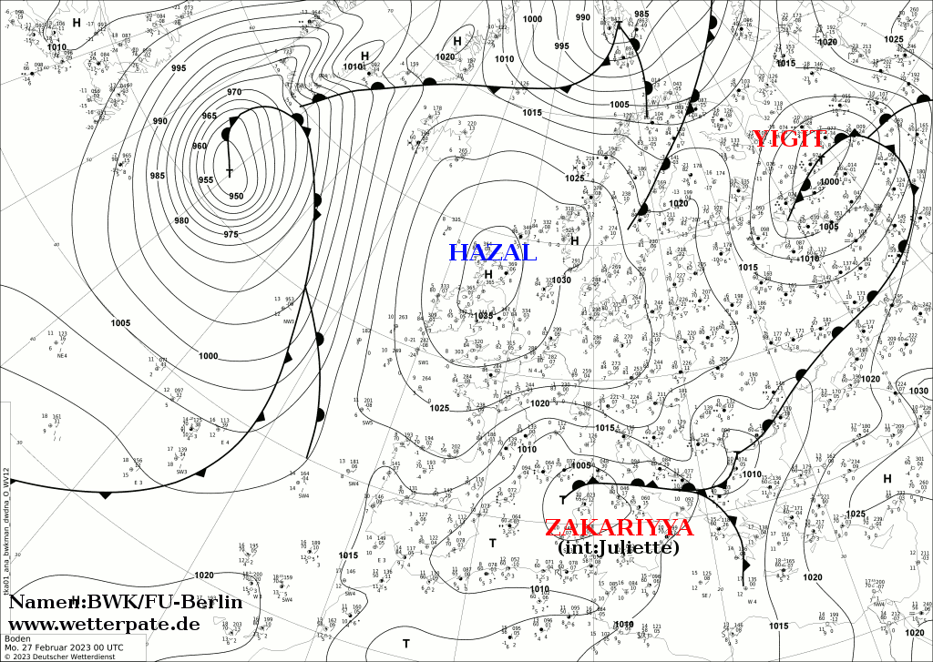
- ^ "Analyse Surface 21-01-23". Deutscher Wetterdienst (in German). Free University of Berlin. 21 January 2023. Archived from the original on 15 February 2023. Retrieved 15 February 2023.
- ^ Southern Africa: Tropical Cyclone Freddy - Flash Update No. 7 (14 March 2023) (PDF) (Report). 14 March 2023. Archived (PDF) from the original on 14 March 2023. Retrieved 17 March 2023 – via ReliefWeb.
{{cite report}}: Unknown parameter|agency=ignored (help) - ^ Jack McBrams (17 March 2023). "Cyclone Freddy affects 500,000 people in Malawi: UN". Yahoo news. Retrieved 17 March 2023.
- ^ Centre for Research on the Epidemiology of Disasters. "EM-DAT: The Emergency Events Database". Université catholique de Louvain.
- ^ "Taiwanese Fishing Vessel Disappears With Its Sixteen Crew Members". Le Matinal. 26 February 2023. Archived from the original on 16 March 2023. Retrieved 17 March 2023.
- ^ "Cyclone Freddy claims 2 lives in Manicaland – Zimbabwe Situation". Archived from the original on 28 February 2023. Retrieved 17 March 2023.
- ^ Halpin, Blair Ensor, Nadine Porter and James (2023-02-16). "Cyclone Gabrielle: What we know about the nine people who've died". Stuff. Archived from the original on 2023-02-17. Retrieved 2023-02-18.
{{cite web}}: CS1 maint: multiple names: authors list (link) - ^ Whyte, Anna (2023-02-19). "Cyclone Gabrielle: PM warns tough calls to come as resilience 'tested like never before'". Stuff. Retrieved 2023-03-18.
- ^ "Analyse Surface 10-02-23". Deutscher Wetterdienst (in German). Free University of Berlin. 10 February 2023. Archived from the original on 15 February 2023. Retrieved 15 February 2023.
- ^ "Tropical Cyclone Outlook for the Northern Region, including the Gulf of Carpentaria. Issued at 2: 15 pm CST on Sunday 12 February 2023". Archived from the original on 1 April 2019. Retrieved 12 February 2023.
- ^ "Analyse_20230227". Free University of Berlin. Archived from the original (.GIF) on 28 February 2023. Retrieved 28 February 2023.
- ^ "Thousands forced from their homes amid southern Malaysia floods". Alijazeera.com. March 6, 2023. Retrieved March 6, 2023.
- ^ Rochabrun, Marcelo (14 March 2023). "Peru's Desert Coast Braces for More Deadly Rains From Cyclone". Bloomberg. Bloomberg News. Retrieved 20 March 2023.
- ^ Murphy, Hannah; Barker, Anne; Brann, Matt; Bieundurry, Tallulah (2023-05-03). "Indonesian fishermen who survived cyclone that killed eight off WA coast won't face charges". ABC News. Retrieved 2023-05-10.
- ^ "'Amang' leaves P12.34-M damage to agriculture". Philstar.com. Retrieved 2023-04-13.
- ^ a b "Cyclone Mocha Death Count Rises To 60 In Myanmar". NDTV.com. Retrieved 16 May 2023.
- ^ a b "မုန်တိုင်းကြောင့် သေဆုံးသွားရတဲ့ ရိုဟင်ဂျာများ". Radio Free Asia (in Burmese). Retrieved 16 May 2023.
- ^ a b "মহেশখালীতে ঘূর্ণিঝড়ে ৩ লবণচাষির মৃত্যু". Bhorer Kagoj (in Bengali). 15 May 2023. Archived from the original on 15 May 2023. Retrieved 15 May 2023.
- ^ "Two bodies found in Chinese fishing vessel crew search in the Indian Ocean". ABC News. 18 May 2023. Archived from the original on 19 May 2023. Retrieved 26 May 2023.
- ^ "Sri Lanka Navy conducts risky diving operation at overturned Chinese fishing vessel in high seas". Retrieved 26 May 2023.
- ^ Healy, Shane Tenorio (2023-05-27). "Searches for missing swimmers called off". The Guam Daily Post. Retrieved 2023-05-27.
- ^ "One dead as Typhoon Mawar lashes Taiwan". news.com.au. May 29, 2023. Retrieved May 29, 2023.
- ^ Situational Report No. 8 for TC Betty (2023) (PDF) (Report). National Disaster Risk Reduction and Management Council. June 1, 2023. Retrieved June 1, 2023.
- ^ SitRep No. 8 for Combined Effects of Southwest Monsoon enhanced by TC DODONG (2023) (PDF) (Report). National Disaster Risk Reduction and Management Council. July 21, 2023. Retrieved July 21, 2023.
- ^ "Situation Report No. 10 for the Combined Effects of Southwest Monsoon and TC EGAY (2023)". National Disaster Risk Reduction and Management Council. July 27, 2023. Retrieved July 30, 2023.
- ^ "台風6号 沖縄に最接近 車庫倒壊 下敷き男性死亡" (in Japanese). FNNプライムオンライン. 2 August 2023. Retrieved 2 August 2022.
- ^ "Tropical Cyclone Heat Potential Seven Basins". NOAA. Archived from the original on 12 May 2021. Retrieved 20 October 2021.
- ^ "Thousands forced from their homes amid southern Malaysia floods". Alijazeera.com. March 6, 2023. Retrieved March 6, 2023.
External links
| Tropical cyclone year articles (2020–present) |
|---|
| 2020, 2021, 2022, 2023, 2024, Post-2024 |
Regional Specialized Meteorological Centers
- US National Hurricane Center. (RSMC Miami) – North Atlantic, Eastern Pacific
- Central Pacific Hurricane Center (RSMC Honolulu) – Central Pacific
- Japan Meteorological Agency (RSMC Tokyo) – West Pacific
- India Meteorological Department (RSMC New Delhi) – Bay of Bengal and the Arabian Sea
- Météo-France – La Reunion (RSMC La Réunion) – South-West Indian Ocean from 30°E to 90°E
- Fiji Meteorological Service (RSMC Nadi) – South Pacific, west of 160°E, north of 25° S
Tropical Cyclone Warning Centers
- Meteorology, Climatology, and Geophysical Agency of Indonesia (TCWC Jakarta) – South Indian Ocean from 90°E to 141°E, generally north of 10°S
- Australian Bureau of Meteorology (TCWC Melbourne) – South Indian Ocean & South Pacific Ocean from 90°E to 160°E, generally south of 10°S
- Papua New Guinea National Weather Service (TCWC Port Moresby) – South Pacific Ocean from 141°E to 160°E, generally north of 10°S
- Meteorological Service of New Zealand Limited (TCWC Wellington) – South Pacific west of 160°E, south of 25°S
Other Warning Centres
- Philippine Atmospheric, Geophysical and Astronomical Services Administration – Monitors the West Pacific
- Brazilian Navy Hydrography Center - Marine Meteorological Service – Monitors the South Atlantic
- US Joint Typhoon Warning Centre – Monitors the East Pacific, Central Pacific, West Pacific, South Pacific, North Indian Ocean and South-West Indian Ocean