Rozdolne Raion: Difference between revisions
m Disambiguating links to Crimea (disambiguation) (link changed to Republic of Crimea (Russia)) using DisamAssist. |
No edit summary Tag: Disambiguation links added |
||
| Line 59: | Line 59: | ||
|footnotes = |
|footnotes = |
||
}} |
}} |
||
'''Rozdolne Raion''' ({{lang-uk|Роздольненський район}}, {{lang-ru|Раздольненский район}}, {{lang-crh|Aqşeyh rayonı}}) is |
'''Rozdolne Raion''' ({{lang-uk|Роздольненський район}}, {{lang-ru|Раздольненский район}}, {{lang-crh|Aqşeyh rayonı}}) is a district ([[raion]]) within the [[Autonomous Republic of Crimea]], a territory internationally recognized as part of [[Ukraine]], but since 2014 occupied and incorporated by Russia as the [[Republic of Crimea]]. Its administrative center is the [[urban-type settlement]] of [[Rozdolne]]. Population: {{Crimea-census2014|30,633|punct=.}} |
||
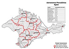
[[File:AR Crimea 2020 subdivisions.jpg|left|thumb|In July 2020, the Verkhovna Rada approved an administrative reform in Crimea]] |
[[File:AR Crimea 2020 subdivisions.jpg|left|thumb|In July 2020, the Verkhovna Rada approved an administrative reform in Crimea]] |
||
Revision as of 11:07, 1 June 2024
Rozdolne raion
Aqşeyh rayonı | |
|---|---|
 Village (selo) Syeverne, Rozdolnensky District | |
 Raion location within Crimea | |
| Country | Disputed: |
| Republic | Crimea |
| Capital | Rozdolne |
| Subdivisions | List
|
| Area | |
| • Total | 1,231 km2 (475 sq mi) |
| Population (2014) | |
| • Total | 30,633 |
| • Density | 25/km2 (64/sq mi) |
| Time zone | UTC+3 (MSK) |
| Dialing code | +380-6553 |
| Website | http://razdolnoe.rk.gov.ru |
Rozdolne Raion (Template:Lang-uk, Russian: Раздольненский район, Template:Lang-crh) is a district (raion) within the Autonomous Republic of Crimea, a territory internationally recognized as part of Ukraine, but since 2014 occupied and incorporated by Russia as the Republic of Crimea. Its administrative center is the urban-type settlement of Rozdolne. Population: 30,633 (2014 Census).[1]

2020 Ukrainian Administrative Reform
In July 2020, Ukraine conducted an administrative reform throughout its de jure territory. This included Crimea, which was at the time occupied by Russia, and is still ongoing as of October 2023. Crimea was reorganized from 14 raions and 11 municipalities into 10 raions, with municipalities abolished altogether.
Rozdolne Raion was abolished, and its territories to become a part of Perekop Raion, but this has not yet been implemented due to the ongoing Russian occupation.[2]
Demographics
According to the 2001 Ukrainian census, the raion had a population of 37,185. Ukrainians and Russians are the two biggest ethnic groups in the district, accounting for roughly 40% of the population respectively. Crimean Tatars constitute a significant minority. Rural areas are often Ukrainian-speaking, while the Russian language is used by the vast majority in population centers. Crimean Tatar is spoken by a significant share of the population in almost every settlement and dominates in three settlements in the district. The historic Black Sea German population mostly migrated to Germany under the right of return as Spätaussiedler, or still resides in Siberia and Kazakhstan, to where they got deported in 1941.[3][4]
Notable people
- Dmytro Brovkin (born 1984), Ukrainian football player born in Kukushkine
References
- ^ Russian Federal State Statistics Service (2014). "Таблица 1.3. Численность населения Крымского федерального округа, городских округов, муниципальных районов, городских и сельских поселений" [Table 1.3. Population of Crimean Federal District, Its Urban Okrugs, Municipal Districts, Urban and Rural Settlements]. Федеральное статистическое наблюдение «Перепись населения в Крымском федеральном округе». ("Population Census in Crimean Federal District" Federal Statistical Examination) (in Russian). Federal State Statistics Service. Retrieved January 4, 2016.
- ^ "Про утворення та ліквідацію районів". Офіційний вебпортал парламенту України (in Ukrainian). Retrieved 2023-10-16.
- ^ https://web.archive.org/web/20120828162929/http://sf.ukrstat.gov.ua/perepis1.htm#_jaz
- ^ https://socialdata.org.ua/projects/mova-2001/


