Tiruchirappalli district: Difference between revisions
| Line 10: | Line 10: | ||
==Geography== |
==Geography== |
||
Tiruchirapalli district lies at the heart of Tamil Nadu. The district has an area of 4,404 square kilometers. It is bounded in the northwest by Namakkal District, in the northeast by [[Perambalur]] District, in the east by [[Thanjavur]] District, in the southeast by [[Pudukkottai]] District, in the south by [[Madurai]] district, in the southwest by [[Dindigul]] District and, in the west by [[Karur]] District. Kaveri river flows through the length of the district and is the principal source of irrigation and water supply.kaveri river is very broad |
Tiruchirapalli district lies at the heart of Tamil Nadu. The district has an area of 4,404 square kilometers. It is bounded in the northwest by Namakkal District, in the northeast by [[Perambalur]] District, in the east by [[Thanjavur]] District, in the southeast by [[Pudukkottai]] District, in the south by [[Madurai]] district, in the southwest by [[Dindigul]] District and, in the west by [[Karur]] District. Kaveri river flows through the length of the district and is the principal source of irrigation and water supply.kaveri river is very broad river at the entry of trichy District. |
||
==Demographics== |
==Demographics== |
||
Revision as of 04:51, 28 May 2009


Tiruchirapalli District (also known as Tiruchchirapalli District / Trichy District) is located along the Kaveri River in Tamil Nadu India. The main town in Tiruchirapalli District is the city of Tiruchirapalli also known as Trichy.
Geography
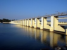
Tiruchirapalli district lies at the heart of Tamil Nadu. The district has an area of 4,404 square kilometers. It is bounded in the northwest by Namakkal District, in the northeast by Perambalur District, in the east by Thanjavur District, in the southeast by Pudukkottai District, in the south by Madurai district, in the southwest by Dindigul District and, in the west by Karur District. Kaveri river flows through the length of the district and is the principal source of irrigation and water supply.kaveri river is very broad river at the entry of trichy District.
Demographics
It had a population of 2,418,366 as of 2001. It is 47.10% urbanised. [2] The district has a literacy of 79.16%, higher than the state's average. Tamil is the principal language spoken and Tamils are the predominant linguistic group in the district. Hindus formed the majority of the population at 84.39% of the population followed by Christians at 9.02%, Muslims at 6.46% and others at 0.12%.[1]
Taluks
Tiruchirapalli District consists of 8 Taluks:
- Manapparai
- Srirangam
- Tiruchirapalli
- Lalgudi
- Manachanallur
- Thuraiyur
- Musiri
- Thottiyam
Urban Centres
Tiruchirapalli District consists of the following urban centres:
- Trichy city
- Manapparai town
- Thuraiyur town
- Thuvakudi town
- Lalgudi town panchayat
- Manachanallur town panchayat
- Musiri town panchayat
- Thottiyam town panchayat
- kollimalai tourist town
Major Industries
- Boiler Manufacturing Industries
- Cement Factories
- Light and heavy engineering
- Leather Tanneries
- Food processing Industries
- Sugar Mills
- (Traditional) Cigar Making (village) Industries.
- Hosiery and garments (to a small extent)
- IT/BPO
Natural Resources / Water bodies
- River Cauvery
- River Coleeron
Animal husbandry
The district has a large cattle and poultry population.[1]
Major Crops
The rivers Cauvery and Coleeron start branching out to form the Cauvery delta irrigating vast tracts of land in the district.
- Rice (vast tracts)
- Sugarcane (vast tracts)
- Banana/plantain
- Coconut
- Cotton (small tracts)
- betel
- Corn
Educational Institutions
- National Institute of Technology(Trichy), Thuvakudi
- Bharathidasan Institute of Management
- Central Banana Research Institute, Siruganur
- state instuite of hotal mangament and catring tech,Thuvakudi
References
External links

