
Miami Beach, Florida: Difference between revisions
| Line 148: | Line 148: | ||
According to the [[Morgan Quitno|Morgan Quitno Awards]], Miami Beach is one of the most dangerous small cities (population between 75,000 and 99,999) in the country.<ref>{{cite web|url=http://www.morganquitno.com/cit06pop.htm#25 |title=City Crime Rankings by Population Group |publisher=Morganquitno.com |date= |accessdate=2009-04-21}}</ref> |
According to the [[Morgan Quitno|Morgan Quitno Awards]], Miami Beach is one of the most dangerous small cities (population between 75,000 and 99,999) in the country.<ref>{{cite web|url=http://www.morganquitno.com/cit06pop.htm#25 |title=City Crime Rankings by Population Group |publisher=Morganquitno.com |date= |accessdate=2009-04-21}}</ref> |
||
Each December, The city plays host to the major contemporary art exhibition [[Art Basel Miami Beach]]. In November of 2007 and 2009, a multi-media art festival ("Sleepless Night") was held based on [[Nuit Blanche]].[http://www.jaunted.com/story/2007/10/17/162629/27/travel/Sleep+When+You+Die:+Miami%27s+Sleepless+Night+][http://www.miamiherald.com/news/miami-dade/story/1321135.html] |
Each December, The city plays host to the major contemporary art exhibition [[Art Basel Miami Beach]]. In November of 2007 and 2009, a multi-media art festival ("Sleepless Night") was held based on [[Nuit Blanche]].[http://www.jaunted.com/story/2007/10/17/162629/27/travel/Sleep+When+You+Die:+Miami%27s+Sleepless+Night+][http://www.miamiherald.com/news/miami-dade/story/1321135.html][http://www.sleeplessnight.org] |
||
==Geography and climate== |
==Geography and climate== |
||
Revision as of 20:32, 15 January 2010
City of Miami Beach | |
|---|---|
 Southern portion of Miami Beach with downtown Miami in background | |
| Nickname: The Beach | |
 Location in Miami-Dade County and the state of Florida | |
 U.S. Census Bureau map showing city limits | |
| Country | United States |
| State | Florida |
| County | Miami-Dade |
| Incorporated | March 26, 1915 |
| Government | |
| • Mayor | Matti Herrera Bower |
| Area | |
| • City | 18.7 sq mi (48.5 km2) |
| • Land | 7.0 sq mi (18.2 km2) |
| • Water | 11.7 sq mi (30.2 km2) 62.37% |
| Elevation | 3 ft (1 m) |
| Population (2005) | |
| • City | 87,925 |
| • Density | 12,502.1/sq mi (4,829.5/km2) |
| • Metro | 5,422,200 |
| Time zone | UTC-5 (EST) |
| • Summer (DST) | UTC-4 (EDT) |
| Zip | 33109, 33139, 33140, 33141. |
| Area code(s) | 305, 786 |
| FIPS code | 12-45025Template:GR |
| GNIS feature ID | 0286750Template:GR |
| Website | www.miamibeachfl.gov |
Miami Beach is a city in Miami-Dade County, Florida, United States. The city was incorporated on March 26, 1915.[1] It is located on a barrier island between Biscayne Bay and the Atlantic Ocean; the Bay separates Miami Beach from the city of Miami, Florida. The city is often referred to under the umbrella term of "Miami," despite being a distinct municipality. As of the 2000 census, the city had a total population of 87,933. 55.5% of the population was foreign born.[2] A 2005 population estimate for the city was 87,925.[3] Miami Beach has been one of America's pre-eminent beach resorts for almost a century.
Description
In 1979 Miami Beach's Art Deco Historic District was listed on the National Register of Historic Places. The Art Deco District is the largest collection of Art Deco architecture in the world and comprises hundreds of hotels, apartments and other structures erected between 1923 and 1943. Mediterranean, Streamline Moderne and Art Deco are all represented in the District. The Historic District is bounded by the Atlantic Ocean on the East, Lenox Court on the West, 6th Street on the South and Dade Boulevard along the Collins Canal to the North. The movement to preserve the Art Deco District's architectural heritage was led by former interior designer Barbara Capitman, who now has a street in the District named in her honor.
Government
Miami Beach is governed by a Mayor and 6 Commissioners. The mayor runs commission meetings and the mayor and all commissioners have equal voting power. The Mayor serves for terms of 2 years with a term limit of 3 terms and commissioners serve for terms of 4 years and are limited to 2 terms. Commissioners are voted for by region and every two years 3 commission seats are voted upon. A city manager is responsible for administering governmental operations.
As of January 2009 the Mayor is Matti Herrera Bower. The Commissioners are: Saul Gross, Jerry Libbin, Victor Diaz, Ed Tobin, Deede Weithorn and Jonah Wolfson.
Culture
Image and cultural depictions
South Beach (also known as SoBe, or simply The Beach, the area from 1st street to about 25th street) is one of the more popular areas of Miami Beach. Topless sunbathing is tolerated on certain designated areas of the beach. Before the TV show Miami Vice helped make the area popular, SoBe was under urban blight, with vacant buildings and a high crime rate. Today, it is considered one of the richest commercial areas on the beach, yet poverty and crime still remain in some places near the area.[4]
Miami Beach, particularly Ocean Drive of what is now the Art Deco District, was also featured prominently in the 1983 feature film Scarface and the Birdcage.
The New World Symphony Orchestra is based in Miami Beach, Florida, under the direction of Michael Tilson Thomas.
Lincoln Road is a nationally known spot for great outdoor dining, bicycling, rollerblading and shopping.[citation needed]
Jewish population
The Miami Beach environs are home to a number of Orthodox Jewish communities with a network of well-established synagogues and yeshivas. It is also a magnet for Jewish families, retirees, and particularly snowbirds when the cold winter sets in to the north. They range from the Followers to the Modern Orthodox to the Haredi and Hasidic - including many rebbes who vacation there during the North American winter. There are a number of kosher restaurants and even kollels for post-graduate Talmudic scholars, such as the Miami Beach Community Kollel. Miami Beach had roughly 60,000 people in Jewish households, 62 percent of the total population, in 1982, but only 16,500, or 19 percent of the population, in 2004, said Ira Sheskin, a demographer at the University of Miami who conducts surveys once a decade.[citation needed]
Miami Beach is home to the Holocaust Memorial on Miami Beach.
Other
According to the Morgan Quitno Awards, Miami Beach is one of the most dangerous small cities (population between 75,000 and 99,999) in the country.[5]
Each December, The city plays host to the major contemporary art exhibition Art Basel Miami Beach. In November of 2007 and 2009, a multi-media art festival ("Sleepless Night") was held based on Nuit Blanche.[1][2][3]
Geography and climate

Miami Beach is located at 25°48′47″N 80°08′03″W / 25.813025°N 80.134065°W (25.813025, -80.134065).Template:GR
According to the United States Census Bureau, the city has a total area of 48.5 km2 (18.7 mi2). 18.2 km2 (7.0 mi2) of it is land and 30.2 km2 (11.7 mi2) of it (62.37%) is water.
It has a Tropical monsoon climate (Köppen Am)[6], with hot humid summers and warm winters. There is a marked wet season during the summer months, with dry winters that feature much lower humidity. Miami Beach is one of only a handful of U.S. locales that has never recorded snow or snow flurries in recorded weather history.
Miami Beach's location on the Atlantic Ocean, near its confluence with the Gulf of Mexico make it extraordinarily vulnerable to hurricanes and tropical storms. Despite only experiencing one direct hit from a major hurricane in recorded weather history, (Hurricane Cleo in 1964), the area has seen indirect contact from hurricanes Betsy (1965), Andrew (1992), Irene (1999), Michelle (2001), Katrina (2005), and Wilma (2005).
| Climate data for Miami Beach, FL | |||||||||||||
|---|---|---|---|---|---|---|---|---|---|---|---|---|---|
| Month | Jan | Feb | Mar | Apr | May | Jun | Jul | Aug | Sep | Oct | Nov | Dec | Year |
| Source: The Weather Channel[7] | |||||||||||||
Surrounding areas
Demographics
As of the censusTemplate:GR of 2000, there were 87,933 people, 46,194 households, and 18,339 families residing in the city. The population density was 4,829.5/km2 (12,502.1/mi2). There were 59,723 housing units at an average density of 3,280.1/km2 (8,491.2/mi2). The racial makeup of the city was 86.74% White (40.9% were Non-Hispanic Whites,)[8] 4.03% African American, 0.23% Native American, 1.37% Asian, 0.04% Pacific Islander, 4.05% from other races, and 3.53% from two or more races. Hispanic or Latino of any race were 53.45% of the population.
There were 46,194 households out of which 14.0% had children under the age of 18 living with them, 27.4% were married couples living together, 8.5% had a female householder with no husband present, and 60.3% were non-families. 48.7% of all households were made up of individuals and 14.8% had someone living alone who was sixty-five years of age or older. The average household size was 1.87 and the average family size was 2.76.
| Census | Pop. | Note | %± |
|---|---|---|---|
| 1920 | 644 | — | |
| 1930 | 6,494 | 908.4% | |
| 1940 | 28,012 | 331.4% | |
| 1950 | 46,282 | 65.2% | |
| 1960 | 63,145 | 36.4% | |
| 1970 | 87,072 | 37.9% | |
| 1980 | 96,298 | 10.6% | |
| 1990 | 92,639 | −3.8% | |
| 2000 | 87,933 | −5.1% | |
| 2007 (est.) | 86,916 |
In the city the population was spread out with 13.4% under the age of 18, 7.8% from 18 to 24, 38.2% from 25 to 44, 21.3% from 45 to 64, and 19.2% who were sixty-five years of age or older. The median age was thirty-nine years. For every 100 females there were 105.0 males. For every 100 females age eighteen and over, there were 105.4 males.
The median income for a household in the city was $27,322, and the median income for a family was $33,440. Males had a median income of $33,964 versus $27,094 for females. The per capita income for the city was $27,853. About 17.0% of families and 21.8% of the population were below the poverty line, including 25.2% of those under age 18 and 24.5% of those age sixty-five or over.
As of 2000, speakers of Spanish as a first language accounted for 54.89% of residents, while English made up 32.75%, Portuguese was at 3.38%, French was at 1.66%, German at 1.12%, Italian 0.99%, and Russian was 0.85% of the population. Due to the large Jewish community, Yiddish made up 0.81% of speakers, and Hebrew was the mother tongue of 0.74% of the population.[9]
As of 2000, Miami Beach had the twenty-second highest percentage of Cuban residents in the US, with 20.51% of the populace.[10] It had the twenty-eighth highest percentage of Colombian residents in the US, at 4.4% of the city's population,[11] and the fourteenth highest percentage of Brazilian residents in the US, at 2.2% of the its population (tied with Hillside, New Jersey and Hudson, Massachusetts.)[12] It also had the twenty-seventh most Peruvians in the US, at 1.85%,[13] while it had the twenty-seventh highest percentage of Venezuelans, at 1.79% of all residents.[14] Miami Beach's Honduran community had the thirty-third highest percentage of residents, which comprised 1.03% of the population.[15] Its also home to the forty-first highest percentage of Nicaraguan residents, which made up 1.03% of the population.[16]
Economy
Prior to its dissolution, Windjammer Barefoot Cruises had its headquarters in Miami Beach.[17]
Education
Miami-Dade County Public Schools serves Miami Beach.
- North Beach Elementary
- South Pointe Elementary
- Biscayne Elementary
- Feinberg/Fisher K - 8 Center
- Treasure Island Elementary
- Ruth K. Broad/ Bay Harbor Elementary
- Nautilus Middle School (which is the only Public middle school for the Miami Beach area)
- Miami Beach Senior High School (which is the only Public high school for the Miami Beach area)
Private schools include Alexander S. Gross Hebrew Academy, Landow Yeshiva - Lubavitch Educational Center (Klurman Mesivta for Boys), and Mechina High School.
Neighborhoods


- Bayshore
- Sunset Islands I & II
- Sunset Islands III & IV
- Sunset Harbour
- The Townhomes at Sunset Harbour
- Biscayne Point
- Stillwater Drive Neighborhood
- City Center
- Collins Park
- Fisher Island (A small portion of the island)
- Flamingo/Lummus
- Flamingo Park
- Flamingo Park West
- North Ocean Drive Area
- South Beach
- La Gorce
- Allison Island
- Aqua Allison Island
- La Gorce Island
- La Gorce Pine Tree
- Lower North Bay Road Neighborhood
- Middle North Bay Road Neighborhood
- Nautilus
- Alton Road Neighborhood
- Lakeview/Surprise Lake
- Orchard Park
- North Shore
- Little Buenos Aires
- Normandy Fountain
- Park View Island
- Normandy Isles
- Normandie Sud
- Normandy Shores
- Oceanfront
- South Pointe
- SoFi (South of Fifth)
- Star Island, Palm Island, & Hibiscus Island
- Venetian Islands, including Belle Isle
- Biscayne Island
- Di Lido Island
- Rivo Alto Island
- San Marco Island
- San Marino Island
- West Avenue/Bay Road
- Lincoln West
Points of interest
- Cadillac Hotel
- Fillmore Miami Beach at the Jackie Gleason Theatre
- Flagler Monument Island
- Fontainebleau Hotel
- Versace Mansion (Casa Casuarina)
- Holocaust Memorial
- Lincoln Road
- Miami Beach Architectural District
- Miami Beach Botanical Garden
- Ocean Drive
- Ocean Spray Hotel
- South Beach
- Wolfsonian-FIU Museum
Sister cities
Miami Beach has 10 sister cities[18]
 Fortaleza, Brazil [19]
 Brampton, Canada[20]
 Santa Marta, Colombia
 Ceský Krumlov, Czech Republic
 Nahariya, Israel
 Pescara, Italy
 Fujisawa, Japan
 Cozumel, Mexico
 Ica, Peru
 Almonte, Spain
See also
- Neighborhoods of Miami Beach, Florida
- List of upscale shopping districts
- South Florida
- Miami-Dade County
- Miami Beach Police Department
- Miami Modern Architecture
- John S. Collins
- Carl G. Fisher
- Collins Bridge
- Rosie the Elephant
- Fair Game (1996 film)
- Doral Hotel
- Ocean Drive
- Julia Tuttle Causeway
- Macarthur Causeway
- Venetian Causeway
- Spring Break
- 8th & Ocean
References
- ^ Ruby Leach Carson. 40 Years of Miami Beach. p. 13.
{{cite book}}: External link in|title= - ^ "| FAIR: City Factsheet: Miami Beach, Florida". Fairus.org. 2006-07-01. Retrieved 2009-04-21.
- ^ http://www.census.gov/popest/cities/tables/SUB-EST2005-04-12.xls
- ^ MSNBC: South Beach: Life imitates art, quite vicely www.msnbc.com
- ^ "City Crime Rankings by Population Group". Morganquitno.com. Retrieved 2009-04-21.
- ^ "Köppen Climate Map Aw=tropical". .johnabbott.qc.ca. Retrieved 2009-04-21.
- ^ http://www.weather.com/weather/wxclimatology/monthly/graph/33140?from=36hr_bottomnav_undeclared |title=Monthly Averages for Miami Beach, FL |accessdate=2009-11-07 |year=2009 |publisher=The Weather Channel }}
- ^ "Demographics of Miami Beach, FL". MuniNetGuide.com. Retrieved 2007-11-01.
- ^ "MLA Data Center Results of Miami Beach, FL". Modern Language Association. Retrieved 2007-11-01.
- ^ "Ancestry Map of Cuban Communities". Epodunk.com. Retrieved 2007-11-01.
- ^ "Ancestry Map of Colombian Communities". Epodunk.com. Retrieved 2007-11-01.
- ^ "Ancestry Map of Brazilian Communities". Epodunk.com. Retrieved 2007-11-01.
- ^ "Ancestry Map of Peruvian Communities". Epodunk.com. Retrieved 2007-11-01.
- ^ "Ancestry Map of Venezuelan Communities". Epodunk.com. Retrieved 2007-11-01.
- ^ "Ancestry Map of Honduran Communities". Epodunk.com. Retrieved 2007-11-01.
- ^ "Ancestry Map of Nicaraguan Communities". Epodunk.com. Retrieved 2007-11-01.
- ^ "Contact Us." Windjammer Barefoot Cruises. February 2, 2004. Retrieved on January 9, 2010.
- ^ "Miami Beach Sister Cities Program". Miamibeachsistercities.com. Retrieved 2009-04-21.
- ^ "Miami Beach Sister Cities program - Fortaleza, Brazil".
- ^ "Historic Sister City Agreemtn Between Brampton and Miami Beach, Florida" (PDF). City of Brampton, Canada. 2008-10-03. Retrieved 2008-10-05.
Gallery
-
 The historical Art Deco District at South Beach during the night.
 -
 The Art Deco District at South Beach during the day.
 -
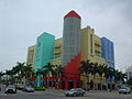 Colorful new building blends in with the historic Art Deco


External links
Official sites
Photos
- Miami Beach Architecture Photos
- The lifeguard towers of Miami Beach
- Photographs of Miami Beach From the State Library & Archives of Florida
- Photos of Miami Beach, Miami and surrounding areas
Other
- Miami Design Preservation League – Non-profit Organization for the preservation of Miami Beach Architectural History
- Miami's Southeast Coast - Biscayne Bay Watershed - Florida DEP
Municipalities and communities of Miami-Dade County, Florida, United States | ||
|---|---|---|
| Cities |  | |
| Towns | ||
| Villages | ||
| CDPs |
| |
| Unincorporated communities | ||
| Ghost town | ||
| Indian reservation | ||
| Footnotes | ‡This populated place also has portions in an adjacent county or counties | |