Samarkand: Difference between revisions
SharabSalam (talk | contribs) Reverted 1 edit by 2001:569:73D0:6A00:4CAF:15A3:4846:6F9B (talk): Unsourced (TW) |
|||
| Line 490: | Line 490: | ||
|} |
|} |
||
== |
== Randpm photo gallery == |
||
<center> |
<center> |
||
<gallery> |
<gallery> |
||
Revision as of 21:05, 22 February 2019
Samarkand
Samarqand • سمرقند | |
|---|---|
| Coordinates: 39°42′N 66°59′E / 39.700°N 66.983°E | |
| Country | |
| Region | Samarqand Region |
| Settled | 8th century BC |
| Government | |
| • Type | City Administration |
| • Hakim (Mayor) | Erkinjon Turdimov |
| Area | |
| • City | 108 km2 (42 sq mi) |
| Elevation | 702 m (2,303 ft) |
| Population (2018) | |
| • City | 530,000 |
| • Density | 4,900/km2 (13,000/sq mi) |
| • Metro | More 1,000,000 |
| Time zone | UTC+5 ( ) |
| Postal code | 140100 |
| Website | www |
Samarkand (/ˈsæmərkænd/; Uzbek language: Samarqand; Template:Lang-fa; Template:Lang-ru), alternatively Samarqand, is a city in modern-day Uzbekistan, and is one of the oldest continuously inhabited cities in Central Asia. There is evidence of human activity in the area of the city from the late Paleolithic era, though there is no direct evidence of when Samarkand was founded; some theories propose that it was founded between the 8th and 7th centuries BC. Prospering from its location on the Silk Road between China and the Mediterranean, at times Samarkand was one of the greatest cities of Central Asia.[1]
By the time of the Achaemenid Empire of Persia, it was the capital of the Sogdian satrapy. The city was taken by Alexander the Great in 329 BC, when it was known by its Greek name of Marakanda.[2] The city was ruled by a succession of Iranian and Turkic rulers until the Mongols under Genghis Khan conquered Samarkand in 1220. Today, Samarkand is the capital of Samarqand Region and Uzbekistan's second largest city.[3]
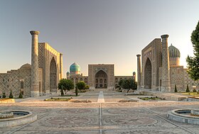
The city is noted for being an Islamic centre for scholarly study. In the 14th century it became the capital of the empire of Timur (Tamerlane) and is the site of his mausoleum (the Gur-e Amir). The Bibi-Khanym Mosque, rebuilt during the Soviet era, remains one of the city's most notable landmarks. Samarkand’s Registan square was the ancient centre of the city, and is bound by three monumental religious buildings. The city has carefully preserved the traditions of ancient crafts: embroidery, gold embroidery, silk weaving, engraving on copper, ceramics, carving and painting on wood.[4] In 2001, UNESCO added the city to its World Heritage List as Samarkand – Crossroads of Cultures.
Modern-day Samarkand is divided into two parts: the old city, and the new city developed during the days of the Russian Empire and Soviet Union. The old city includes historical monuments, shops and old private houses, while the new city includes administrative buildings along with cultural centres and educational institutions.[5]
| UNESCO World Heritage Site | |
|---|---|
 | |
| Criteria | Cultural: i, ii, iv |
| Reference | 603 |
| Inscription | 2001 (25th Session) |
| Area | 1,123 ha |
| Buffer zone | 1,369 ha |
Etymology
The name originates in the Sogdian samar, "stone, rock", and kand, "fort, town".[6]
History
Early history

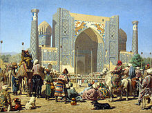
Along with Bukhara,[7] Samarkand is one of the oldest inhabited cities in Central Asia, prospering from its location on the trade route between China and the Mediterranean (Silk Road).
Archeological excavations held within the city limits (Syob and midtown) as well as suburban areas (Hojamazgil, Sazag'on) unearthed forty-thousand-year-old evidence of human activity, dating back to the Late Paleolithic era. A group of Mesolithic era (12th–7th millennium BC) archeological sites were discovered at Sazag'on-1, Zamichatosh and Okhalik (suburbs of the city). The Syob and Darg'om canals, supplying the city and its suburbs with water, appeared around the 7th to 5th centuries BC (early Iron Age). There is no direct evidence when Samarkand was founded. Researchers of the Institute of Archeology of Samarkand argue for the existence of the city between the 8th and 7th centuries BC.
Samarkand has been one of the main centres of Sogdian civilization from its early days. By the time of the Achaemenid dynasty of Persia it had become the capital of the Sogdian satrapy.
Hellenistic period
Alexander the Great conquered Samarkand in 329 BC. The city was known as Maracanda by the Greeks.[8] Written sources offer small clues as to the subsequent system of government.[9] They tell of an Orepius who became ruler "not from ancestors, but as a gift of Alexander".[10]
While Samarkand suffered significant damage during Alexander's initial conquest, the city recovered rapidly and flourished under the new Hellenic influence. There were also major new construction techniques; oblong bricks were replaced with square ones and superior methods of masonry and plastering were introduced.[11]
Alexander's conquests introduced classical Greek culture into Central Asia; for a time, Greek aesthetics heavily influenced local artisans. This Hellenistic legacy continued as the city became part of various successor states in the centuries following Alexander's death, i.e. the Seleucid Empire, Greco-Bactrian Kingdom and Kushan Empire (even though the Kushana themselves originated in Central Asia). After the Kushan state lost control of Sogdia, during the 3rd century AD, Samarkand went into decline as a centre of economic, cultural and political power. It did not significantly revive until the 5th century AD.
Pre-Mongol period

Samarkand was conquered by the Persian Sassanians around 260 AD. Under Sassanian rule, the region became an essential site for Manichaeism, and facilitated the dissemination of the religion throughout Central Asia.[12]
After the Hephtalites (Huns) conquered Samarkand, they controlled it until the Göktürks, in an alliance with the Sassanid Persians, won it at the Battle of Bukhara. The Turks ruled over Samarkand until they were defeated by the Sassanids during the Göktürk–Persian Wars.
After the Arab conquest of Iran, the Turks conquered Samarkand and held it until the Turkic khaganate collapsed due to wars with the Chinese Tang Dynasty. During this time the city became a protectorate and paid tribute to the ruling Tang. The armies of the Umayyad Caliphate under Qutayba ibn Muslim captured the city in around 710 from Turks.[12]
During this period, Samarkand was a diverse religious community and was home to a number of religions, including Zoroastrianism, Buddhism,Hinduism, Manichaeism, Judaism and Nestorian Christianity.[13] However, after the Arab conquest of Sogdiana, Islam became the dominant religion, with much of the population converting.[14]
Legend has it that during Abbasid rule,[15] the secret of papermaking was obtained from two Chinese prisoners from the Battle of Talas in 751, which led to the foundation of the first paper mill of the Islamic world in Samarkand. The invention then spread to the rest of the Islamic world, and from there to Europe.
Abbasid control of Samarkand soon dissipated and was replaced with that of the Samanids (862–999), though it must be noted that the Samanids were still nominal vassals of the Caliph during their control of Samarkand. Under Samanid rule the city became one of the capitals of the Samanid dynasty and an even more important link amongst numerous trade routes. The Samanids were overthrown by the Karakhanids around 1000. During the next two hundred years, Samarkand would be ruled by a succession of Turkic tribes, including the Seljuqs and the Khwarazm-Shahs.[16]
The 10th-century Iranian author Istakhri, who travelled in Transoxiana, provides a vivid description of the natural riches of the region he calls "Smarkandian Sogd":
I know no place in it or in Samarkand itself where if one ascends some elevated ground one does not see greenery and a pleasant place, and nowhere near it are mountains lacking in trees or a dusty steppe... Samakandian Sogd... [extends] eight days travel through unbroken greenery and gardens... . The greenery of the trees and sown land extends along both sides of the river [Sogd]... and beyond these fields is pasture for flocks. Every town and settlement has a fortress... It is the most fruitful of all the countries of Allah; in it are the best trees and fruits, in every home are gardens, cisterns and flowing water.
Mongol period
The Mongols conquered Samarkand in 1220. Although Genghis Khan "did not disturb the inhabitants [of the city] in any way", according to Juvaini he killed all who took refuge in the citadel and the mosque, pillaged the city completely and conscripted 30,000 young men along with 30,000 craftsmen. Samarkand suffered at least one other Mongol sack by Khan Baraq to get treasure he needed to pay an army. It remained part of the Chagatai Khanate (one of four Mongol successor realms) until 1370.
The Travels of Marco Polo, where Polo records his journey along the Silk Road, describes Samarkand as "a very large and splendid city..."
The Yenisei area had a community of weavers of Chinese origin and Samarkand and Outer Mongolia both had artisans of Chinese origin seen by Changchun.[17] After the Mongol conquest of Central Asia by Genghis Khan, foreigners were chosen as administrators and co-management with Chinese and Qara-Khitays (Khitans) of gardens and fields in Samarqand was put upon the Muslims as a requirement since Muslims were not allowed to manage without them.[18][19]
The khanate allowed the establishment of Christian bishoprics (see below).
Timur(id) rule (14th-15th centuries)
Ibn Battuta visited in 1333, and called the city "one of the greatest and finest of cities, and most perfect of them in beauty." He also noted the orchards were supplied water via norias.[20]
In 1365, a revolt against Chagatai Mongol control occurred in Samarkand.[21]
In 1370 the conqueror Timur (Tamerlane), the founder and ruler of the Timurid Empire, made Samarkand his capital. During the next 35 years, he rebuilt most of the city and populated it with the great artisans and craftsmen from across the empire. Timur gained a reputation as a patron of the arts and Samarkand grew to become the centre of the region of Transoxiana. Timur's commitment to the arts is evident in the way he was ruthless with his enemies but merciful towards those with special artistic abilities, sparing the lives of artists, craftsmen and architects so that he could bring them to improve and beautify his capital. He was also directly involved in his construction projects and his visions often exceeded the technical abilities of his workers. Furthermore, the city was in a state of constant construction and Timur would often request buildings to be done and redone quickly if he was unsatisfied with the results.[22] Timur made it so that the city could only be reached by roads and also ordered the construction of deep ditches and walls, that would run five miles (8.0 km) in circumference, separating the city from the rest of its surrounding neighbors.[23] During this time the city had a population of about 150,000.[24] This great period of reconstruction is encapsulated in the account of Henry III's ambassador, Ruy Gonzalez de Clavijo, who was stationed there between 1403 and 1406. During his stay the city was typically in a constant state of construction. "The Mosque which Timur had caused to be built in memory of the mother of his wife...seemed to us the noblest of all those we visited in the city of Samarkand, but no sooner had it been completed than he begun to find fault with its entrance gateway, which he now said was much too low and must forthwith be pulled down."[25]
Between 1424 and 1429, the great astronomer Ulugh Beg built the Samarkand Observatory. The sextant was 11 metres long and once rose to the top of the surrounding three-storey structure, although it was kept underground to protect it from earthquakes. Calibrated along its length, it was the world's largest 90-degree quadrant at the time.[26] However, the observatory was destroyed by religious fanatics in 1449.[26][27]
Post-Timurid regional rulers
This article needs to be updated. (November 2011) |
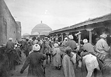

In 1500 the Uzbek nomadic warriors took control of Samarkand.[24] The Shaybanids emerged as the Uzbek leaders at or about this time.
In the second quarter of the 16th century, the Shaybanids moved their capital to Bukhara and Samarkand went into decline. After an assault by the Afshar shahinshah Nader Shah the city was abandoned in the 18th century, about 1720 or a few years later.[29]
From 1599 to 1756, Samarkand was ruled by the Ashtrakhanid branch of the Khanate of Bukhara.
From 1756 to 1868, Samarkand was ruled by the Manghud (Mongol) Emirs of Bukhara.[30]
Russian Tzarist and Soviet rule
The city came under imperial Russian rule after the citadel had been taken by a force under Colonel Konstantin Petrovich von Kaufman in 1868. Shortly thereafter the small Russian garrison of 500 men were themselves besieged. The assault, which was led by Abdul Malik Tura, the rebellious elder son of the Bukharan Emir, as well as Baba Beg of Shahrisabz and Jura Beg of Kitab, was repelled with heavy losses. Alexander Abramov became the first Governor of the Military Okrug, which the Russians established along the course of the Zeravshan River, with Samarkand as the administrative centre. The Russian section of the city was built after this point, largely to the west of the old city.
In 1886, the city became the capital of the newly formed Samarkand Oblast of Russian Turkestan and grew in importance still further when the Trans-Caspian railway reached the city in 1888.
It became the capital of the Uzbek SSR in 1925, before being replaced by Tashkent in 1930. During World War II, after Nazi Germany invaded the Soviet Union, a number of citizens of Samarqand were sent to the land of Smolensk, to fight the enemy. Many were taken captive or killed by the Nazis.[31][32]
Geography
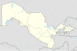
Samarkand is located in north-eastern Uzbekistan, in the Zarefshan River valley. Qarshi is located 135 km away. Road M37 connects it to Bukhara, 240 km away. Road M39 connects it to Tashkent, 270 km away. The Tajikistan border is about 35 km from Samarkand, the road leading to Dushanbe which is 210 km away. Road M39 connects it to Mazar-i-Sharif in Afghanistan, which is 340 km away.
Climate
Samarkand features a Mediterranean climate (Köppen climate classification Csa) that closely borders on a semi-arid climate (BSk) with hot, dry summers and relatively wet, variable winters that alternate periods of warm weather with periods of cold weather. July and August are the hottest months of the year with temperatures reaching, and exceeding, 40 °C (104 °F). Most of the sparse precipitation is received from December through April. January 2008 was particularly cold, and the temperature dropped to −22 °C (−8 °F)[33]
| Climate data for Samarkand (1981–2010) | |||||||||||||
|---|---|---|---|---|---|---|---|---|---|---|---|---|---|
| Month | Jan | Feb | Mar | Apr | May | Jun | Jul | Aug | Sep | Oct | Nov | Dec | Year |
| Record high °C (°F) | 23.2 (73.8) |
26.7 (80.1) |
31.7 (89.1) |
36.2 (97.2) |
39.5 (103.1) |
41.4 (106.5) |
42.4 (108.3) |
41.0 (105.8) |
38.6 (101.5) |
35.2 (95.4) |
29.9 (85.8) |
27.5 (81.5) |
42.4 (108.3) |
| Mean daily maximum °C (°F) | 6.8 (44.2) |
9.1 (48.4) |
14.2 (57.6) |
21.1 (70.0) |
26.4 (79.5) |
32.2 (90.0) |
34.1 (93.4) |
32.9 (91.2) |
28.3 (82.9) |
21.6 (70.9) |
15.3 (59.5) |
9.1 (48.4) |
20.9 (69.6) |
| Daily mean °C (°F) | 1.9 (35.4) |
3.6 (38.5) |
8.5 (47.3) |
14.9 (58.8) |
19.8 (67.6) |
25.0 (77.0) |
26.7 (80.1) |
25.2 (77.4) |
20.1 (68.2) |
13.6 (56.5) |
8.4 (47.1) |
3.8 (38.8) |
14.3 (57.7) |
| Mean daily minimum °C (°F) | −1.7 (28.9) |
−0.5 (31.1) |
4.0 (39.2) |
9.4 (48.9) |
13.5 (56.3) |
17.4 (63.3) |
18.9 (66.0) |
17.4 (63.3) |
12.7 (54.9) |
7.2 (45.0) |
3.4 (38.1) |
−0.2 (31.6) |
8.5 (47.3) |
| Record low °C (°F) | −25.4 (−13.7) |
−22 (−8) |
−14.9 (5.2) |
−6.8 (19.8) |
−1.3 (29.7) |
4.8 (40.6) |
8.6 (47.5) |
5.9 (42.6) |
0.0 (32.0) |
−6.4 (20.5) |
−18.1 (−0.6) |
−22.8 (−9.0) |
−25.4 (−13.7) |
| Average precipitation mm (inches) | 41 (1.6) |
46 (1.8) |
69 (2.7) |
60 (2.4) |
36 (1.4) |
6 (0.2) |
4 (0.2) |
1 (0.0) |
4 (0.2) |
17 (0.7) |
34 (1.3) |
47 (1.9) |
365 (14.4) |
| Average rainy days | 8 | 10 | 13 | 11 | 9 | 3 | 2 | 1 | 2 | 6 | 8 | 9 | 82 |
| Average snowy days | 9 | 7 | 3 | 0.3 | 0.1 | 0 | 0 | 0 | 0 | 0.3 | 2 | 6 | 28 |
| Average relative humidity (%) | 76 | 74 | 70 | 63 | 54 | 42 | 42 | 43 | 47 | 59 | 68 | 74 | 59 |
| Mean monthly sunshine hours | 132.9 | 130.9 | 169.3 | 219.3 | 315.9 | 376.8 | 397.7 | 362.3 | 310.1 | 234.3 | 173.3 | 130.3 | 2,953.1 |
| Source 1: Pogoda.ru.net[34] | |||||||||||||
| Source 2: NOAA (sun, 1961–1990)[35] | |||||||||||||
People
This section relies largely or entirely on a single source. (July 2018) |
According to various independent sources, Tajiks (Persian-speaking people) are the major ethnic group in the city, while ethnic Uzbeks form a growing minority.[36] Exact figures are difficult to evaluate, since many people in Uzbekistan either identify as "Uzbek" even though they speak Tajik as their first language, or because they are registered as Uzbeks by the central government despite their Tajik language and identity. As explained by Paul Bergne:
During the census of 1926 a significant part of the Tajik population was registered as Uzbek. Thus, for example, in the 1920 census in Samarkand city the Tajiks were recorded as numbering 44,758 and the Uzbeks only 3301. According to the 1926 census, the number of Uzbeks was recorded as 43,364 and the Tajiks as only 10,716. In a series of kishlaks [villages] in the Khojand Okrug, whose population was registered as Tajik in 1920 e.g. in Asht, Kalacha, Akjar i Tajik and others, in the 1926 census they were registered as Uzbeks. Similar facts can be adduced also with regard to Ferghana, Samarkand, and especially the Bukhara oblasts.[36]
Religion
Historically, Samarkand was a diverse religious community. Before the 8th century Hinduism was mainly influenced in this area for centuries. Since the 8th century, when the Arabs entered Central Asia, Islam has become the main religion. According to some sources, approximately 90% of people are Muslims and Christianity and Judaism are minor religions.[citation needed]

Since the advent of Islam, many mosques, madrasas and mausoleum have been built and all of these make the city very attractive for tourists to visit. Many of these monuments were built during 14th–15th centuries by Tamerlane including the Registan Mosque and madrasas, the Bibi-Khanum Mosque, the Shakhi-Zinda compound and the Gur-Emir ensemble, as well as Ulugh-Beg's Observatory.
Because 90% of the population of Uzbekistan are Sunni Muslim, the city has got many islamic places.[37]
The Shia "Iranis"
There are many Shia towns in the Samarkand general area, where Shia Muslims are composed almost entirely of the deported Mervis; the old, approximately 100,000 strong population of Merv city and oasis (now in Turkmenistan) who were deported en masse by the Manghit king Shah Murad Beg in the course of the 1780s to the Zarafshan basin. They are known locally and identified by the Soviet censuses as the "Irani". They have their own mosques and mausoleums.
Christianity
Christians include: Russians, Koreans, Ukrainians and Armenians. Only a few churches hold services.
Samarkand, the ancient capital of Sogdiana, was an early Metropolitan Archbishopric of Nestorianism. As a crossroads for caravans between China, Persia and the Crimea, it was religiously tolerant. Even the Mongol Chagatai Khanate was. Marco Polo claims that Samarkand's founder (one of four successors to Genghis Khan) converted to Christianity; in any event his descendant and successor Algigidai (Eljigidey), ruling from 1327, allowed the Dominican Order to preach Catholicism and build a church in Samarkand dedicated to John the Baptist and wrote twice to Pope John XXII, who sent him two Dominican 'ambassadors'. In addition to Nestorians, there were Greek Melkite and Orthodox Christians, but now also a Latin Catholic community, which on 13 August 1329 became the Diocese of Samarcanda / Semiscanten(sis) (Latin), as a suffragan of the Metropolitan Archdiocese of Soltaniyeh which had been established in 1318 by papal bull Redemptor noster from the same pope. The Archdiocese was also entrusted to the Dominicans and was meant to become an ecclesiastical province covering the Mongol khanates. By 1400 it had been suppressed, after the demise of the tolerant khanate, having had two recorded incumbents:
- Tommaso di Mancasola, Dominican Order (O.P.) (August 21, 1329 – ?), the senior of the initial papal envoys
- Giovanni = John (1359? – ?).
Main sights
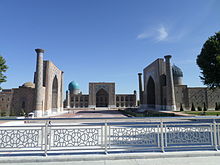


- The Registan, a famous example of Islamic architecture. It consists of three separate buildings:
- Madrasa of Ulugh Beg (1417–1420)
- Sher-Dor Madrasa (Lions Gate) (1619–1635/36).
- Tilla-Kori Madrasa (1647–1659/60).
- Bibi-Khanym Mosque (replica)
- Gur-e Amir Mausoleum (1404)
- Observatory of Ulugh Beg (1428–1429)
- Shah-i-Zinda necropolis (means "Living Tsar").[38] Small mosques and other monuments spread along a narrow passageway, some monuments date from the 18th century.[38]
- Historical site of Afrasiyab (7th century BC – 13th century)
- Siyob Bazaar
- Afrasiab Museum of Samarkand
Architecture

Timur initiated the building of Bibi Khanum after his campaign in India in 1398–1399. Before its reconstruction after an earthquake in 1897, Bibi Khanum had around 450 marble columns that were established with the help of 95 elephants that Timur had brought back from Hindustan. Also from India, artisans and stonemasons designed the mosque's dome, giving it its distinctiveness amongst the other buildings.[22]
The best-known structure in Samarkand is the mausoleum known as Gur-i Amir. It exhibits many cultures and influences from past civilizations, neighboring peoples, and especially those of Islam. Despite how much devastation the Mongols caused in the past to all of the Islamic architecture that had existed in the city prior to Timur's succession, much of the destroyed Islamic influences were revived, recreated, and restored under Timur. The blueprint and layout of the mosque itself follows the Islamic passion of geometry and other elements of the structure had been precisely measured. The entrance to the Gur-i Amir is decorated with Arabic calligraphy and inscriptions, the latter being a common feature in Islamic architecture. The attention to detail and meticulous nature of Timur is especially obvious when looking inside the building. Inside, the walls have been covered in tiles through a technique, originally developed in Iran, called "mosaic faience," a process where each tile is cut, colored, and fit into place individually.[22] The tiles were also arranged in a specific way that would engrave words relating to the city's religiosity; words like "Muhammad" and "Allah" have been spelled out on the walls using the tiles.[22]
The ornaments and decorations of the walls include floral and vegetal symbols which are used to signify gardens. Gardens are commonly interpreted as paradise in the Islamic religion and they were both inscribed in tomb walls and grown in the city itself.[22] In the city of Samarkand, there were two major gardens, the New Garden and the Garden of Heart's Delight, and these became the central areas of entertainment for ambassadors and important guests. A friend of Genghis Khan in 1218 named Yelü Chucai, reported that Samarkand was the most beautiful city of all where "it was surrounded by numerous gardens. Every household had a garden, and all the gardens were well designed, with canals and water fountains that supplied water to round or square-shaped ponds. The landscape included rows of willows and cypress trees, and peach and plum orchards were shoulder to shoulder."[39] The floors of the mausoleum are entirely covered with uninterrupted patterns of tiles of flowers, emphasizing the presence of Islam and Islamic art in the city. In addition, Persian carpets with floral printings have been found in some of the Timurid buildings.[40]
Turko-Mongol influence is also apparent in the architecture of the buildings in Samarkand. For instance, nomads previously used yurts, traditional Mongol tents, to display the bodies of the dead before they were to engage in proper burial procedures. Similarly, it is believed that the melon-shaped domes of the tomb chambers are imitations of those yurts. Timur naturally used stronger materials, like bricks and wood, to establish these tents, but their purposes remain largely unchanged.[22]
The elements of traditional Islamic architecture can be seen in traditional Uzbek houses that are built around central courtyards with gardens.[41] The houses are built from mud brick and most have painted wooden ceilings and wall decorations. Houses in the west of the city are indicative of European style homes built in 19th and 20th centuries.[41]
The color of the buildings in Samarkand also has significant meaning behind it. For instance, blue is the most common and dominant color that will be found on the buildings, which was used by Timur in order to symbolize a large range of ideas. For one, the blue shades seen in the Gur-i Amir are colors of mourning. Blue was the color of mourning in Central Asia at the time, as it is in many cultures even today, so its dominance in the city's mausoleum appears only logical. In addition, blue was also seen as the color that would ward off "the evil eye" in Central Asia and the notion is evident in the number of doors in and around the city that were colored blue during this time. Furthermore, blue was representative of water, which was a particularly rare resource around the Middle East and Central Asia; coloring the walls blue symbolized the wealth of the city.
Gold also has a strong presence in the city. Timur's fascination with vaulting explains the excessive use of gold in the Gur-i Amir as well as the use of embroidered gold fabric in both the city and his buildings. The Mongols had great interests in Chinese- and Persian-style golden silk textiles as well as nasij woven in Iran and Transoxiana. Past Mongol leaders, like Ogodei, built textile workshops in their cities in order to be able to produce gold fabrics themselves.
There is evidence that Timur tried to preserve his Mongol roots. In the chamber in which his body was laid, "tuqs" were found – those are poles with horses' tails hanging at the top, which was symbolic of an ancient Turkic tradition where horses, which were valuable commodities, were sacrificed in order to honor the dead,[22] and a cavalry standard type shared by many nomads, up to the Ottoman Turks.
Transportation system
Historically, Samarkand has been one of the major trading points of Central Asia. In May 1888, a railroad bridge connecting the Amu Darya River and Samarkand placed Samarkand as one of the stops on the Trans-Caspian Railway.[42]
Since its opening, Samarkand Railway Station has undergone several reconstructions, and it is presently set up for domestic and international traveling. The recent addition of the high-speed Afrosiab train traveling from the old capital of Samarkand to the new capital of Tashkent promoted a tighter relationship between the two cities.[42]
The city's first tram line was launched in April 2017. The construction of the second tram line was completed in 2018. The newly constructed line is 5.1 km-long, and it is expected to run eight trams at seven-minute headways between the railway station and the Siyob Bazaar.[43]
Notable locals

- Ancient and feudal eras
- Amoghavajra, 8th-century Buddhist monk, a founder of Chinese esoteric Buddhism.
- Abu Mansur Maturidi, Sunni theologist of the 10th century
- Nizami Aruzi Samarqandi, poet and writer of the 12th century
- Suzani Samarqandi, poet of the 12th century
- Fatima bint Mohammed ibn Ahmad Al Samarqandi, a 12th-century ulema (Islamic scholar)
- Najib ad-Din-e-Samarqandi, scholar of the 13th century
- Jamshīd al-Kāshī, astronomer and mathematician of the 15th century
- Shams al-Dīn al-Samarqandī, scholar
- Nawab Khwaja Abid Siddiqi, general for the Mughal Empire, grandfather of Qamar-ud-din Khan, Asif Jah I
- Ibrahim Asmarakandi, 14th century proselytizer who introduced Islam to Java
- modern era
- Islam Karimov, first president of Uzbekistan
- Lev Leviev (born 1956), Israeli billionaire businessman, philanthropist, and investor
- Irina Viner head coach of the Russian rhythmic gymnastics federation
- Vladimir Vapnik professor of computer science and statistics, co-inventor of SVM method in machine learning
- Allama Makhdoom Aalam Samarqandi
International relations
This section needs additional citations for verification. (August 2015) |

Twin towns — sister cities
Randpm photo gallery
See also
References
- ^ Guidebook of history of Samarkand", ISBN 978-9943-01-139-7
- ^ "History of Samarkand". Sezamtravel. Retrieved 1 November 2013.
- ^ "Uzbekistan: Provinces, Major Cities & Towns – Statistics & Maps on City Population". Citypopulation.de. Retrieved 2014-08-23.
- ^ Энциклопедия туризма Кирилла и Мефодия. 2008.
- ^ "History of Samarkand". www.advantour.com. Retrieved 2018-05-15.
- ^ Room, Adrian (2006). Placenames of the World: Origins and Meanings of the Names for 6,600 Countries, Cities, Territories, Natural Features and Historic Sites (2nd ed.). London: McFarland. p. 330. ISBN 978-0-7864-2248-7.
Samarkand City, southeastern Uzbekistan. The city here was already named Marakanda, when captured by Alexander the Great in 329 BC. Its own name derives from the Sogdian words samar, "stone, rock", and kand, "fort, town".
- ^ Vladimir Babak, Demian Vaisman, Aryeh Wasserman, Political organization in Central Asia and Azerbaijan: sources and documents, p.374
- ^ Columbia-Lippincott Gazetteer (New York: Columbia University Press, 1972 reprint) p. 1657
- ^ Wood, Frances (2002). The Silk Road: two thousand years in the heart of Asia. London.
{{cite book}}: CS1 maint: location missing publisher (link) - ^ Shichkina, G.V. (1994). "Ancient Samarkand: capital of Soghd". Bulletin of the Asia Institute. 8: 83.
- ^ Shichkina, G.V. (1994). "Ancient Samarkand: capital of Soghd". Bulletin of the Asia Institute. 8: 86.
- ^ a b Dumper, Stanley (2007). Cities of the Middle East and North Africa: A Historical Encyclopedia. California. p. 319.
{{cite book}}: CS1 maint: location missing publisher (link) - ^ Dumper, Stanley (2007). Cities of the Middle East and North Africa: A Historical Encyclopedia. California.
{{cite book}}: CS1 maint: location missing publisher (link) - ^ Whitfield, Susan (1999). Life Along the Silk Road. California: University of California Press. p. 33.
- ^ Quraishi, Silim "A survey of the development of papermaking in Islamic Countries", Bookbinder, 1989 (3): 29–36.
- ^ Dumper, Stanley (2007). Cities of the Middle East and North Africa: A Historical Encyclopedia. California. p. 320.
{{cite book}}: CS1 maint: location missing publisher (link) - ^ Jacques Gernet (31 May 1996). A History of Chinese Civilization. Cambridge University Press. pp. 377–. ISBN 978-0-521-49781-7.
- ^ E.J.W. Gibb memorial series. 1928. p. 451.
- ^ "The Travels of Ch'ang Ch'un to the West, 1220–1223 recorded by his disciple Li Chi Ch'ang". Mediæval Researches from Eastern Asiatic Sources. E. Bretschneider. Barnes & Noble. 1888. pp. 37–108.
{{cite book}}: CS1 maint: others (link) - ^ Battutah, Ibn (2002). The Travels of Ibn Battutah. London: Picador. p. 143. ISBN 9780330418799.
- ^ Encyclopædia Britannica, 15th Ed, p. 204
- ^ a b c d e f g Marefat, Roya (Summer 1992). "The Heavenly City of Samarkand". The Wilson Quarterly. 16 (3): 33–38. JSTOR 40258334.
- ^ Wood, Frances (2002). The Silk Roads: two thousand ears in the heart of Asia. Berkeley. pp. 136–7.
{{cite book}}: CS1 maint: location missing publisher (link) - ^ a b Columbia-Lippincott Gazetteer, p. 1657
- ^ Le Strange, Guy (trans) (1928). Clavijo: Embassy to Tamburlaine 1403–1406. London. p. 280.
{{cite book}}: CS1 maint: location missing publisher (link) - ^ a b "Samarqand". Raw W Travels. Retrieved November 1, 2009.[permanent dead link]
- ^ http://www.oxuscom.com/timursam.htm#9
- ^ "Samarkand, Uzbekistan". Earthobservatory.nasa.gov. Retrieved 2014-08-23.
- ^ Britannica. 15th Ed, p. 204
- ^ Columbia-Lippincott Gazetteer. p. 1657
- ^ "Soviet Field of Glory" Template:Ru icon
- ^ Rustam Qobil (2017-05-09). "Why were 101 Uzbeks killed in the Netherlands in 1942?". BBC. Retrieved 2017-05-09.
- ^ Samarkand.info. "Weather in Samarkand". Retrieved 2009-06-11.
- ^ "Weather and Climate-The Climate of Samarkand" (in Russian). Weather and Climate (Погода и климат). Archived from the original on December 6, 2016. Retrieved December 6, 2016.
- ^ "Samarkand Climate Normals 1961–1990". National Oceanic and Atmospheric Administration. Retrieved December 6, 2016.
- ^ a b Paul Bergne: The Birth of Tajikistan. National Identity and the Origins of the Republic. International Library of Central Asia Studies. I.B. Tauris. 2007. Pg. 106
- ^ Peyrouse, Sebastien (2016-02-10). "Does Islam Challenge the Legitimacy of Uzbekistan's Government?". PonarsEuarasia – Policy Memos.
- ^ a b https://search.proquest.com/docview/1301553349
- ^ Liu, Xinru (2010). The Silk Road in world history. New York: Oxford University Press. ISBN 978-0-19-516174-8.
- ^ Cohn-Wiener, Ernst (June 1935). "An Unknown Timurid Building". The Burlington Magazine for Connoisseurs. 66 (387): 272–273+277. JSTOR 866154.
- ^ a b Centre, UNESCO World Heritage. "Samarkand – Crossroad of Cultures". whc.unesco.org. Retrieved 2018-05-15.
- ^ a b "Samarkand Railway Station". www.advantour.com. Retrieved 2018-05-15.
- ^ "Second tram line opens in Samarkand, Uzbekistan | Global Rail News". Global Rail News. 2018-02-15. Retrieved 2018-05-15.
- Bibliography
- Alexander Morrison, Russian Rule in Samarkand 1868–1910: A Comparison with British India (Oxford, OUP, 2008) (Oxford Historical Monographs).
External links
- Forbes, Andrew, & Henley, David: Timur's Legacy: The Architecture of Bukhara and Samarkand (CPA Media).
- Samarkand – Silk Road Seattle Project, University of Washington
- The history of Samarkand, according to Columbia University's Encyclopædia Iranica
- Samarkand – Crossroad of Cultures, United Nations Educational, Scientific and Cultural Organization
- GCatholic – former Latin Catholic bishopric
- Samarkand: Photos, History, Sights, Useful information for travelers
- About Samarkand in Uzbekistan Latest

