
2010 Chile earthquake
This article is about a current major earthquake where information can change quickly or be unreliable. The latest page updates may not reflect the most up-to-date information. |
 | |
| UTC time | ?? |
|---|---|
| Magnitude | 8.8 Mw |
| Depth | 35 kilometres (22 mi) |
| Epicenter | 35°50′46″S 72°43′08″W / 35.846°S 72.719°W |
| Areas affected | Chile, Maule Region, Biobío Region |
| Max. intensity | MM VIII[1] |
| Tsunami | Widespread warnings for most of the Pacific coasts.[2] |
| Casualties | 708[3] |
The 2010 Chile earthquake was a catastrophic magnitude 8.8 Mw earthquake. It occurred off the coast of the Maule Region of Chile[4][5] on February 27, 2010, at 03:34 local time (06:34 UTC), rating a magnitude of 8.8 on the moment magnitude scale and lasting for about three minutes.[6][7] It was the strongest earthquake affecting Chile since the magnitude 9.5 1960 Valdivia earthquake (the most energetic earthquake ever recorded worldwide), and is the strongest earthquake worldwide since the 2004 Indian Ocean earthquake.[8] It is the seventh strongest earthquake ever recorded (a 1906 Ecuadorian earthquake is tied for seventh with it), far more forceful than the 7.0 Mw earthquake in Haiti in January 2010.[9]
The cities experiencing the strongest shaking—VIII (Destructive) on the Mercalli intensity scale—were Talcahuano, Arauco, Lota, Chiguayante, Cañete, and San Antonio.[1] The earthquake was felt in the capital Santiago at Mercalli intensity scale VII (Very Strong).[10] Tremors were felt in many Argentine cities, including Buenos Aires, Córdoba, Mendoza and La Rioja.[11][12] Tremors were felt as far north as the city of Ica in southern Peru.[13] Tsunami warnings were issued in 53 countries,[10] and a tsunami was recorded, with amplitude of up to 2.6 m (8 ft 6 in) high, in the sea at Valparaíso, Chile. President Michelle Bachelet declared a "state of catastrophe". She also confirmed the deaths of at least 708 people.[14] Many more have been reported missing.[15][16][17]
The epicenter of the earthquake was offshore from the Maule Region, approximately 8 km (5.0 miles) west of Curanipe and 115 km (71 mi) north-northeast of Chile's second largest city, Concepción.[18][19] The earthquake also caused seiches to occur in Lake Pontchartrain to the north of New Orleans, United States, located nearly 4,700 miles (7,600 km) from the epicenter of the quake.[20]
Geology

The earthquake occurred along the boundary between the Nazca Plate and the South American Plate. At the location of this earthquake, the plates converge at 80 mm/year (~3 in/year). The earthquake is characterized by a thrust-faulting focal mechanism, caused by the subduction of the Nazca plate beneath the South American plate.[18]
The coastal part of Chile has a history of great megathrust earthquakes originating from this plate boundary, such as the 1960 Valdivia earthquake. More recently, this plate boundary ruptured at the 2007 Antofagasta earthquake.
The segment of the fault zone that ruptured in this earthquake was estimated to be 249 km (155 mi) long, and immediately to the north of the 373 km (232 mi) segment that ruptured in the 1960 earthquake.[21]
Aftershocks
An aftershock of 6.2 was recorded 20 minutes after the initial quake.[22][23] Two more aftershocks of magnitudes 5.4 and 5.6 followed.[23] The USGS said that "a large vigorous aftershock sequence can be expected from this earthquake".[18] By 10:00 pm UTC on February 27, fifty-nine aftershocks stronger than magnitude 5.0, including six above magnitude 6.0, had occurred in the region.[24]
A 6.9-magnitude offshore earthquake struck approximately 185 miles southwest of, and less than 90 minutes after, the initial shock; however, it is not clear if that quake is related as of February 27, 2010[update].[25] A separate earthquake of magnitude 6.3 occurred in Salta, Argentina, at 3:45 pm UTC on February 27, at a depth of 38.2 km (23.7 mi).[26] Minor quakes generated by the main one could be felt as far away as São Paulo, Brazil,[27] located about 3,000 km (1,900 mi) away from Concepción.
Damage and casualties
According to an Associated Press Television News cameraman, some buildings have collapsed in Santiago and there are power outages in parts of the city.[28] A fire was reported in a chemical plant in an outskirt of Santiago and caused the evacuation of the neighborhood.[22] Santiago's International Airport seems to have been damaged and the airport authority has closed off all flight operations for the next 24 hours from around 12:00 UTC.[4] As of Sunday, Feb. 28th, the Santiago airport has reopened to incoming international flights, and flights of the national carrier Lan Airlines will land Sunday.[29]
Santiago's national Fine Arts Museum was badly damaged. An apartment building's two-story parking lot collapsed, smashing about 50 cars. According to one health official, three hospitals in Santiago collapsed, and a dozen more south of the capital also suffered significant damage.[30] At least 500,000 homes are estimated to be damaged.[31]
Damaged buildings and fires were reported in Concepción.[32] Rescue teams had difficulty accessing Concepción because of the damaged infrastructure.[22] A fourteen-storey residential building collapsed, reduced to a height equivalent to about three storeys, trapping about a hundred people; only about six months had passed since the turnover of the building, so half of the apartments were unoccupied.[33] A 2.34 m tsunami wave hit Talcahuano, a port city and part of the Concepción conurbation. The tsunami caused serious damage to port facilities and lifted boats out of the water.[34]
Dilapidated buildings could be seen on the streets of Temuco, about 400 km from the epicenter. The adobe of some buildings fell. Two people were reported dead because of not having been able to escape from a discoteque. On February 27, it was reported that "to find a store open is almost impossible" ("Encontrar un negocio abierto es casi imposible").[35]
About 24 hours after the quake more than 300 confirmed deaths had been reported and the toll is rising.[36]
The Chilean National Emergency Office (Oficina Nacional de Emergencia) estimated that the intensity of the earthquake was 9 on the Mercalli scale in the Biobío Region and 8 in Santiago.[22][37] USGS put the intensity in Talcahuano at MM VIII, in Santiago and Concepcion at MM VII and in Valparaiso at MM VI.[1]
-
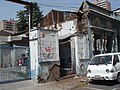
 Structural damage caused by the earthquake
 -
 Slight damage to buildings in Santiago de Chile on the morning after the earthquake
 -
 USGS shake map of the earthquake


Response
Despite Chilean president Michelle Bachelet stated in an early press conference that Chile did not need international aid,[38] leaders of many countries and intergovernmental organizations, including the United Nations and European Union, responded to the earthquake and sent messages of condolence to the government and people of Chile over the loss of lives and property. Argentina, the United States, United Kingdom, People's Republic of China, Singapore, Haiti, and Pakistan were among the countries that responded earliest following the quake.[39][40] Appeals for humanitarian aid were issued by the UK-based Oxfam, Save the Children and others.
Conditions in the aftermath
Four hours after the earthquake, when the death count was still low, Chilean president Michelle Bachelet provided a press conference in which she informed the population of the situation and stated that Chile did not need international aid.[38]
One day after the earthquake, on February 28, 2010, some affected cities were in a state of chaos and massive raids took place on supermarkets in Concepción. The desperate population stole food and other essential products, but electronic equipment and other such items were also taken from the stores. One of the people taking part in the raids reportedly stated, "We are more than 200 people and have nothing. We are willing to pay, but they [the stores] are not selling. We need flour, water and food." In order to control these acts of vandalism, a special force (GOPE) of Carabineros were sent to disperse revolters with tear gas bombs and other riot control equipment.[41]
Tsunami
A tsunami warning was first declared for Chile and Peru,[42] and a tsunami watch for Ecuador, Colombia, Antarctica, Panama and Costa Rica.[43][44] The warning was later extended to a Pacific Ocean-wide warning, covering all coastal areas on the Pacific Ocean except the west coast of the United States, British Columbia, and Alaska.[45] Hawaiian media reported that tsunami warning sirens sounded at 6 am local time.[46] The U.S. Tsunami Warning Center issued advisories about potential tidal waves of less than 1 m (3 ft 3 in) striking the Pacific Ocean coastline between California and most of Alaska late in the afternoon or through the evening 12 or more hours after the initial earthquake.[47]
The tsunami warning was cancelled for all countries except Japan and Russia in PTWC Bulletin 18 of 00:12 UTC on 28 February 2010.[48]
In general, tsunamis tend to come in several waves, of which the first may not be the highest.[49][50]
A tsunami amplitude of up to 2.6 m (8 ft 6 in) high was recorded in the sea at Valparaíso, Chile.[22][51][52] A wave amplitude of 2.34 m (7.68 ft) was recorded at Talcahuano in the Biobío Region.[2] Robinson Crusoe Island, the largest of the Juan Fernández Islands, was struck by a large wave led to the deaths of four people on the island, with eleven people reported as missing, according to Provincial Governor Ivan De La Maza. Chilean president Michelle Bachelet is reported to have sent an aid mission to the remote island.[53][54]
As a precaution against the coming tsunami, partial evacuation was ordered in Easter Island, about 3,510 km away from the coast of Chile. The tsunami wave arrived in Easter Island at 12:05 UTC, measuring 0.35 m.[55][56]
The U.S. National Weather Service's Pacific Tsunami Warning Center issued a tsunami warning throughout a huge swathe of the Pacific region, including Antarctica.[57] In the Americas, the warning extends to Chile (including Easter Island), Colombia, Costa Rica, Ecuador, El Salvador, Guatemala, Mexico, and Panama.[57] A warning was also issued for the Oceania and Pacific Islands nations and territories of American Samoa, Australia, the Cook Islands, the Federated States of Micronesia (including the FSM states of Chuuk, Kosrae, Pohnpei and Yap), Fiji, French Polynesia, Guam, Hawaii, Jarvis Island, Johnston Island, the Kermadec Islands, Kiribati, Marcus Island, the Marshall Islands, Midway Island, New Caledonia, New Zealand, Niue, the Northern Mariana Islands, Palau, Papua New Guinea, Pitcairn Islands, Samoa, the Solomon Islands, Tokelau, Tonga, Tuvalu, Wallis and Futuna and Wake Island.[57] Tsunami warnings are also in effect as far away as East and Southeast Asia including Japan, Indonesia, the Philippines, Russia and Taiwan.[57]
Coastal areas of Canada's westernmost province British Columbia were under a tsunami advisory.[58] No large wave was expected to strike British Columbia, but strong local ocean currents combined with a wave put low-lying coastal regions at risk of flooding.[58] The first wave was expected to reach southern British Columbia at 3:11 p.m. local time.[58] Residents were advised to avoid beaches, harbours and marinas.[59]
A tsunami advisory was also issued for coastal areas of California, Oregon, Washington and southern Alaska in the United States.[60] This tsunami advisory was canceled as of 7:13 AM UTD on February 28th.[61]
Russian authorities lifted a tsunami alert for the Kamchatka coast, after the arrival of a 0.8 meter surge that caused no damage.[62] The tsunami was also reported to be small along the Japanese coast passed without incident. Many coastal areas in Japan had been evacuated as a precaution.[63]
Oceania
- New Zealand
Initially, the New Zealand Ministry of Civil Defence and Emergency Management (CDEM) said they did not expect a tsunami to reach New Zealand,[64] but later issued a warning stating that waves of up to 1 m (3 ft 3 in) high were likely for the eastern[65] and later the entire New Zealand coast.[66] By 7:55 pm UTC (8:40 am local), Civil Defence reported wave activity of 50 cm (1.6 ft) in the Chatham Islands,[67] and 2 m (6 ft 7 in) surges were reported there later in the morning.[68] A surge around 2 m (6 ft 7 in) high hit the South Island's Banks Peninsula,[66] while surges up to 1 m (3 ft 3 in) high were reported in the northern North Island.[69] By mid afternoon (local time), Civil Defence had downgraded the tsunami warning to an alert, while still advising that sea levels could change quickly for up to 24 hours from the initial surge.[70]
- Australia
The Joint Australian Tsunami Warning Center (JATWC) sent out tsunami warnings for New South Wales, Queensland, Lord Howe Island, Norfolk Island, Tasmania, and Victoria. The organization warned of the possibility of dangerous waves, strong ocean currents and foreshore flooding to occur on the east coast of Australia for several hours on Sunday.[71] As a result of the warnings, patrolled beaches in New South Wales and Queensland remained closed (red flags) and lifeguards ushered people to leave the water. However beach goers and surfers have ignored the warnings. Numerous onlookers have also crowded parts of the shore to view potential effects of the tsunami.[72] The beach ban was lifted by the end of the day and there was no reports of damage, flooding or other emergencies. Tsunami waves of between 10cm and 50cm were recorded and their surges were believed to have created strong currents. Increases in sea levels include: Norfolk Island 50cm, Gold Coast (Qld) 20cm, Port Kembla (NSW) 14cm, Southport (Tas) 17cm.[72]
- French Polynesia
A wave measuring up to 6 ft (1.8 m) high struck portions of French Polynesia between 3:50 pm to 5:50 pm UTC (6:50 am to 6:50 am local), with no reports of injuries as of February 28, 2010[update].[73] A wave 4 meters high is reported to have struck Hiva Oa in the Marquesas Islands.[74] The first waves were expected to hit the main island of Tahiti at approximately 4:50 pm UTC (7:50 am local).[75] Cars and other automobiles were banned from roads closer than 500 m (1,600 ft) from the Pacific Ocean.[75]
Réseau France Outre-mer in Papeete reported that a wave measuring less than 1 m (3 ft 3 in) passed east of the Gambier Islands with no damage, according to Monique Richeton, the mayor of Rikitea.[73][75] Residents of the Tuamotus, which are low-lying, were told to move to the highest points on the island.[75]
- American Samoa
The first wave was expected to reach American Samoa, which is still recovering from the 2009 Samoa earthquake and tsunami, at 8:51 local time.[75] Lieutenant Governor Ipulasi Aitofele Sunia urged residents not to rush to A'oloau, a high elevation area on Tutuila, as it could cause traffic jams, putting safety at risk.[75] Many coastal towns, including the main city of Pago Pago, had already been heavily damaged in the 2009 tsunami. The first wave arrived on Pago Plaza at 21:58 UTC.
- Philippines
The Philippine Institute of Volcanology and Seismology (Phivolcs) issued an advisory that tsunami wave(s) were expected to hit the eastern coast of the Philippines on Sunday between 5:00 am and 6:30 am UTC (1:00 pm and 2:30 pm local). Residents of 19 eastern provinces "are advised to prepare for possible evacuation."[76] However, at 3:15 PM on February 28, 2010, all warnings have been cancelled.[77]
North America
- Hawaii
United States Senators Daniel Inouye and Daniel Akaka issued a joint press release announcing the first tsunami evacuation in Hawaii since 1994.[78][79] Warning sirens were sounded throughout the state, as hotels in Waikiki evacuated tourists at 6 a.m. People in tall buildings were encouraged to move above the third floor. Waves measuring nine feet high were originally predicted to strike Hilo Bay on the Big Island of Hawai'i at 11:05 a.m. local time (2105 GMT),[80] but by 11:18 a.m., major receding and waves had not been reported on the shoreline but drops over 10 m (33 ft) and ten wave crests up to 20 m (66 ft) were recorded offshore southeast of Honolulu, and discoloration was reported by 11:20 a.m. By 11:40, several waves hit the islands amounting to raising and lowering of the sea near the coast, and a fourth wave hit around 1:12 p.m. The tsunami warning for Hawaii was canceled in the early afternoon on Saturday, February 27.
Gerard Fryer, a geophysicist for the Pacific Tsunami Warning Center was quoted as saying: “We expected the waves to be bigger in Hawaii, maybe about 50 percent bigger than they actually were." [81] Early in the morning, the Center expected waves of 10 feet. In actuality, the highest tsunami waves ended up being about 5 to 6 feet peak to trough.[82]
- California
Small waves were expected in California, and receding was reported at Long Beach, California. Minor damage was reported on some coastal areas. The tsunami damaged navigation buoys at Ventura, California.[83] Additionally, a boat was torn loose from its mooring and minor erosion occurred within Ventura Harbor. Damage to docks and pilings in the area was moderate.[84]
- British Columbia
At around 11:00 pm UTC (3:00 pm local), a tsunami warning was issued for coastal British Columbia. Extra precautions were already in place due to the 2010 Winter Olympic Games being held in Vancouver at the time.[85]
Question of whether tsunamis were overestimated
The projections use DART (Deep-ocean Assessment and Reporting of Tsunamis) gauges spread along the sea floor, which is a fairly new technology. Initial deep sea readings showed wave height of 25 centimeters, which is huge for deep water according to Gerard Fryer of the Pacific Tsunami Warning Center. He went on to say, “although it was huge, we didn't quite know what it meant because we haven't much experience with those. As we get more under our belts, we'll get better."[82]
Data
The following data, published by the Pacific Tsunami Warning Center and the West Coast and Alaska Tsunami Warning Center, lists measured and reported values of the tsunami when it arrived at specific places.
| Station | Country or territory | Latitude | Longitude | Time (UTC) | Height (m) | Height (ft) |
|---|---|---|---|---|---|---|
| Minamitorishima[88] | 24.1N | 153.5E | 03:43 | 0.1 | 0.3 | |
| Guam | 13.4 N | 144.7 E | 03:07 | 0.16 | 0.5 | |
| Sitka, Alaska | 57.1 N | 135.3 W | 00:11 | 0.08 | 0.3 | |
| Nawiliwili, Hawaii | 22 N | 159.4 W | 23:23 | 0.37 | 1.2 | |
| Johnston Atoll | 16.7 N | 169.5 W | 22:48 | 0.22 | 0.7 | |
| Vanuatu | 17.8 S | 168.3 E | 22:46 | 0.15 | 0.5 | |
| Crescent City, California | 41.7 N | 124.2 W | 22:13 | 0.37 | 1.2 | |
| Kawaihae, Hawaii | 20 N | 155.5 W | 22:11 | 0.52 | 1.7 | |
| Honolulu, Hawaii | 21.3 N | 150.4 W | 22:00 | 0.25 | 0.8 | |
| Barber's Point, Hawaii | 21.3 N | 158.1 W | 21:57 | 0.12 | 0.4 | |
| Santa Barbara, California | 34.4 N | 119.7 W | 21:50 | 0.53 | 1.7 | |
| Kahului, Hawaii | 20.9 N | 156.5 W | 21:47 | 0.98 | 3.2 | |
| Kuamalapau, Hawaii | 20.8 N | 156.9 W | 21:36 | 0.18 | 0.6 | |
| Hilo, Hawaii | 19.7 N | 154.9 W | 21:20 | 0.86 | 2.8 | |
| San Francisco, California | 37.8 N | 122.5 W | 21:20 | 0.26 | 0.8 | |
| San Diego, California | 32.7 N | 117.2 W | 20:36 | 0.13 | 0.4 | |
| Monterey, California | 36.6 N | 121.9 W | 20:31 | 0.28 | 1.1 | |
| Pago Pago | 14.3 S | 170.7 W | 20:27 | 0.22 | 0.7 | |
| Nukualofa | 21.1 S | 175.2 W | 20:24 | 0.1 | 0.3 | |
| Apia | 13.8 S | 171.8 W | 20:18 | 0.13 | 0.4 | |
| DART Tonga | 23 S | 168.1 W | 20:03 | 0.04 | 0.1 | |
| Lottin Point | 37.6 S | 178.2 E | 19:34 | 0.15 | 0.5 | |
| Acapulco | 16.8 N | 99.9 W | 19:31 | 0.62 | 2 | |
| Rarotonga | 21.2 S | 159.8 W | 19:07 | 0.15 | 0.5 | |
| Cabo San Lucas | 22.9 N | 109.9 W | 18:33 | 0.36 | 1.2 | |
| Papeete | 17.5 N | 149.6 W | 18:10 | 0.16 | 0.5 | |
| Nuku Hiva | 8.9 S | 140.1 W | 17:45 | 0.95 | 3.1 | |
| Hiva Oa | 9.8 N | 139.0 W | 17:41 | 1.79 | 5.9 | |
| Manzanillo | 19.1 N | 104.3 W | 17:05 | 0.32 | 1 | |
| DART Manzanillo | 16.0 N | 107 W | 16:11 | 0.07 | 0.2 | |
| Rikitea | 23.1 S | 134.9 W | 15:59 | 0.15 | 0.5 | |
| DART Marquesas Islands | 8.5 S | 125 W | 15:31 | 0.18 | 0.6 | |
| Galapagos Islands | 0.4 S | 90.3 W | 14:52 | 0.35 | 1.2 | |
| Quepos | 14:16 | 0.24 | 0.8 | |||
| Easter Island | 27.2 S | 109.5 W | 12:05 | 0.35 | 1.1 | |
| Callao | 12.1 S | 77.2 W | 10:29 | 0.36 | 1.2 | |
| Arica | 18.5 S | 70.3 W | 10:08 | 0.94 | 3.1 | |
| Antofagasta | 23.2 S | 70.4 W | 09:41 | 0.49 | 1.6 | |
| DART Lima | 18 S | 86.4 W | 09:41 | 0.24 | 0.8 | |
| Iquique | 20.2 S | 70.1 W | 09:07 | 0.28 | 0.9 | |
| Coquimbo | 30 S | 71.3 W | 08:52 | 1.32 | 4.3 | |
| Ancud | 41.9 S | 73.8 W | 08:38 | 0.62 | 2 | |
| Caldera | 27.1 S | 70.8 W | 08:34 | 0.45 | 1.5 | |
| San Felix | 26.3 S | 80.1 W | 08:15 | 0.53 | 1.7 | |
| Corral | 39.9 S | 73.4 W | 07:39 | 0.90 | 2.9 | |
| Valparaiso | 33 S | 71.6 W | 07:08 | 1.29 | 4.2 | |
| Talcahuano | 36.7 S | 73.4 W | 06:53 | 2.34 | 7.7 |
-
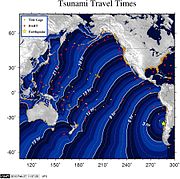 Tsunami ETA NOAA (hour 0=06:34 UTC Feb 27)
 -
 The energy model map of the tsunami.
 -
 Countries with coastal areas at risk (in pink).


See also
- List of earthquakes in Chile
- List of 21st century earthquakes
- List of largest earthquakes by magnitude
Notes
- ^ a b c "PAGER – M 8.8 – OFFSHORE MAULE, CHILE". Earthquake.usgs.gov. Retrieved February 27, 2010.
- ^ a b c TSUNAMI BULLETINS – index of frequently updated bulletins issued by the Pacific Tsunami Warning Center, including the latest.
- ^ . BBC News. February 28 2010 [Chilean quake toll jumps to 708 [http://news.bbc.co.uk/1/hi/world/americas/8542122.stm Chilean quake toll jumps to 708]]. Retrieved 2010-02-28.
{{cite news}}: Check|url=value (help); Check date values in:|date=(help); Missing or empty|title=(help) - ^ a b "Reuters earthquake report". Reuters. Retrieved February 27, 2010.
- ^ "Japan Meteorological Agency report". Japan Meteorological Agency. Retrieved February 27, 2010.
- ^ "USGS Earthquake Details". United States Geological Survey. Retrieved February 27, 2010.
- ^ Patrick Sawer (February 27, 2010). "Huge earthquake hits Chile". The Daily Telegraph. Retrieved February 27, 2010.
- ^ "Historic World Earthquakes". Earthquake.usgs.gov. United States Geological Survey. November 23, 2009. Retrieved February 27, 2010.
- ^ "Huge quake hits Chile; tsunami threatens Pacific". February 26, 2010. Retrieved February 26, 2010.
- ^ a b "Tsunami After Major Earthquake Hits Chile". Sky News. February 27, 2010. Retrieved February 27, 2010.
- ^ "Confirman que el sismo de Chile se sintió en Buenos Aires" (in Spanish). Infobae. February 27, 2010. Retrieved 27 February 2010.
- ^ Infobae.com. February 27, 2010 http://www.infobae.com/general/502942-101275-0-En-la-regi%C3%B3n-Cuyo-se-sinti%C3%B3-muy-fuerte-el-temblor-Chile. Retrieved February 27, 2010.
{{cite news}}: Missing or empty|title=(help); Text "En la región de Cuyo "se sintió muy fuerte" el temblor de Chile" ignored (help) - ^ Peru.com. February 27, 2010 http://www.peru.com/noticias/portada20100227/83441/Temblor-sacude-Ica-y-causa-temor-en-pobladores-tras-terremoto-en-Chile-. Retrieved February 27, 2010.
{{cite news}}: Missing or empty|title=(help) - ^ "Chilean quake toll jumps to 708". BBC News. 2010-02-28. Retrieved 2010-02-28.
- ^ David Batty (27 February 2010). "Deadly earthquake hits central Chile". The Guardian. Retrieved 27 February 2010.
- ^ "Death toll in Chile earthquake rises to 78". RTÉ News. 27 February 2010. Retrieved 27 February 2010.
- ^ "8.8-magnitude quake rocks Chile, sets off tsunami". Los Angeles Times. February 27 2010. Retrieved February 27 2010.
{{cite news}}: Check date values in:|accessdate=and|date=(help) - ^ a b c "Magnitude 8.8 – Offshore Maule, Chile". United States Geological Survey. February 27, 2010. Retrieved February 27, 2010.
- ^ Intensity of shaking in cities around the 2010 Chilean earthquake from USGS
- ^ Erdman, Jonathan (February 27, 2010). "How strong & rare was quake?". The Weather Channel. Retrieved 27 February 2010.
- ^ Fountain, Henry (February 27, 2010). "Underwater Plate Cuts 400-Mile Gash". The New York Times. Retrieved February 27, 2010.
- ^ a b c d e "Massive earthquake strikes Chile", BBC News, 28 February 2010.
- ^ a b Latest Earthquakes M5.0+ in the World, by USGS.
- ^ USGS, Earthquake Hazards Program (February 27, 2010). "10-degree Map Centered at 35°S,75°W". United States Geological Survey. Retrieved 27 February 2010.
- ^ USGS, Earthquake Hazards Program (February 27, 2010). "Magnitude 6.9 - Off the coast of Bio-Bio, Chile". United States Geological Survey. Retrieved February 27, 2010.
- ^ USGS, Earthquake Hazards Program (February 27). "Magnitude 6.3 – SALTA, Argentina". United States Geological Survey. Retrieved 27 February 2010.
{{cite web}}: Check date values in:|date=(help) - ^ "Estado de SP sente reflexo do terremoto de 8,8 graus registrado no Chile" (in Portuguese). Folha Online. February 27, 2010. Retrieved February 27, 2010.
- ^ Vergara, Eva, "8.8-magnitude earthquake hits central Chile", Associated Press, retrieved 27 February 2010.
- ^ Chile President Says Santiago Airport Open With Some Services, Wall Street Journal, FEBRUARY 28, 2010, 2:27 P.M. ET.
- ^ "Massive quake hits Chile, triggers tsunami". MSNBC. 27 February 2010. Retrieved 27 February 2010.
- ^ Rescue efforts continue in Chile, mining industry impacted, Market Watch, Feb. 28, 2010, 12:52 p.m. EST.
- ^ "Terremoto de 8,8 grados deja unos 214 muertos en Chile". El Universo. 2001-02-27. Retrieved 2010-02-28.
- ^ "Corfirman Cien Atrapados Luego Del Terrmoto", Ansa.it, 27 February 2010 Template:Es icon.
- ^ "Chile port town badly damaged by tsunami", Reuters AlertNet, 27 February 2010.
- ^ "Sin agua ni luz se mantiene Temuco bajo constantes movimientos telúricos", CronicaLibre.cl, 27 February 2010 Template:Es icon.
- ^ "Chile quake affects two million, says Bachelet". BBC News. 2010-02-28. Retrieved 2010-02-28.
- ^ "Bachellet confirmó que hay cinco muertos por el sismo en Chile", mdz online, retrieved 27 February 2010. Template:Es icon
- ^ a b "Turba Terremoto en Chile: Aumenta el número de fallecidos. Bachelet descartó tsunami, y dijo que no necesita ayuda internacional". Impulsobaires.com. February 27, 2010. Retrieved 28 February 2010.
- ^ "Int'l community offers sympathy, aid to quake-stricken Chile". Xinhua News Agency. February 28, 2010. Retrieved 27 February 2010.
- ^ Associated Press of Pakistan: President Saddened by Chile Earthquake; Conveys Solidarity to Govt, People of Chile. Retrieved 27 February 2010.
- ^ "Turba saquea varios supermercados en Chile tras caos generado por el sismo de 8.8 grados de magnitud". Peru.com. February 28, 2010. Retrieved 28 February 2010.
- ^ "Australia on tsunami watch after quake". News.ninemsn.com.au. February 27, 2010. Retrieved February 27, 2010.
- ^ "Massive earthquake, aftershocks rattle Chile tsunami warning issued". Time Warner. February 27, 2010. Retrieved February 27, 2010.
{{cite news}}: Unknown parameter|Newspaper=ignored (|newspaper=suggested) (help) - ^ « Strong earthquake hits Chile, Tsunami warning issued in region », peoplestar.co.uk, Retrieved on February 27, 2010.
- ^ "Pacific Tsunami Warning Center". Pacific Tsunami Warning Center. February 27, 2010. Retrieved February 27, 2010.
- ^ "Tsunami warning in effect for Hawaii". Hawaii News Now. February 27, 2010. Retrieved February 27, 2010.
- ^ West Coast and Alaska Tsunami Information
- ^ PTWC Bulletin 18: cancelling warning for all countries except Japan and Russia
- ^ Tsunami threatens Australia, New Zealand, Hawaii, Pacific Rim, By staff writers, From: news.com.au, February 28, 2010 8:59 am.
- ^ New Zealand is among 53 Pacific Ocean nations where tsunami alerts have been issued following an earthquake off Chile, NZCity, 28 February 2010.
- ^ "Tsunami message from WCATWC". Wcatwc.arh.noaa.gov. Retrieved February 27, 2010.
- ^ TSUNAMI BULLETIN NUMBER 004 by the NOAA Pacific Tsunami Warning Center
- ^ Tsunami kills 4 in Robinson Crusoe islands, Agence France-Presse/Reuters.
- ^ Gutierrez, Thelma (2010-02-27). "First waves of tsunami arrive at Hawaii". Honolulu, Hawaii: CNN. Retrieved 27 February 2010.
- ^ http://www.prh.noaa.gov/ptwc/messages/pacific/2010/pacific.2010.02.27.164746.txt
- ^ "Partial evacuation of Chile's Easter Island ordered | ABS-CBN News Online Beta". Abs-cbnnews.com. Retrieved 2010-02-28.
- ^ a b c d Memmott, Mark (February 27, 2010). "'Massive' Earthquake Hits Chile; Tsunami Warnings Up Across Pacific". Los Angeles Times. Retrieved February 27, 2010.
- ^ a b c "Coastal B.C. under tsunami advisory". Vancouver Sun. February 27, 2010. Retrieved February 27, 2010.
- ^ "Coastal B.C. under tsunami advisory after massive Chilean earthquake". Canwest News Service. Montreal Gazette. February 27, 2010. Retrieved February 27, 2010.
- ^ "Tsunami advisory for Washington Coast". MyNorthwest.com. February 27, 2010. Retrieved February 27, 2010.
- ^ Tsunami Advisory Cancellation #25 issued 02/27/2010 at 11:13PM PST, NOAA/NWS/West Coast and Alaska Tsunami Warning Center
- ^ Tsunami waves hit Russia, no damage reported, Reuters
- ^ Japan Breathes Sigh of Relief as Tsunami Passes by Martin Fackler, New York Times, February 28, 2010.
- ^ National Advisory: Tsunami - No Threat to New Zealand, Ministry of Civil Defence & Emergency Management, 20:34 on 27/02/2010.
- ^ National Warning: Tsunami Threat to New Zealand, Ministry of Civil Defence & Emergency Management, 23:18 on 27/02/2010.
- ^ a b NZ on tsunami alert, The Press, 28 February 2010.
- ^ #ChileQuake National Warning:Tsunami Threat to NZ Update18
- ^ Edward Gay and Derek Cheng, 1.5-metre tsunami wave hits Chathams, heading for mainland, New Zealand Herald, 28 February 2010.
- ^ Edward Gay, Derek Cheng and Michael Dickison, Tsunami fears over as alert downgraded, New Zealand Herald, 28 February 2010.
- ^ Tsunami alert for New Zealand after massive Chile quake, stuff.co.nz, 28 February 2010.
- ^ Joint Australian Tsunami Warning Centre: Tsunami Warning is Current. Retrieved February 28, 2010.
- ^ a b Tsunami threatens Australia, New Zealand, Hawaii, Pacific Rim. Retrieved February 28, 2010.
- ^ a b "Tsunami waves up to 6 feet hit French Polynesia". Honolulu Star-Bulletin. Black Press. February 27, 2010. Retrieved February 27, 2010.
- ^ Tsunami hits French Polynesia after Chile earthquake, Agence France-Presse.
- ^ a b c d e f "Tsunami alert in Pacific after 8.8 quake in Chile". Radio New Zealand International. February 27, 2010. Retrieved February 27, 2010.
- ^ Brace for possible tsunami after lunch Sunday – Phivolcs, By Alcuin Papa, Philippine Daily Inquirer, First Posted 02:54:00 02/28/2010
- ^ ALERT CANCELLATION - Phivolcs
- ^ "Inouye, Akaka urge calm". Honolulu Advertiser. February 27, 2010. Retrieved February 27, 2010.
- ^ "Caldwell serving as acting mayor". Honolulu Advertiser. February 27, 2010. Retrieved February 27, 2010.
- ^ Schaefers, Allison (February 27, 2010). "9-foot waves forecast for Hilo Bay at 11:05 a.m." Honolulu Star-Bulletin. Retrieved February 27, 2010.
- ^ Tsunami that raced across Pacific delivers glancing blow to islands, Asian coasts, By JAYMES SONG Associated Press Writer, The Associated Press – HONOLULU, published in Grand Forks Herald, Sunday, February 28, 2010.
- ^ a b Warning center learns from miscalculation, By Gordon Y.K. Pang, Honolulu Advertiser, Sunday, February 28, 2010.
- ^ "Tsunami damages buoys off Ventura, officials say". Santa Clarita Valley Signal. 2010-02-27. Retrieved 2010-02-27.
- ^ "Ventura County gets a surge from tsunami, but no injuries". Ventura County Star. 2010-02-27. Retrieved 2010-02-27.
- ^ Olympic Games proceed despite tsunami warning
- ^ TSUNAMI BULLETIN NUMBER 015 issued by the Pacific Tsunami Warning Center.
- ^ "West Coast and Alaska Tsunami Warning Center". NOAA. Retrieved 2010-02-27.
- ^ 小笠原諸島の南鳥島に津波第一波、10cm
External links
- Aftershock survey
- Maps of the Chile Earthquake from NYT
- Sahana Foundation site - for those wishing to help with the Chile disaster. Note: The site just went up today so much is still being added.