
Mount Royal
| Mount Royal | |
|---|---|
 Mount Royal's eastern slope | |
| Highest point | |
| Elevation | 233 m (764 ft) |
| Prominence | 233 m (764 ft) |
| Isolation | 32.68 km (20.31 mi) |
| Geography | |
| Region | CA-QC |
| Parent range | Monteregian Hills |
| Topo map | USGS Mount Katahdin |
| Geology | |
| Mountain type | Gabbro |
| Climbing | |
| First ascent | Jacques Cartier, 1535 (First European) |
| Easiest route | Hiking or Cycling |

| Mount Royal | |
|---|---|
 | |
| Type | Municipal |
| Location | |
| Coordinates | 45°30′23″N 73°35′20″W / 45.50639°N 73.58889°W |
| Opened | 1876 |
| Operated by | City of Montreal |
| Status | Open all year |

Mount Royal (French: Mont Royal, IPA: [mɔ̃ ʁwajal]) is a mountain in the city of Montreal, immediately north of downtown Montreal, Quebec, Canada, the city to which it gave its name.
The mountain is part of the Monteregian Hills situated between the Laurentians and the Appalachians. It gave its Latin name, Mons Regius, to the Monteregian chain.
The mountain consists of three peaks: Colline de la Croix (or Mont Royal proper) at 233 m (764 ft), Colline d'Outremont (or Mount Murray, in the borough of Outremont ) at 211 m (692 ft), and Westmount[1] at 201 m (659 ft) elevation above mean sea level. At this height, it might be otherwise considered a hill, but it has always been called a mountain, given there are no actual mountains in the Montéregie region.
Geology
Some tourist guidebooks, such as the famous Michelin Guide to Montreal, state that Mount Royal is an extinct volcano. The mountain is not a traditional volcano as such. However, it is the deep extension of a vastly eroded ancient volcanic complex, which was probably active about 125 million years ago.[2] The mountain was created when the North American Plate moved westward over the New England hotspot,[2] along with the other mountains of the Monteregian Hills. The magma intruded into the sedimentary rocks underneath the area, producing at least eight igneous stocks. The main rock type is a gabbro composed of pyroxene, olivine and variable amounts of plagioclase. During and after the main stage of intrusion, the gabbros and surrounding rocks were intruded by a series of volcanic dikes and sills. Subsequently, the surrounding softer sedimentary rock was eroded, leaving behind the resistant igneous rock that forms the mountain.
The mineral montroyalite, discovered in Montreal, is named after the mountain that provided the definition sample.[3]
History
 |
 |
The first European to scale the mountain was Jacques Cartier, guided there in 1535 by the people of the village of Hochelega. He named it in honour of his patron, King François I of France. He wrote in his journal:
- Et au parmy d'icelles champaignes, est scituée et assise ladicte ville de Hochelaga, près et joignant une montaigne ... Nous nommasmes icelle montaigne le mont Royal.
- ("And among these fields is situated and seated the said town of Hochelaga, near to and adjoining a mountain ... We named this mountain, Mount Royal.")
The name of the Island of Montreal derives from mont Réal, as it was spelled in Middle French,[9] ( Mont Royal in present French ) The name was first applied to the island and was unofficially applied to the city, formerly Ville-Marie, by the 18th century.
In 1914-1918, a railway tunnel was dug under the mountain by the Canadian Northern Railway, a predecessor of the Canadian National. It is currently used by the AMT's Montreal/Deux-Montagnes commuter rail line.
The area was briefly considered as the site for Expo 67, before the exposition grounds were ultimately built on islands in the St. Lawrence [4]
For the 1976 Summer Olympics, the park itself hosted the individual road race cycling event.[5]
The Cross
The first Mount Royal Cross was placed there in 1643 by Paul Chomedey de Maisonneuve, the founder of the city, in fulfillment of a vow he made to the Virgin Mary when praying to her to stop a disastrous flood. Today, the mountain is crowned by a 31.4 m (103 ft)-high illuminated cross, installed in 1924 by the Société Saint-Jean-Baptiste and now owned by the city. It was converted to fibre-optic light in 1992, and then to LEDs in 2009. The cross is usually lit in white, but can now be changed to any colour, including the purple traditionally used upon the death of the Pope.
Beside the cross, a plaque marks the placement of a time capsule in 1992, during Montreal's 350th birthday celebration. It contains messages and drawings from 12,000 children, depicting their visions for the city in the year 2142, when the capsule is scheduled to be opened.[6]
Mount Royal Park


The mountain is the site of Mount Royal Park (in French: Parc du Mont-Royal), one of Montreal's largest greenspaces. The park was designed by Frederick Law Olmsted, who also designed New York's Central Park, and inaugurated in 1876, although not completed to his design.
Olmsted had planned to emphasize the mountainous topography through the use of vegetation. Shade trees at the bottom of the carriage path would resemble a valley. As the visitor went higher, the vegetation would get more sparse to give the illusion of exaggerated height. City officials wanted a reservoir atop the mountain instead and Olmsted planned a grand promenade around it. However, Montreal suffered a depression in the mid 1870s and many of Olmsted's plans were abandoned. The carriage way was built, but it was done hastily and without regards to the original plan. None of the vegetation choices was followed, and the reservoir was never built.[7]
The park contains two belvederes, the more prominent of which is the Kondiaronk Belvedere, a semicircular plaza with a chalet, overlooking downtown Montreal. Built in 1906, it is named for the Huron chief Kondiaronk, who signed a major peace accord with the French regime in 1701.[8] As of 2009, the Kondiaronk chalet's snack bar is being shuttered, with plans to replace it with healthier fare.[9]
Other features of the park are Beaver Lake, a small man-made lake; a short ski slope; cross-country skiing trails; a sculpture garden; Smith House, an interpretive centre; and the George-Étienne Cartier Monument. The park hosts athletic, tourist, and cultural activities.
The lush forest was badly damaged both by mayor Drapeau’s morality cuts (to remove any opportunity for people to have sex in the bushes) of the mid-1950’s and by the Ice Storm of 1998, but has since largely recovered. The forest is a green jewel rising above downtown Montreal, and is known for its beautiful autumn foliage as well as extensive hiking and cross-country ski trails. Biking is restricted to the main gravel roads.
From 1885 to 1920, the Mount Royal Funicular Railway brought sightseers to its peak.[10][11] After it ceased service, Montreal's No. 11 streetcar brought visitors to the peak.[12] A roadway named for longtime but controversial former mayor Camillien Houde—jailed during the Second World War for his opposition to Canada's war effort—now bisects the mountain. Ironically, Houde had been opposed to the idea of putting a road through the park
The park, cemeteries, and several adjacent parks and institutions have been combined in the Arrondissement historique et naturel du Mont-Royal (Mount Royal Natural and Historical District) by the government of Quebec, in order to legally protect the rich cultural and natural heritage of this region. It is the only place in Quebec to have the combined status of an arrondissement naturel and arrondissement historique.
Jeanne Mance Park
Facing the mountain across Parc Avenue is Jeanne-Mance Park (Parc Jeanne-Mance), formerly known as Fletcher's Field.[13] A popular recreational area, Jeanne Mance Park features an artificially surfaced field for soccer and football, tennis courts, two baseball diamonds, a kiddie pool, beach volleyball courts and a community composting facility. In the spring of 2009, a children's playground was abruptly demolished by city workers.[14] The park had been the home of the transplanted Crystal Palace from 1878 to 1896, until it was destroyed by fire.
Transmission towers
The park is also home to the CBC's Mount Royal transmitter facility, which comprises two large buildings (one used primarily by the CBC and one used by the private television stations) and a very short (about 100 m (328 ft)) candelabra tower, from which nearly all of Montreal's television and FM radio stations broadcast. Because of the proximity of this tower to public areas of the park, in recent years significant concerns have been raised about radio-frequency radiation exposure; at several points formerly accessible to park users near the tower, radiation was found to be significantly higher than that permitted for the general public.[citation needed]
Adjacent landmarks
Outside the park, Mount Royal's slopes are also home to such Montreal landmarks as St. Joseph's Oratory, Canada's largest church; McGill University and its teaching hospitals, including the Royal Victoria Hospital and Montreal General Hospital; McGill's Molson Stadium, home to the CFL's Montreal Alouettes; the Université de Montréal; the École Polytechnique de Montréal; and some well-off residential neighbourhoods such as Upper Westmount and Upper Outremont.
Cemeteries
There are two cemeteries in the area: Notre Dame des Neiges Cemetery (Catholic), Mount Royal Cemetery (non-denominational but primarily Protestant, and including several small Jewish cemeteries) — all of which are now running out of space.[15]
Wintertime
Mount Royal Park currently hosts a tubing and toboganning run, on one of the former alpine ski slopes.[16]
The former alpine ski slope that is used for toboganning, at one time contained a T-bar, and had a 100-foot drop.[16] Mechanical lift devices were first installed in Mount Royal Park in 1945.[17] A ski shop was first installed in the park in 1908.[18] In the roaring twenties, one of the best ski jumps in Canada was the one on Mount Royal, near Cote des Neiges.[19] In the 1940's there were two and a half miles of ski slopes available.[20]
Mount Royal currently has 18km in 7 groomed cross-country skiing trails, also open for snowshoeing, and rentals are available onsite.[21][22]
Expansion plans
Plans to expand the park to include the Outremont summit have hit a snag, with the Notre Dame des Neiges Cemetery refusing to give up land that it uses as a depot.[23]
Mount Royal's Tam-Tams

In the summer time, Mount Royal hosts a popular activity known as the "Tam Tam Jam", whereby a number of Montrealers and visitors play hand drums ("tam-tams" in French) such as djembes on the east slope of the mountain, at the George-Étienne Cartier Monument. The Sunday gatherings attract people of various backgrounds, and often dozens of tam-tam players perform their art at the same time, encouraging others to dance. In addition, many children and adults participate in a continuous mock medieval battle with foam-padded weapons.[24]
The Tam-tams began in the late '70s with a workshop on African drumming at a jazz bar on Ontario Street.[25] It is not organized by the municipal authorities. Despite initial resistance by participants, the city now intervenes in the event, restricting commercial activity to registered members in designated areas and assigning police and first aid technicians to ensure the safety of those present. Although initially controversial in light of the event's communal and countercultural vibe (and permissive attitude towards marijuana use) the police presence has not led to conflict.
Gallery
This section contains an unencyclopedic or excessive gallery of images. |
-
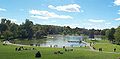 Beaver Lake (Lac aux castors), on Mount Royal
 -
 Beaver Lake (Lac aux castors) with leaves changing, Fall, 2008
 -
 Gravel road
 -
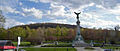 Mount Royal's eastern slope, with the cross and the monument to Sir George-Étienne Cartier, seen from avenue du Parc
 -
Downtown Montreal seen from the mountain
-
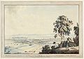 View of Montreal from Mount Royal, 1784
 -
 A lion in winter, Mount Royal, 2008


See also
- Holy Mountain (website), a National Film Board of Canada website devoted to the mountain
- Royal eponyms in Canada
References
- ^ [1]
- ^ a b A Hundred-Million Year History of the Corner Rise and New England Seamounts Retrieved on 1 August 2007
- ^ http://webmineral.com/data/Montroyalite.shtml
- ^ "Did You Know?". Montreal gets the call, cbc.ca. Retrieved 20 February 2008.
- ^ 1976 Summer Olympics official report. Volume 2. pp. 159-61.
- ^ Walking tour: Mount Royal, Frommer's
- ^ Parker, Christopher Glynn. "fredericklawolmsted.com". Retrieved 19 February 2008.
- ^ "ASSIGNMENT #11: Mount Royal". Urban Revitalization in Montreal: Field Trip Manual (PDF). Institute of Urban Studies, University of Winnipeg. 9 May 2005. Retrieved 6 March 2008.
{{cite book}}: Cite has empty unknown parameter:|sectionurl=(help) - ^ CORNACCHIA, Cheryl (25 December 2008). "City-owned snack bars to close". Montreal Gazette. Canwest. Retrieved 25 December 2008. [dead link]
- ^ DeWolf, Christopher (15 January 2008). "Riding the Rails Up Mount Royal". URBANPHOTO. Retrieved 25 March 2008.
- ^ "Mount Royal Funicular Railway, Montreal, QC, about 1900". Wm. Notman & Son, McCord Museum Web site. Retrieved 20 February 2008.
- ^ "Ligne de la Montagne". Archives photographiques de la STM. Retrieved 25 March 2008.
- ^ Goldman, Norman. "Montreal's Eighth Wonder of the World". BootsnAll:The Ultimate Source for the Independent Traveller. Retrieved 19 February 2008..
- ^ Freed, Josh (2 May 2009). "The curious case of the disappearing playground". Montreal Gazette. Canwest. Retrieved 2 May 2009. [dead link]
- ^ Johnston, David (14 November 2006). "Montreal's Mount Royal losing dead space". Montreal Gazette. Canwest. Retrieved 19 February 2008.
- ^ a b Community Walk, "Parc du Mont Royal" (accessed 31 March 2010)
- ^ The Gazette (Montreal), "Mount Royal May Have Ski Tows; Heavy Snows Herald Early Season", Bill Weintraub, 29 December 1944 (accessed 31 MArch 2010)
- ^ The Gazette (Montreal), "Mount Royal Ski", Stan Helleur, 19 January 1910 (accessed 31 March 2010)
- ^ The Daily Times, "Ski Jumper Leaving Take Off For Long Flight Down Mount Royal", 15 January 1920 (accessed 31 March 2010)
- ^ New York Times, "Ski Slopes and Trails", Frank Elkins, 7 December 1948
- ^ Canada Trails, "Cross Country Skiing in Quebec" (accessed 31 March 2010)
- ^ Bonjour Quebec, "Mount Royal Park" (accessed 31 March 2010)
- ^ Champagne, Sara (18 December 2008). "Le projet de grand parc bat de l'aile". La Presse (in French). Retrieved 25 December 2008.
{{cite news}}: Cite has empty unknown parameter:|curly=(help) - ^ DeWolf, Christopher (10 September 2007). "Joining the medieval battle on Mount Royal". Spacing Montreal. Retrieved 20 February 2008.
- ^ Krashinsky, Susan. "Turning the beat around". Montréal Magazine. Retrieved 11 May 2008.
External links
| Montreal Olympic Park |  | |
|---|---|---|
| Greater Montreal | ||
| Football venues | ||
| Handball venues | ||
| Other venues | ||
| Quebec City area | |
|---|---|
| Montreal local area |
|
| Laurentides area: Montreal-area Laurentians | |
| Eastern Townships: | |
| Gatineau area: Ottawa-area Laurentians | |
| Lanaudière area: Montreal-area Laurentians | |
| Saguenay–Lac-Saint-Jean | |
| Bas-Saint-Laurent | |
| Abitibi-Témiscamingue | |
| |