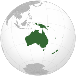
American Samoa
American Samoa Amerika Sāmoa / Sāmoa Amelika | |
|---|---|
| Motto: "Samoa, Muamua Le Atua" (Samoan) "Samoa, Let God Be First" | |
| Anthem: The Star-Spangled Banner, Amerika Samoa | |
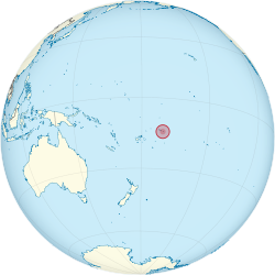 | |
| Capital | Pago Pago1 (de facto), Fagatogo (seat of government) |
| Official languages | English, Samoan |
| Demonym(s) | American Samoan |
| Government | Unincorporated territory of the United States |
| Barack Obama (D) | |
• Governor | Togiola Tulafono (D) |
| Ipulasi Aitofele Sunia (D) | |
| Unincorporated territory of the United States | |
• Tripartite Convention | 1899 |
• Deed of Cession of Tutuila | 1900 |
• Deed of Cession of Manu'a | 1904 |
• Annexation of Swains Island | 1925 |
| Area | |
• Total | 199 km2 (77 sq mi) (212th) |
• Water (%) | 0 |
| Population | |
• 2009 estimate | 66,432 (196th) |
• 2000 census | 57,291 |
• Density | 326/km2 (844.3/sq mi) (35th) |
| GDP (PPP) | 2007 estimate |
• Total | $575.3 million |
| Currency | US dollar (USD) |
| Time zone | UTC-11 (Samoa Standard Time) |
• Summer (DST) | not observed |
| Calling code | +1-684 |
| ISO 3166 code | AS |
| Internet TLD | .as |
| |


American Samoa (/əˈmɛrɨkən səˈmoʊ.ə/ ; [Amerika Sāmoa; also Amelika Sāmoa or Sāmoa Amelika] Error: {{Lang-xx}}: text has italic markup (help)) is an unincorporated territory of the United States located in the South Pacific Ocean, southeast of the sovereign state of Samoa (formerly known as Western Samoa). The main (largest and most populous) island is Tutuila, with the Manuʻa Islands, Rose Atoll, and Swains Island also included in the territory.
American Samoa is part of the Samoan Islands chain, located west of the Cook Islands, north of Tonga, and some 300 miles (500 km) south of Tokelau. To the west are the islands of the Wallis and Futuna group. The 2000 census showed a total population of 57,291 people.[1] The total land area is 76.1 square miles (197.1 km2), slightly more than Washington, D.C. American Samoa is the southernmost territory of the United States.[2]
History
18th century – first Western contact

Contact with Europeans began in the early 18th century. Jacob Roggeveen (1659–1729), a Dutchman, was the first known European to sight the Samoan islands in 1722. This visit was followed by a French explorer by the name of Louis-Antoine de Bougainville (1729–1811), the man who named them the Navigator Islands in 1768. Contact was limited before the 1830s which is when English missionaries and traders began arriving.
Early Western contact included a battle in the eighteenth century between French explorers and islanders in Tutuila, for which the Samoans were blamed in the West, giving them a reputation for ferocity. The site of this battle is called Massacre Bay.
19th century
Mission work in the Samoas had begun in late 1830 by John Williams, of the London Missionary Society arrived from The Cook Islands and Tahiti.[3] By that time, the Samoans had gained a reputation of being savage and warlike, as violent altercations had occurred between natives and French, British, German and American forces, who, by the late nineteenth century, valued Pago Pago Harbor as a refueling station for coal-fired shipping and whaling.
20th century

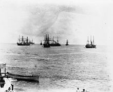
In March 1889, a German naval force invaded a village in Samoa, and by doing so destroyed some American property. Three American warships then entered the Apia harbor and were prepared to fire on the three German warships found there.[citation needed] Before guns were fired, a typhoon wrecked both the American and German ships. A compulsory armistice was called because of the lack of warships.[citation needed]
At the turn of the twentieth century, international rivalries in the latter half of the century were settled by the 1899 Tripartite Convention in which Germany and the United States partitioned the Samoan Islands into two parts:[4] the eastern island group became a territory of the United States (the Tutuila Islands in 1900 and officially Manu'a in 1904) and is today known as American Samoa; the western islands, by far the greater landmass, became known as German Samoa after Britain vacated all claims to Samoa and accepted termination of German rights in Tonga and certain areas in the Solomon Islands and West Africa.[5] Forerunners to the Tripartite Convention of 1899 were the Washington Conference of 1887, the Treaty of Berlin of 1889 and the Anglo-German Agreement on Samoa of 1899.
A U.S. territory is born

The following year, the U.S. formally occupied its portion: a smaller group of eastern islands, one of which surrounds the noted harbor of Pago Pago. After the United States Navy took possession of eastern Samoa on behalf of the United States, the existing coaling station at Pago Pago Bay was expanded into a full naval station, known as United States Naval Station Tutuila under the command of a commandant. The Navy secured a Deed of Cession of Tutuila in 1900 and a Deed of Cession of Manuʻa in 1904. The last sovereign of Manuʻa, the Tui Manuʻa Elisala, was forced to sign a Deed of Cession of Manuʻa following a series of U.S. Naval trials, known as the "Trial of the Ipu", in Pago Pago, Taʻu, and aboard a Pacific Squadron gunboat.[6]
The early century and WW I
After World War I, during the time of the Mau movement in Western Samoa (then a League of Nations mandate governed by New Zealand), there was a corresponding American Samoa Mau movement,[6] led by Samuel Sailele Ripley, a World War I veteran who was from Leone village. After meetings in the United States mainland, he was prevented from disembarking from the ship that brought him home to American Samoa and was not allowed to return because the American Samoa Mau movement was suppressed by the U.S. Navy. In 1930 the U.S. Congress sent a committee to investigate the status of American Samoa, led by Americans who had had a part in the overthrow of the Kingdom of Hawaii.
The Pacific War (WW II)
During World War II, U.S. Marines in Samoa outnumbered the local population, having a huge cultural influence. Young Samoan men from the age of 14 and above were combat trained by U.S. military personnel. Samoans served in various capacities during World War II, including as combatants, medical personnel, code personnel, and ship repairmen.
After World War II, Organic Act 4500, a U.S. Department of Interior-sponsored attempt to incorporate American Samoa, was defeated in Congress, primarily through the efforts of Samoan chiefs, led by Tuiasosopo Mariota.[7] These chiefs' efforts led to the creation of a local legislature, the American Samoa Fono which meets in the village of Fagatogo, often considered the territory's de facto and de jure capital (the United States regards Pago Pago as the official capital of the territory).
The latter century: 1951 to 1999
In time, the Navy-appointed governor was replaced by a locally elected one. Although technically considered "unorganized" since the U.S. Congress has not passed an Organic Act for the territory, American Samoa is self-governing under a constitution that became effective on July 1, 1967. The U.S. Territory of American Samoa is on the United Nations list of Non-Self-Governing Territories, a listing which is disputed by the territorial government officials, who do consider themselves to be self-governing.
In July 1997, the Western Samoa's constitution was amended to change the name of the country to Samoa.[8] The U.S. territory of American Samoa protested the move, asserting that the change diminished its own identity. American Samoans still use the terms Western Samoa and Western Samoans to describe the independent State of Samoa and its inhabitants.
While the two Samoas share language and ethnicity, their cultures have recently followed different paths, with American Samoans often emigrating to Hawaiʻi and the U.S. mainland, and adopting many U.S. customs, such as the playing of American football and baseball. Western Samoans have tended to emigrate instead to New Zealand, whose influence has made the sports of rugby and cricket more popular in the western islands. Travel writer Paul Theroux noted that there were marked differences between the societies in Samoa and American Samoa.
21st Century
Due to economic hardship, military service has been seen as an opportunity in American Samoa and other U.S. Overseas territories,[9] this has meant that based on population there have been a disproportionate number of casualties per population compared to other parts of the United States. As of 23 March 2009[update] there have been 10 American Samoans who have died in Iraq, and 2 who have died in Afghanistan.[10]
World Stage Events
Pan American and first Trans South Pacific flight
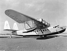
In 1938, the noted aviator Ed Musick and his crew died on the Pan American World Airways S-42 Samoan Clipper over Pago Pago, while on a survey flight to Auckland, New Zealand. Sometime after take-off, the aircraft experienced trouble, and Musick turned it back toward Pago Pago. While the crew began dumping fuel in preparation for an emergency landing, a spark in the fuel pump caused an explosion that tore the aircraft apart in mid-air.[11]
Apollo Space Program and American Samoa contribution

American Samoa and Pago Pago International Airport had historic significance with the U.S. Apollo Program.[12] The astronaut crews of Apollo 10, 12, 13, 14, and 17 were retrieved a few hundred miles from Pago Pago and transported by helicopter to the airport prior to being flown to Honolulu on C-141 Starlifter military aircraft.[13]
September 2009 earthquake and tsunami
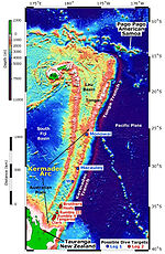
On September 29, 2009 at 17:48:11 UTC, an 8.1 magnitude earthquake struck 120 miles (190 km) off the coast of American Samoa, followed by smaller aftershocks.[14] It was the largest earthquake of 2009. The quake occurred on the outer rise of the Kermadec-Tonga Subduction Zone. This is part of the Pacific Ring of Fire, where tectonic plates in the Earth's lithosphere meet and earthquakes and volcanic activity are common. The quake struck 11.2 miles (18.0 km) below the ocean floor and generated an onsetting tsunami that killed more than 170 people in the Samoa Islands and Tonga.[15][16] Four waves with heights from 15 feet (4.6 m) to 20 feet (6.1 m) high were reported to have reached up to one mile (1.6 km) inland on the island of Tutuila.[17]
The Defense Logistics Agency (DSCP) worked with the Federal Emergency Management Agency (FEMA) to provide 16’ x 16’ humanitarian tents to the devastated areas of American Samoa.
Politics

Politics of American Samoa takes place in a framework of a presidential representative democratic dependency, whereby the Governor is the head of government, and of a pluriform multi-party system. American Samoa is an unincorporated and unorganized territory of the United States, administered by the Office of Insular Affairs, U.S. Department of the Interior. Its constitution was ratified in 1966 and came into effect in 1967. Executive power is exercised by the governor. Legislative power is vested in the two chambers of the legislature. The American political parties (Republican and Democratic) exist in American Samoa, but few politicians are aligned with the parties. The judiciary is independent of the executive and the legislature.
There is also the traditional village politics of the Samoa Islands, the "fa'amatai" and the "fa'asamoa", which continues in American Samoa and in independent Samoa, and which interacts across these current boundaries. The Fa'asamoa is the language and customs, and the Fa'amatai the protocols of the "fono" (council) and the chief system. The Fa'amatai and the Fono take place at all levels of the Samoan body politic, from the family, to the village, to the region, to national matters.
The "matai" (chiefs) are elected by consensus within the fono of the extended family and village(s) concerned. The matai and the fono (which is itself made of matai) decide on distribution of family exchanges and tenancy of communal lands. The majority of lands in American Samoa and independent Samoa are communal. A matai can represent a small family group or a great extended family that reaches across islands, and to both American Samoa and independent Samoa.
One issue that has caused quite a bit of criticism was a decision approved by the "Constitution Convention", held locally. The decision was to allow only U.S Nationals with Samoan ancestry to be legislators.[18]
Nationality
People born in American Samoa — including those born on Swains Island — are American nationals,[19] but are not American citizens unless one of their parents is a U.S. citizen. As U.S. nationals, American Samoans may not vote in U.S. presidential elections.[19] However, American Samoans are entitled to free and unrestricted entry into the United States.[19]
Samoans are entitled to elect one non-voting delegate to the United States House of Representatives.[19] Their delegate since 1989 has been Democrat Eni Fa'aua'a Hunkin Faleomavaega, Jr. They also send delegates to the Democratic and Republican National Conventions.
Administrative divisions
American Samoa is administratively divided into three districts and two "unorganized" atolls. The districts and unorganized atolls are subdivided into 74 villages. Pago Pago—the capital of American Samoa[20] – is one of the largest villages and is located on the eastern side of Tutuila island in Ma'oputasi County district #9. Fagatogo is listed in the Constitution of American Samoa as the official seat of government, but it is not the capital.[21][22][23]
Geography
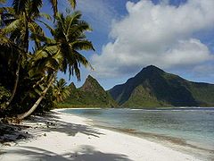
American Samoa, located within the geographical region of Oceania, is one of only two possessions of the United States in the Southern Hemisphere, the other being Jarvis Island. Its total land area is 76.1 square miles (197.1 km2) – slightly larger than Washington, D.C. – consisting of five rugged, volcanic islands and two coral atolls.[2] The five volcanic islands are: Tutuila, Aunu'u, Ofu, Olosega, Tau. The coral atolls are: Swains, and Rose Atoll. Of the seven islands, Rose Atoll is an uninhabited Marine National Monument.
Due to its positioning in the South Pacific Ocean, it is frequently hit by tropical cyclones between November and April. Rose Atoll is the easternmost point of the territory. American Samoa is the southernmost part of the United States. American Samoa is home to the National Park of American Samoa.
Official protest to naming of neighboring Samoa
The United States Department of State Background Note web page for neighboring Samoa notes that "in July 1997 the Constitution was amended to change the country's name from Western Samoa to Samoa (officially the "Independent State of Samoa"). Western Samoa had been known simply as Samoa in the United Nations since joining the organization in 1976. The neighboring U.S. territory of American Samoa protested the move, feeling that the change diminished its own Samoan identity. American Samoans still use the terms Western Samoa and Western Samoans."[24]
Geology
Vailulu'u Seamount
The Vailulu'u Seamount, an active submerged volcano, lies 28 miles (45 km) east of Ta'u in American Samoa. It was discovered in 1975 and has since been studied by an international team of scientists, contributing towards understanding of the Earth's fundamental processes.[25] Growing inside the summit crater of Va'ilulu'u is an active underwater volcanic cone, named after Samoa's goddess of war, Nafanua.
Economy
Employment on the island falls into three relatively equal-sized categories of approximately 5,000 workers each: the public sector, the single remaining tuna cannery, and the rest of the private sector.
There are only a few federal employees in American Samoa and no active duty military personnel except members of the U.S. Coast Guard, although there is an Army Reserve unit. There is also a U.S. Army recruiting station in Utulai.
The overwhelming majority of public sector employees work for the American Samoa territorial government. The one tuna cannery, StarKist, ships several hundred million dollars worth of canned tuna to the rest of the United States each year. The other tuna cannery, Samoa Packing, a Chicken of the Sea subsidiary, closed in 2009 due to American Samoans being granted minimum wage.[26] In early 2007 the Samoan economy was highlighted in the Congress as it was not mentioned in the minimum wage bill, at the request of the Samoan delegate to the United States House of Representatives, Eni Faleomavaega.[clarification needed]
The Fair Labor Standards Act of 1938 has, since inception, contained special provisions for American Samoa, citing its limited economy.[27] American Samoa wages are based on the recommendations of a Special Industry Committee meeting bi-annually.[28] Originally, the Act contained provisions for other territories, provisions which were phased out as those territories developed more diverse economies.[29]
In 2007, the Fair Minimum Wage Act of 2007 was passed, increasing minimum wage in American Samoa by 50¢ per hour in 2007 and another 50¢ per hour each year thereafter until the minimum wage in American Samoa equals the federal minimum wage of $7.25 per hour in the United States.[30] In response to the minimum wage increase, one of the two major tuna canning plants in American Samoa, Chicken of the Sea, was shut down in 2009 and 2,041 employees were laid off in the process.[31] The other major tuna canning plant in American Samoa, StarKist, began laying off workers in August 2010, with plans to lay off a total of 800 workers due to the minimum wage increases and other rising operation costs.[32] American Samoa Governor Togiola Tulafono has suggested that, rather than laying off minimum wage workers, the companies could reduce salaries and bonuses of top-tier employees.[33]
The Unemployment rate was 29.8% (2005), but has been improved to 23.8% as of (2010). Samoa GDP is $575.3 million and its GDP - per capita (PPP) is $8,000 (2007). American Samoa economy is generally better than that of its neighbors like Samoa where American Samoa GDP - per capita (PPP) is more than twice as good as Samoa's.
Transportation


American Samoa has a total of 241 km of highways (estimated in 2008).[34] Ports and harbors include Aunu‘u, Auasi, Faleāsao, Ofu and Pago Pago.[34] American Samoa has no railways.[34] The country has three airports, all of which have paved runways. The main airport is Pago Pago International Airport.[34] Per a 1999 estimate, there are no merchant marines in American Samoa.[34]
Demographics
| Census | Pop. | Note | %± |
|---|---|---|---|
| 1970 | 27,159 | — | |
| 1980 | 32,297 | 18.9% | |
| 1990 | 46,773 | 44.8% | |
| 2000 | 57,291 | 22.5% |
The population of American Samoa stands at about 65,000 people, 95% of whom live on the largest island, Tutuila.[19]
Of the population, 91.6 percent are native Samoans, 2.8% are Asian, 1.1% are Caucasian, 4.2% are Mixed, and 0.3% are of other origin. Samoan is spoken by 90.6 percent of the people closely related to Hawaiian and other Polynesian languages), while 2.9% speak English, 2.4% speak Tongan, 2.1% speak other languages, and 2% speak other Pacific islander languages, with most people being bilingual. American Samoa is largely Christian (50% Christian Congregationalist, 20% Roman Catholic, 30% Protestant and other).[20]
American Samoa is small enough to have just one ZIP code, 96799, and uses the U.S. Postal Service (state code "AS") for mail delivery.[35][36] The island contains 23 primary schools and six secondary schools, all of which are operated by the American Samoa Department of Education.[37] American Samoa Community College, founded in 1970, provides post-secondary education on the islands.
Culture
This section needs expansion. You can help by adding to it. (June 2008) |
The ethnic culture of American Samoa is almost the same as the ethnic culture of Western Samoa (Upolu). The U.S. sovereignty distinguishes the civilization of American Samoa from the sovereign Samoa.[38]
Religion
According to the World Christian Database, the population of American Samoa is 98.3% Christian, 0.7% agnostic, 0.3% Chinese Universalist, 0.3% Buddhist, 0.3% Baha'i and 0.1% Mahanugan.[39]
As of 2010[update], the CIA Factbook showed the religious affiliations of American Samoa as Christian Congregationalist 50%, Roman Catholic 20%, Protestant and other 30%.[40]
As of 2010[update], The Church of Jesus Christ of Latter-day Saints website reports membership in 1990 was 7,500, increasing to about 12,000 in 1994, which is about one in four American Samoans.[41]
Sports
The main sports played in American Samoa are Samoan cricket, baseball, basketball, soccer, and American football. In Samoan villages, volleyball is also popular.
American football
About 30 ethnic Samoans, many from American Samoa, currently play in the National Football League, and more than 200 play NCAA Division I college football.[42] In recent years, it has been estimated that a Samoan male (either an American Samoan, or a Samoan living in the 50 United States) is anywhere from 40[43] to 56 times[42] more likely to play in the NFL than a non-Samoan American. Nine-time All-Pro Junior Seau is one of the most famous Samoans ever to play in the NFL, having been elected to the NFL 1990s All-Decade Team. Pittsburgh Steelers safety Troy Polamalu, though born and raised in the mainland U.S., is perhaps the most famous Samoan currently in the NFL, not having his hair cut since 2000 (and only because a USC coach told him he had to) and wearing it down during games in honor of his heritage. The football culture was featured on 60 Minutes January 17, 2010.
Professional wrestling
A number of American Samoan athletes have been very visible in boxing, kickboxing, wrestling (see especially Anoa'i family). World Wrestling Entertainment has employed many members from the Anoa'i family, most famously Dwayne "The Rock" Johnson. Also in professional wrestling, a wrestler called Samoa Joe competes in Total Nonstop Action Wrestling.
Sumo wrestling
Some Samoan Sumo wrestlers, most famously Musashimaru and Konishiki have reached the highest rank of Ozeki and yokozuna. Despite the relatively small population of the islands many Samoans and people of Samoan descent have reached high ranks in many professional sports leagues.
Soccer
American Samoa's national soccer team is one of the newest teams in the world. It also has the distinction of suffering the worst loss in international soccer history: they lost to Australia 31 – 0 in a FIFA World Cup qualifying match on April 11, 2001.
See also
References
Bibliography
- Ellison, Joseph (1938). Opening and Penetration of Foreign Influence in Samoa to 1880. Corvallis: Oregon State College.
- Sunia, Fofo (1988). The Story of the Legislature of American Samoa. Pago Pago: American Samoa Legislature.
- Meti, Lauofo (2002). Samoa: The Making of the Constitution. Apia: Government of Samoa.
External links
- American Samoa at Curlie
- Government of American Samoa
 Wikimedia Atlas of American Samoa
- Template:Wikitravel
Country data
- "American Samoa". The World Factbook (2024 ed.). Central Intelligence Agency.
- American Samoa national profile from the Association of Religion Data Archives


