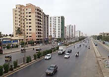
Federal B. Area
Federal B. Area(Template:Lang-ur) is a residential area of Gulberg Town in Karachi, Sindh, Pakistan.[1]

After the independence of Pakistan in 1947, thousands of federal government employees had migrated to Pakistan and faced housing crisis. In 1953, Prime Minister Muhammad Ali Bogra had initiated the housing scheme for low-paid government employees and it was named as Mansura but the name 'Federal B. Area' for the same housing scheme became much more popular among the people of Karachi.[2]
There are several ethnic groups in Federal B Area including Muhajirs, Memons, Bohras and Ismailis.
When Pakistan came into being the port city of Karachi was chosen as the capital of the federation. An area within Karachi was selected to serve as the home of federal government offices and employees and house other important buildings. This area was named as Federal Capital Area or F.C. Area. The residential area around F.C. Area came to be known by the people as Federal B Area or F.B. Area. Block 14 has a notable Ansari House near Falah Mosque and Talimi Bagh which is famous in Dastagir.
The area surrounding the FC and FB Area was designated as Buffer Zone, all residential construction was barred in the buffer zone to keep the main population of the city of Karachi at bay from the sensitive FC Area. However, when the capital of Pakistan was moved from Karachi to Islamabad, the Federal Capital Areas name changed to Federal B Area as it is known in 2012.
A number of blocks of the area are better known by other names. This includes Azizabad which is block 8, Naseerabad which is block 14 and Dastagir Colony which includes a number of blocks.
Federal B. Area |
|---|
F.B. Area (Gulberg Town) is defined by physical features such as Lyari River, Gujjar Nala, and Circular Railway Line. The population of the Union Councils is on the higher side[clarification needed] because this is a developed area, thickly populated and further division beyond the Census Circle is not possible. Therefore, main roads were taken as boundaries of the Union Councils, which restricted the leverage available to create Union Councils of 50,000 populations.
History
The town planning of Federal-B-Area dates back to the 1950s when Karachi was still the capital of Pakistan and many new neighborhoods were getting built up to house the employees of the federal government. The present-day neighborhoods of North Nazimabad and Federal-B-Area were all part of this vision to give Karachi a well planned capital city infrastructure. During Pervaiz Musharraf's tenure, Federal-B-Area neighborhood was renamed again and it became Gulberg Town, but the original name still remains popular and also written as the address on postal mail.
Shahrah-e-Pakistan
Another aspect of Federal-B-Area's geography is that Shahrah-i-Pakistan runs through it. This main artery of the city roughly bisects Federal-B-Area into two zones. The importance of Shahrah-i-Pakistan cannot be overlooked. It is the same road which runs from Karachi Port to all the way to Landi Kotal in NWFP.
Neighbourhoods
This council councillor name is Mudassir Hussain.
- Samanabad (Karachi)
- Aisha Manzil (Karachi)
- Ancholi Karachi
- Azizabad Karachi
- Karimabad
- Shafiq Mill Colony
- Naseerabad
- Water Pump
- Yaseenabad
- Dastagir
See also
- Federal Capital Territory
- Gulberg Town
- Dastagir
- Dastagir Colony
- Talimi Bagh
- Azizabad
- Aisha Manzil
- Sindh Baloch Cooperative Housing Society
References
- ^ http://www.dawn.com/news/1202831, 'Culture centre, 'cinema' sealed in Karachi' in the Federal B. Area of Karachi, Dawn newspaper, Updated 26 August 2015, Retrieved 17 February 2017
- ^ A story behind every name
